Cataloged map
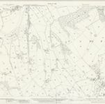
Lancashire LIV.15 (includes: Clayton Le Dale; Dutton; Salesbury) - 25 Inch Map

Institution:National Library of Scotland
Full title:Lancashire LIV.15 (includes: Clayton Le Dale; Dutton; Salesbury) - 25 Inch Map
Depicted:1930
Pubdate:1932
Publisher:Ordnance Survey
Map scale:1:2 500