Maps of Switzerland

Carte générale des trèze cantons de Suisse, Vallay, ligues Grise, Maison-Dieu & Valteline
1 : 725000 1 Karte A Paris au bout du pont neuf proche les Augustins
<<Die>> Helvetische Republik in Cantone und Districte eingetheilt
1 : 630000 1 Karte gedruckt bey Wilhelm Haas dem Sohne, Basel
<<Die>> Helvetische Republik in Cantone und Districte eingetheilt
1 : 630000 1 Karte gedruckt bey Wilhelm Haas dem Sohne, Basel
Historisch-Geographischer Atlas der Schweiz in 15 Blättern
1 : 770000 Eidgenossenschaft 1412 - 1481 Voegelin, Johann Conrad ; Meyer von Knonau, Gerold ; Wyss, Georg von ; Meyer von Knonau, Gerold Schulthess
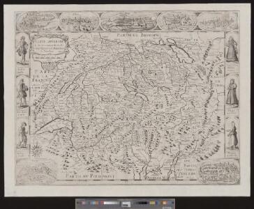
<<La>> Suisse divisée en ses treze cantons, ses alliéz & ses sujets
1 : 480000 1 Karte par le Sr. Sanson, géographe du roy chez H. Jaillot, Paris
<<La>> Suisse divisée en ses treize cantons et ses alliés
1 : 850000 1 Karte projettée et assujettie aux observations astronomiques par [Rigobert] Bonne chez Lattré, rue S. Jacques, à la ville de Bordeaux, Paris
Historisch-Geographischer Atlas der Schweiz in 15 Blättern
1 : 770000 Helvetien 888 - 1037 Voegelin, Johann Conrad ; Meyer von Knonau, Gerold ; Wyss, Georg von ; Meyer von Knonau, Gerold Schulthess
Carte physique et politique de la Suisse
1 : 900000 1 Karte par E. Mentelle et P.G. Chanlaire an VI ; gravé par [Alexandre] Blondeau P.G. Chanlaire et E. Mentelle, Paris
<<Les>> XIII. cantons des Suisses, leurs alliéz et leurs sujets
1 : 1000000 1 Karte par N. de Fer ; C. Inselin sculpt. chez l'auteur dans l'Isle du Palais à la Sphère Royale, Paris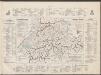
Historisch-Geographischer Atlas der Schweiz in 15 Blättern
1 : 770000 Eidgenossenschaft 1481 - 1652 Voegelin, Johann Conrad ; Meyer von Knonau, Gerold ; Wyss, Georg von ; Meyer von Knonau, Gerold Schulthess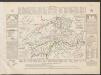
Historisch-Geographischer Atlas der Schweiz in 15 Blättern
1 : 770000 Helvetien 450 - 879 Voegelin, Johann Conrad ; Meyer von Knonau, Gerold ; Wyss, Georg von ; Meyer von Knonau, Gerold Schulthess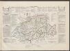
Historisch-Geographischer Atlas der Schweiz in 15 Blättern
1 : 770000 Helvetien 1218 - 1331 Voegelin, Johann Conrad ; Meyer von Knonau, Gerold ; Wyss, Georg von ; Meyer von Knonau, Gerold Schulthess
Carte physique et politique de la Suisse
1 : 1050000 1 Karte dréssée par L. Dussieux ; gravée par Martier [Lecoffre], [Paris]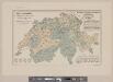
Karte der Schweiz mit Angabe der Kantons- und der Bezirksgrenzen
1 : 1050000 1 Karte vom eidg. statistischen Bureau ; Lith. Gebr. Kümmerly Eidg. statist. Bureau, [Bern]
Helvetiae, Rhaetiae & Valesiae cum omnibus finitimis regionibus tabula nova & exacta
1 : 500000 1 Karte operâ & curâ Ioh. Conradi Gygeri Tigurini delineata et excusa, anno Christi MDCXXXV [Verlag nicht ermittelbar], [Zürich]
Johnson's Switzerland
1 : 970000 1 Karte by Johnson and Ward Johnson and Ward, New York
<<La>> Suisse divisée en ses treze cantons, ses alliéz & ses sujets
1 Karte par le Sr. Sanson, géographe du roy chez P. Mortier et Compagnie, Amsterdam
<<Der>> Kriegsschauplatz in der Schweiz
1 : 1725000 1 Karte Lith. v. F. Malté [Allgemeine Zeitung], [Augsburg oder München]
Johnson's Switzerland
1 : 970000 1 Karte by Johnson and Ward Johnson and Ward, New York
<<La>> Suisse
1 Karte par P. Du Val ; Somer sculp. et l'Alleman chez l'autheur en l'Isle du Palais sur le Quay de l'Horloge, Paris
General-Charte der Schweiz in XIX Cantone abgetheilt
1 : 1200000 1 Karte gez. u. gest. v. J. Scheurman bey Orell, Füssli und Compagnie, Zürich
<<De>> Zwitsersche cantons, met hunne bontgenoten en onderdanen
1 : 1500000 1 Karte [Frans Halma], [Amsterdam]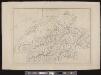
[Schweiz]
1 : 520000 1 Karte [Keller?], [Zürich?]
Helvetiae, Rhetiae & Valesiae com omnibus finitimis regionibus tabula vulgo Schweitzerland
1 : 700000 1 Karte apud Ioannem Ianssonium, Amstelodami
<<Die>> Schweiz
1 : 1025000 1 Karte entw. u. gez. von [Friedrich H.] Handke [i.e. Handtke] ; H. Müller lith. [Flemming], [Glogau]
Helvetiae, Rhetiae & Valesiae com omnibus finitimis regionibus tabula vulgo Schweitzerland
1 : 700000 1 Karte apud P. Schenk et G. Valk, Amstelodami
Carte de la Suisse ou Helvetie
1 : 695000 1 Karte dressée par [Pierre] Lapie et [Alexandre-Emile] Lapie fils ; la gravure dirigée par Lallemand chez Eymery Fruger et Cie., Paris
<<La>> Suisse
1 Karte par P. Du Val ; Somer sculp. et l'Alleman chez l'autheur, Paris
Helvetia tredecim statibus liberis quos cantones vocant, composita, una cum foederatis & subjectis provinciis
1 : 650000 1 Karte ex probatissimis subsidiis geographice delineata per Tobiam Mayerum luci publicae tradita ab Homannianis Heredibus, Norimbergae