Maps of Switzerland

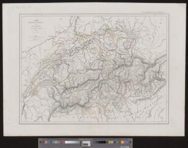
Carte physique et politique de la Suisse
1 : 1050000 1 Karte dréssée par L. Dussieux ; gravée par Martier [Lecoffre], [Paris]
Carte de la Suisse ou Helvetie
1 : 695000 1 Karte dressée par [Pierre] Lapie et [Alexandre-Emile] Lapie fils ; la gravure dirigée par Lallemand chez Eymery Fruger et Cie., Paris
General-Charte der Schweiz in XIX Cantone abgetheilt
1 : 1200000 1 Karte gez. u. gest. v. J. Scheurman bey Orell, Füssli und Compagnie, Zürich
Karte der Schweiz
1 : 650000 1 Karte entworfen und gestochen von J.H. Bachofen im Verlag J.H. Lochers, Zürich
<<Der>> Kriegsschauplatz in der Schweiz
1 : 1725000 1 Karte Lith. v. F. Malté [Allgemeine Zeitung], [Augsburg oder München]
Eswīğra
1 : 1000000 1 Karte [graviert, übersetzt und gedruckt von] ʿAlī Šaraf Pāšā Dar-e Saʿādat, Matbaʿ-e ʿĀmire, [İstanbul]
<<La>> Suisse
1 Karte par P. Du Val ; Somer sculp. et l'Alleman chez l'autheur en l'Isle du Palais sur le Quay de l'Horloge, Paris
<<Les>> XIII. cantons des Suisses, leurs alliéz et leurs sujets
1 : 1000000 1 Karte par N. de Fer ; C. Inselin sculpt. chez l'auteur dans l'Isle du Palais à la Sphère Royale, Paris
<<De>> Zwitsersche cantons, met hunne bontgenoten en onderdanen
1 : 1500000 1 Karte [Frans Halma], [Amsterdam]
<<Die>> Schweiz
1 : 1025000 1 Karte entw. u. gez. von [Friedrich H.] Handke [i.e. Handtke] ; H. Müller lith. [Flemming], [Glogau]
<<Les>> Suisses, leurs alliéz, avec les sujets des Suisses et des alliez
1 Karte selon les mémoires de Sjmler, de Gyger, et de plusieurs autres autheurs, par le Sr. Tillemon chez J.B. Nolin, Rue St-Jacques à l'enseigne de la Place des Victoires, Paris
<<La>> Suisse
1 Karte par P. Du Val ; Somer sculp. et l'Alleman chez l'autheur, Paris
<<Die>> schweiz. Abstimmung vom 12. Mai 1872
1 : 1250000 1 Karte [Verlag nicht ermittelbar], [Erscheinungsort nicht ermittelbar]
Helvetiae, Rhetiae & Valesiae com omnibus finitimis regionibus tabula vulgo Schweitzerland
1 : 700000 1 Karte apud P. Schenk et G. Valk, Amstelodami
1e. carte de Suisse
1 : 700000 1 Karte [par Jean Palairet] [chez Mess. J. Nourse & P. Vaillant dans le Strand], [Londres]
2e. carte de Suisse
1 : 700000 1 Karte [par Jean Palairet] [chez Mess. J. Nourse & P. Vaillant dans le Strand], [Londres]
Geologische Karte der Schweiz 1843
1 : 1210000 1 Karte gez. v. Max Daffner Verlag des Literarischen Comptoirs, Winterthur
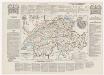
Switzerland and the country of the Grisons wherein is described the XIII Switz Cantons with their allies &c
1 Karte revised by I. Senex [Verlag nicht ermittelbar], [Erscheinungsort nicht ermittelbar]
General-Charte der Schweiz in XXII Cantone abgetheilt
1 : 1200000 1 Karte gez. u. gest. v. J. Scheurman bey Orell, Füssli und Compagnie, Zürich
Suisse
1 : 1500000 1 Karte [Verlag nicht ermittelbar], [Erscheinungsort nicht ermittelbar]
Tabula qua indicantur Confoederationis Helveticae loci in quibus tituli latini reperti sunt
1 : 1200000 1 Karte Topogr. Anstalt v. J. Wurster u. Comp., Winterthur
<<A>> new map of Swisserland
1 : 750000 1 Karte by John Cary printed for J. Cary, No. 181, Strand, London
594 S.
von Rudolf Hoernes
Von Veit, Leipzig

Politische Wahlkarte der Schweiz
1 : 1100000 1 Karte B.F. Haller, Berne
<<Die>> 19 Cantone der Vermittlungsakte von 1803-15
1 : 1700000 1 Karte Kartogr. Anstalt Hofer & Co., Zürich
Ansiedlung der Alamannen [und] Burgunder
1 : 1700000 1 Karte Kartogr. Anstalt Hofer & Co., Zürich
Helvetiae, Rhetiae & Valesiae com omnibus finitimis regionibus tabula vulgo Schweitzerland
1 : 700000 1 Karte apud Ioannem Ianssonium, Amstelodami
Carte générale physique et routière des 22 cantons de la confédération Suisse
1 : 750000 1 Karte par A.H. Brué ; gravée sous la direction de l'auteur ; les montagnes gravées par Dandeleux Brué, Paris
<<Die>> Schweitz oder Helvetien
1 : 1500000 1 Karte H. Keller fec. 1799 [Orell, Füssli und Compagnie], [Zürich]