Maps of Zurich

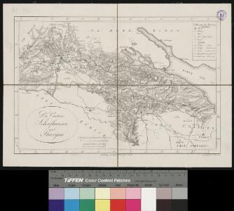
<<Die>> Cantone Schafhausen und Thurgau
1 : 260000 1 Karte gez. u. gest. von J. Scheurmann Orell Füssli & Cp., Zürich
<<Die>> Cantone Schafhausen und Thurgau
1 : 260000 1 Karte gez. u. gest. von J. Scheurmann Orell Füssli & Cp., Zürich
<<Die>> Cantone Schafhausen und Thurgau
1 : 260000 1 Karte gez. u. gest. von J. Scheurmann Orell, Füssli & Cp., Zürich
Atlas der Schweiz
1 : 450000 1 Atlas (18 Bl.) gez. u. gest. v. J. Scheurmann Orell Fussli, Zurich
Atlas de la Suisse
1 : 450000 1 Atlas (19 Bl.) dessiné par MM. H. Keller, Scheurmann, Pfyffer d'Altishofen, Osterwald, etc. ; gravé par M. Scheurmann Orell Füssli & Co., Zürich
<<Die>> Cantone Schaffhausen und Thurgau
1 : 260000 1 Karte gez. u. gest. von J. Scheurmann [Orell Füssli & Comp.], [Zürich]
Tabula topographica parochiarum sÿnodo Tigurinae ostrictarum opera
1 : 700000 1 Karte E.D. [i.e. Erhard Dürsteler] [Verlag nicht ermittelbar], [Zürich]
<<Die>> Cantone Schafhausen und Thurgau
1 : 260000 1 Karte gez. u. gest. von J. Scheurmann Orell, Füssli & Cp., Zürich
Distanzenkarte von der Schweiz
1 : 200000 1 Karte in 8 Teilen nach den besten Hülfsquellen bearb. von R. Huber Wagner, Bern
Tabula topographica parochiarum synodo Tigurinae obstrictarum
1 : 200000 1 Karte opera Joh. Heinr. Freytag, Chalcogr.
Cantone Zürich & Schaffhausen
1 : 410000 1 Karte R. Nick ft.
Tabula topographica parochiarum synodo Tigurinae obstrictarum opera
1 : 700000 1 Karte cura Joh. Hofmeister ; Tobias Lobeck sculp., Aug. Vin. [Johannes Hofmeister], [Zürich]
Tabula topographica parochiarum synodo Tigurinae obstrictarum
1 : 200000 1 Karte opera Joh. Heinr. Freytag, Chalcogr.
Suevia universa IX. tabulis delineata, 8
1 Blatt : s.n.
Tabula topographica parochiarum synodo Tigurinae obstrictarum opera
1 : 190000 1 Karte Joh. Heinr. Freytag
<<Die>> Eisenbahn-Linien in der nordöstlichen Schweiz
1 : 360000 1 Karte gez. von Rudolf Gross ; gest. von F. Melzl Füssli, Zürich
Tabula topographica parochiarum synodo tigurinæ obstrictarum
1 Karte : Kupferdruck ; 12 x 15 cm Hofmeister; Lobeck cura Joh. Hofmeisteri bibliop
Tigurini sive Tigurinus pagus in Helvetiis
1 : 200000 1 Karte par Sanson = Le Zurichgow en Suisse et dans l'evesche de Constance chez P. Mariette, Paris
Darstellung von Stadt und Landschaft Zürich nach Kapiteln der Zürcher Synode
1 : 250000 Originaltitel: Tabula topographica parochiarum synodo Tigurina. Mit farbigen Wappen der innern und äussern Vogteien, einer Nebenkarte der Herrschaft Sax-Forstegg, zwei angeklebten Ergänzungskarten (Thurgau/Bodensee und Rheintal) sowie Legende. Ohne Datumsangabe (Datierung gemäss Angabe von Hans Jakob Holzhalb in: Supplement zu dem allgemeinen helvetisch-eidgenössischen oder schweizerischen Lexicon, so von weiland Herrn Hans Jakob Leu, Bürgermeister Löbl. Freystaats Zürich, in alphabetischer Ordnung behandelt worden, Band 2, S. 360). Freytag, Johann Heinrich, Kupferstecher
Karte des Kantons Thurgau
1 : 200000 1 Karte J.S. Gerster ; Zeichnung, Stich und Druck v. Wurster, Randegger & Co. Wurster, Randegger & Cie., Winterthur
<<Die>> Land-Grafschafft Thurgeu und allen darin ligenten Herrschafften, wie auch der Städten, Clösteren, Schlösseren, Ritter Freysitze und angränzenten Land-Schafften
1 : 200000 1 Karte [gegrab. von I.G. Sturm] ; D.H. [i.e. David Herrliberger] exc. [Herrliberger], [Zürich?]
Militärkarte der Nordostschweiz
1 : 52000 Originaltitel: Der Uralten Loblichen Statt Zürich Graffschaften, Herrschaften, Stett und Land diser zyt von ihnen beherrschet, auch derselben benachbarte verbündet und angehörige, und inen sonst mit Burgrecht und Eigenschafft zugethan als Appenzell, Apt und Statt S. Gallen, die Grafschafften Turgow, Baden, Toggenburg, Sargans, Windegg, Werdenberg und das Rhynthal. So by uralten Zyten in pagum Tigurinum gedient, an ietzo aber in andrem stand und wesen sind, ihr allerseits orth und glegenheit in grund gelegt und lebendig vor augen gestelt. Anno 1620. Die Karte und ausführliche Erläuterungen, das Defensional von Hans Haller, wurden am 11.10.1620 dem Rat von Zürich übergeben. Aufnahme: Nüscheler, Christoph (1589-1661), Glas- und Flachmaler sowie Quartiermeister, von Zürich; Nüscheler, Hans Jakob (1583-1654), Glas- und Flachmaler sowie Quartiermeister, von Zürich; Oeri, Hans, Quartiermeister; Ringgli, Gebhard, Quartiermeister; Haldenstein, Hans Ulrich, Quartiermeister; Gyger, Hans Conrad, andere Schreibweisen: Geiger, Geyger, (1599-1674), Kartograf, Ingenieur und Quartiermeister, von Zürich; Haller, Hans, Stadtingenieur; Bürkli, Jakob, Stadtingenieur Zeichnung: Gyger, Hans Conrad, andere Schreibweisen: Geiger, Geyger, (1599-1674), Kartograf und Ingenieur, von Zürich
<<Der>> Canton Zürich
1 : 230000 1 Karte J.J. Scheurmann sc.
Tabula topographica parochiarum synodo Tigurinae obstrictarum
1 : 200000 1 Karte opera Joh. Heinr. Freytag, Chalcogr.
Karte der Landgrafschaft Thurgau samt angrenzenden Herrschaften
1 : 52000 Vereinfachte handgezeichnete Kopie der im Jahr 1628 von Johannes Murer (1556-1641), Pfarrer in Rickenbach und Dekan des Winterthurer Pfarrkapitels, sowie Hans Caspar Huber, früherer Landvogt der Herrschaft Pfyn, in Auftrag gegebenen und von Hans Conrad Gyger (1599-1674), Kartograf und Ingenieur, von Zürich, verfertigten Originalkarte. Mit Legenden und biografischen Angaben über Johannes Murer, mit Wappen der regierenden Orte sowie mit Ansicht von Frauenfeld. Wagner, Johann Jakob (1641-1695), Stadtarzt von Zürich und naturwissenschaftlicher Forscher, von Zürich
Tabula topographica parochiarum synodo Tigurinae obstrictarum opera
1 : 190000 1 Karte Joh. Heinr. Freytag
Karte des Kantons Zürich
1 : 250000 1 Karte
Tabula topographica parochiarum synodo Tigurinae obstrictarum opera
1 : 190000 1 Karte Joh. Heinr. Freytag
Zürich Gebiet
1 : 250000 1 Karte J.H. Streulinus inv. ; J.G. Seiller sculpsit