Maps of Waldenburg

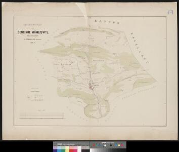
Uebersichtsplan der Gemeinde Mümliswyl
1 : 10000 1 Karte aufgenommen durch L. Pfändler 1869-71 Topograph. Anstalt v. Wurster, Randegger & Co., Winterthur
Uebersichtsplan der Gemeinde Balsthal
1 : 10000 Feller, Karl Topogr. Anstalt v. Wurster, Randegger & Cie.
Uebersichtsplan der Gemeinde Laupersdorf
1 : 10000 1 Plan aufgenommen durch K. Feller 1871-72 Topogr. Anstalt v. Wurster, Randegger & Co., Winterthur
Uebersichtsplan der Gemeinde Laupersdorf
1 : 10000 Feller, Karl Topogr. Anstalt v. Wurster, Randegger & Co.
Führer und Exkursions-Karte für Solothurn und Umgebung
1 : 100000 1:100 000 Verkehrs- und Verschönerungs-Verein Solothurn Verkehrs- und Verschönerungs-Verein Solothurn
Carte typométrique du Canton de Basle
1 Karte : Typometrie ; 20 x 19 cm Haas Wilhelm Haas
Karte vom Canton Basel
1 : 50000 Kündig, Andreas C. Detloff
Karte vom Canton Basel
1 : 50000 Kündig, Andreas C. Detloff
Karte vom Canton Basel
1 : 50000 Südwest-Blatt Müller, Albrecht ; Kündig, Andreas Wurster & Cie.
Ammt Waldenburg
1 : 48000 1 Karte Em. Büchel del. ; Io. Rod. Holzhalb sc. [Verlag nicht ermittelbar], [Basel]
Ammt Waldenburg
1 Karte : Kupferdruck ; 19 x 19 cm Büchel; Holzhalb s.n.
Uebersichtsplan der Gemeinden Aedermannsdorf und Matzendorf
1 : 10000 1 Plan aufgenommen durch K. Feller 1872-73 Topogr. Anstalt von Wurster, Randegger & Co., Winterthur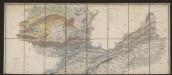
Carte des Cantons Solothurn
1 : 60000 Nordblatt Walker, Josef Engelmann & Compagnie
Wandkarte von Basel und Umgebung
1 : 50000 1 Karte in 4 Teilen bearbeitet von J. Randegger Carl Detloff, Basel
Atlas novus Reipublicae Helveticae
1 Atlas ([40] Bl., 97 S.) bey Orell, Gessner und Compagnie, Zürich
Canton Basel sive Pagus Helvetiae Basileensis cum confinibus recenter
1 : 70000 Mollova mapová sbírka Walser, Gabriel Homann, Johann Baptista - dědici

Karte vom Canton Basel
1 : 50000 1 Karte auf 4 Bl. entworfen von Andreas Kündig im Verlag von C. Detloff in Basel ; geologisch aufgenommen u. dargestellt von Albr. Müller in Basel 1862 Wurster & Cie., Winterthur
Canton Solothurn Sive Pagus Helvetiae Solodurensis cum Confinibus recenter delineatus
1 : 110000 Mollova mapová sbírka Walser, Gabriel Homann, Johann Baptista - dědici
Karte der Kantone Baselland und Baselstadt
1 : 100000 1 Karte von J.S. Gerster ; auf Anordnung der h. Erziehungsdirection von Baselland ; Zeichnung, Stich u. Druck von Wurster, Randegger & Cie. in Winterthur Wurster, Randegger & Cie., Winterthur
Der Canton Basel mit den angränzenden Bezirken
1 : 79000 Basilej-oblast (Švýcarsko) Diewald, Johann Nepomuk Bruckner bey Homanns Erben
Canton Solothurn sive pagus Helvetiae Solodurensis cum confinibus
1 : 134500 Solothurn (Švýcarsko : kanton) Walser, Gabriel edentibus Homann. Heredib[us]
Canton Solothurn sive pagus Helvetiae Solodurensis cum confinibus
1 Karte : Kupferdruck ; 46 x 55 cm Walser Homann. Heredibus
Canton Solothurn sive pagus Helvetiae Solodurensis cum confinibus
1 Karte : Kupferdruck ; 46 x 55 cm Walser Homann. Heredibus
Canton Solothurn sive pagus Helvetiae Solodurensis cum confinibus
1 Karte : Kupferdruck ; 23 x 25 cm Walser Homännische Erben
Geographica Provinciarum Sveviae Descriptio =
Mollova mapová sbírka Hurter, Johann Christoph Bodenehr, Gabriel
Archäologische Karte des Kantons Solothurn
1 : 100000 Heierli, Jakob Petri
Lauf des Birs-Flusses von seinem Vrsprung an bis an seinen Ausfluss in den Rhein
1 Karte : Kupferdruck ; 27 x 14 cm Herrliberger; Büchel D. Herrliberger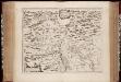
Territorivm Basileense, cum adjacentibus
1 : 140000 Annotatie: Verso UB VU-exemplaar is blanco; Origineel is Blad 115 in atlas factice; Annotatie geografische gegevens: Schaalstok linksonder; Zuid boven Joan Blaeu 1597/98-1673 [Amstelædami, labore & sumptibus : Ioannis Blaev]