Maps of Zurich

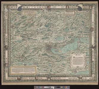
Eigentliche Verzeichnuss der Städten, und Graffschaften und Herrschaften, welche in der Stadt Zürich-Gebiet und Landschaft gehörig sind
1 : 56000 1 Karte auf 16 Bl. gerissen durch Josen Murern
Eigentliche Verzeichnung der Städten, und Graffschaften, und Herrschaften, welche in der Stadt Zürich Gebiet und Landschaft gehörig sind
1 : 56000 1 Karte auf 16 Bl. gerissen durch Josen Murer
Karte des Zürcher Gebiets (Murer-Karte) von 1566
1 : 56000 Originaltitel: Eigentliche Verzeichnung der Städten, und Graffschaften, und Herrschaften, welche in der Stadt Zürich Gebiet und Landschaft gehörig sind. Neudruck (vermutlich 8. Auflage) der von Jos Murer verfertigten Originalkarte. Mit Legenden. Druck und Verlag: Orell, Füssli und Cie., in Zürich
[Eigentliche Verzeichnuss der Städten, Graffschafften und Herrschafften, welche in der Stadt Zürich-Gebiet und Landschafft gehörig sind]
1 : 56000 1 Karte auf 16 Bl. [gerissen durch Josen Murern]
Karte des Zürcher Gebiets
1 : 96000 Originaltitel: Nova descriptio ditionis Tigurinae, Regionumque finitimarum, Neüe beschreibung der Landschafft Zürich. Im Kupferdruck veröffentlichte verkleinerte und inhaltlich vereinfachte, auf sechs Blätter aufgeteilte Kopie der Grossen Landtafel des Zürcher Gebiets (Gyger-Karte) von 1667. Enthält Nebenkarte der Freiherrschaft Sax-Forstegg sowie bildliche Darstellung der einzelnen Vogteischlösser, der Wappen der Inneren Vogteien, ferner der Stadt Zürich sowie der damaligen männlichen und weiblichen Bekleidung. Herausgeber: Gyger, Hans Georg (1627-1687), Maler und Amtmann des Klosteramts Küsnacht, von Zürich Zeichnung: Gyger, Hans Conrad, andere Schreibweisen: Geiger, Geyger, (1599-1674), Kartograf, Ingenieur und Amtmann des Amts Kappelerhof, von Zürich Stich: Meyer, Johannes (1655-1712), Kupferstecher, von Zürich
Karte des Zürcher Gebiets von 1685
1 : 96000 Neudruck der von Hans Georg Gyger (1627-1687), Maler und Amtmann des Klosteramts Küsnacht, von Zürich, herausgegebenen Originalkarte. Mit vereinzelten - wohl nachträglich angebrachten - Kolorierungen. Ohne Datumsangabe. Druck und Verlag: Hiltensperger, Johann Jost (1711-1792), Kupferstecher und Formschneider, in Zug
Nova et accurata Agri Tigurini cum confiniis tabula geographica
1 : 200000 1 Karte ex cel. Scheuchzeri et Gygeri observationibus ; constructa a J. Heinrich Freytag
Delineatio aller Quartieren der Statt und Landschaft Zürich
1 : 200000 1 Karte von Joh. Heinr. Freytag
Darstellung von Stadt und Landschaft Zürich nach Quartieren
1 : 250000 Originaltitel: Delineatio aller Quartieren der Statt und Landschaft Zürich. Mit farbigen Wappen der innern und äussern Vogteien, einer Nebenkarte der Herrschaft Sax-Forstegg, ferner Legende. Ohne Datumsangabe (Datierung gemäss Angabe der Zentralbibliothek Zürich). Freytag, Johann Heinrich, Kupferstecher
Nova et accurata Agri Tigurini cum confiniis tabula geographica
1 : 200000 1 Karte ex cel. Scheuchzeri et Gygeri observationibus ; [gezeichnet von Joh. Balthasar Bullinger] ; constructa a J. Heinrich Freytag, Chalcographo
Delineatio aller Quartieren der Statt und Landschaft Zürich
1 : 200000 1 Karte von Joh. Heinr. Freytag
Nova et accurata Agri Tigurini cum confiniis tabula geographica
1 : 200000 1 Karte ex cel. Scheuchzeri et Gygeri observationibus ; [gezeichnet von Joh. Balthasar Bullinger] ; constructa a J. Heinrich Freytag, Chalcographo
<<Der>> Canton Zürich
1 : 335000 1 Karte gezeichnet und verlegt von H. Keller
Nova descriptio ditionis Tigurinae regionumque finitimarum
1 : 95000 1 Karte Joh. Conradus Gygerus, P. delineavit ; Joh. Georgius Gygerus, F. in aes incidi ; curavit per Johannem Meyerum Ao. 1685
Grosse Landtafel des Zürcher Gebiets: Esquelette der Zürcher Kantonskarte in 56 Blättern
Später eingefügte Blattübersicht von Johannes Müller. Müller, Johannes (1733-1816), obrigkeitlicher Ingenieur des Zürcher Stadtstaats, von Zürich
Darstellung von Stadt und Landschaft Zürich nach Vogteien
1 : 250000 Originaltitel: Nova et accurata Agri Tigurini cum confiniis tabula geographica. Beruht auf der Gyger-Karte von 1667. Mit farbigen Wappen der innern und äussern Vogteien, einer Nebenkarte der Herrschaft Sax-Forstegg, ferner Legende. Ohne Datumsangabe (Datierung gemäss Angabe der Zentralbibliothek Zürich). Freytag, Johann Heinrich, Kupferstecher
Delineatio Pagi Tigurini ex observationibus recentissimis et accuratissimis
1 : 150000 1 Karte sculpsit et excudit Matth. Seutter ; Tob. Conr. Lotter sculps.
Tabula topographica parochiarum synodo Tigurinae obstrictarum opera
1 : 190000 1 Karte Joh. Heinr. Freytag
Zürich Gebiet
1 : 250000 1 Karte J.H. Streulinus inv. ; J.G. Seiller sculpsit
Karte des Kantons Zürich
1 : 250000 1 Karte
Delineatio aller Quartieren der Statt und Landschaft Zürich
1 : 190000 1 Karte von Joh. Heinr. Freytag
Karte vom Canton Zürich 1795
1 : 600000 1 Karte M.P. f.
Delineatio aller Quartieren der Statt und Landschaft Zürich
1 : 190000 1 Karte von Joh. Heinr. Freytag
Zürich Gebiet
1 : 250000 1 Karte J.H. Streulinus inv. ; J.G. Seiller sculpsit
Militärkarte der Nordostschweiz
1 : 52000 Originaltitel: Der Uralten Loblichen Statt Zürich Graffschaften, Herrschaften, Stett und Land diser zyt von ihnen beherrschet, auch derselben benachbarte verbündet und angehörige, und inen sonst mit Burgrecht und Eigenschafft zugethan als Appenzell, Apt und Statt S. Gallen, die Grafschafften Turgow, Baden, Toggenburg, Sargans, Windegg, Werdenberg und das Rhynthal. So by uralten Zyten in pagum Tigurinum gedient, an ietzo aber in andrem stand und wesen sind, ihr allerseits orth und glegenheit in grund gelegt und lebendig vor augen gestelt. Anno 1620. Die Karte und ausführliche Erläuterungen, das Defensional von Hans Haller, wurden am 11.10.1620 dem Rat von Zürich übergeben. Aufnahme: Nüscheler, Christoph (1589-1661), Glas- und Flachmaler sowie Quartiermeister, von Zürich; Nüscheler, Hans Jakob (1583-1654), Glas- und Flachmaler sowie Quartiermeister, von Zürich; Oeri, Hans, Quartiermeister; Ringgli, Gebhard, Quartiermeister; Haldenstein, Hans Ulrich, Quartiermeister; Gyger, Hans Conrad, andere Schreibweisen: Geiger, Geyger, (1599-1674), Kartograf, Ingenieur und Quartiermeister, von Zürich; Haller, Hans, Stadtingenieur; Bürkli, Jakob, Stadtingenieur Zeichnung: Gyger, Hans Conrad, andere Schreibweisen: Geiger, Geyger, (1599-1674), Kartograf und Ingenieur, von Zürich
Tabula topographica parochiarum synodo Tigurinae obstrictarum
1 : 200000 1 Karte opera Joh. Heinr. Freytag, Chalcogr.
Neue und exakte geographische Tabelle der Gebiete der Stadt Zürich
1 : 740000 Originaltitel: Neue und Exacte Geograph. Tabell von der Statt Zürich gebiett nach derselben inneren und ausseren habenden Vogteyen eingerichtett. Mit Wappen der Vogteien. Zeichnung und Stich: Lobeck, Tobias Verlag: Hofmeister, Johannes, Buchbinder, in Zürich
Tabula topographica parochiarum synodo Tigurinae obstrictarum
1 : 200000 1 Karte opera Joh. Heinr. Freytag, Chalcogr.
Tabula topographica parochiarum synodo Tigurinae obstrictarum
1 : 200000 1 Karte opera Joh. Heinr. Freytag, Chalcogr.