Maps of Grisons

Atlas novus Reipublicae Helveticae
1 Atlas ([40] Bl., 97 S.) bey Orell, Gessner und Compagnie, Zürich
<<Der>> Canton Graubünden
1 : 470000 1 Karte R. am Stein delin. ; Scheurmann sculp. [Orell Füssli & Cp.?], [Zürich?]
Karte des Kantons Graubündten [i.e. Graubünden]
1 : 250000 1 Karte Topogr. Anstalt Winterthur, J. Schlumpf Geographisches Institut J. Meier, Zürich
Graubünden
1 : 1450000 [Stumme Kartenskizzen der ganzen Schweiz und der einzelnen Kantone zu Unterrichtszwecken] Schulbuchhandlung Antenen
<<Der>> Canton Graubünden
1 : 470000 1 Karte R. am Stein delin. ; Scheurmann sculp. [Orell Füssli & Cp.], [Zürich]
<<Der>> Canton Graubündten [i.e. Graubünden]
1 : 470000 1 Karte R. am Stein delin. ; Scheurmann sculp. [Orell Füssli & Comp.], [Zürich]
<<Der>> Kanton Graubünden
1 : 460000 1 Karte gez. von Rud. Gross Verlag von Ch. Beÿel, Zürich
<<Der>> Canton Graubünden
1 : 470000 1 Karte R. am Stein delin. ; Scheurmann sculp. [Orell Füssli & Cp.], [Zürich]
Atlas de la Suisse
1 : 450000 1 Atlas (19 Bl.) dessiné par MM. H. Keller, Scheurmann, Pfyffer d'Altishofen, Osterwald, etc. ; gravé par M. Scheurmann Orell Füssli & Co., Zürich
<<Der>> Canton Graubünden
1 : 470000 1 Karte R. am Stein delin. ; Scheurmann sculp. [Orell Füssli & Cp.?], [Zürich?]
<<Der>> Canton Graubünden
1 : 470000 1 Karte R. am Stein delin. ; Scheurmann sculp. [Orell Füssli], [Zürich]
Karte des Kantons Graubundten [i.e. Graubünden]
1 : 250000 1 Karte J. Wurster u. Comp., Winterthur
Karte des Kantons Graubünden
1 : 250000 1 Karte Joh. Wurster & Comp., Winterthur
<<Der>> Canton Graubünden
1 : 470000 1 Karte R. am Stein delin. ; Scheurmann sculp. [Orell Füssli & Cp.], [Zürich]
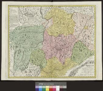
Rhaetia Foederata cum Confinibus et Subditis suis Valle Telina, Comitatu Clavennensi et Bormiensi, recenter et accuratißimé delineata
1 : 320000 Mollova mapová sbírka Walser, Gabriel Silbereisen, Andreas Seutter, Matthäus
<<Der>> Canton Graubünden
1 : 470000 1 Karte R. am Stein delin. ; Scheurmann sculp. [Orell Füssli], [Zürich]
Reisekarte von Graubünden, Schweiz
1 : 300000 Graubünden (Švýcarsko) Direktion der Rhätischen Bahn
Alpinae seu Foederatae Rhaetiae Subditarumque ei Terrarum nova descriptio. [Karte], in: Gerardi Mercatoris et I. Hondii Newer Atlas, oder, Grosses Weltbuch, Bd. 1, S. 268.
1 Karte aus Atlas Mercator, Gerhard und Hondius, Jodocus Jansson, Jan
Alpinae seu Foederatae Rhaetiae Subditarumque ei Terrarum nova descriptio. [Karte], in: Novus Atlas, das ist, Weltbeschreibung, Bd. 1, S. 248.
1 Karte aus Atlas Blaeu, Joan Blaeu, Willem Janszoon
Nova Rhaetiae atque totius Helvetiae descriptio
1 : 350000 1 Karte auf 10 Bl. per Aegidium Tschudum Glaronensem Hofer & Burger, Zürich
Alpinae seu Foederatae Rhaetiae Subditarumque ei Terrarum nova descriptio. [Karte], in: Novus atlas absolutissimus, Bd. 4, S. 251.
1 Karte aus Atlas Janssonius Offizin
[Kaart], uit: Reisekarte von Graubünden, Schweiz / Kümmerly & Frey
1 : 300000 Kümmerly + Frey, Bern Chur : Direktion der Rhätischen Bahn
Carte du réseau télégraphique Suisse
1 : 250000 Ostblatt Schweizerische Telegraphen- und Telephonverwaltung Kartographische Anstalt LIPS
[Exactissima Helvetiae, Rhaetiae, Valesiae ... tabula]
1 : 850000 9 Karten [Kopie von Adrian Braakman] [chez Pierre Schenk et Adrian Braakman], [Amsterdam]
Nova Helvetiae tabula geographica illustrissimis et potentissimis cantonibus et rebuspublicis reformatae religionis Tigurinae, Bernensi, Glaronensi, Basiliensi, Scaphusianae, Abbatis Cellanae
1 : 230000 1 Karte auf 4 Bl. dominis suis clementissimis humillime dicata a Ioh. Iacobo Scheuchzero Tigurino ; Ioh. Melch. Füsslin ornamenta pinx. ; Ioh. Henr. Huber et Eman. Schalch sculps. [Hofmeister], [Zürich]
Nova Helvetiae tabula geographica illustrissimis et potentissimis cantonibus et rebuspublicis reformatae religionis Tigurinae, Bernensi, Glaronensi, Basiliensi, Scaphusianae, Abbatis Cellanae
1 : 230000 1 Karte auf 4 Bl. dominis suis clementissimis humillime dicata a Ioh. Iacobo Scheuchzero Tigurino ; Ioh. Melch. Füsslin ornamenta pinx. ; Ioh. Henr. Huber et Eman. Schalch sculps. [Verlag nicht ermittelbar], [Zürich]
Alpinæ seu Foederatæ | RHAETIAE | SUBDITARUMQUE | ei Terrarum nova | descriptio
Auctoribus | Fortunato Sprechero à Berneck, Eq. aur. & I.V.D. Ret. | Ac PHIL. CLUVERIO. Evert Sijmons Z. | Hamers Veldt sculp. Amstelodami | Apud Judocum | Hondium
Atlas der alten Eidgenossenschaft in 20 Karten: Freistaat Gemeiner Drei Bünde (Gotteshausbund, Grauer Bund, Zehngerichtenbund) und zugewandter Ort der Eidgenossenschaft
Originaltitel: Rhaetia Foederata cum Confinus et Subditis suis Vale Telina, Comitatu Clavennensi et Bormiensi. Mit Erklärung der Zeichen. Neue Zeichnung: Walser, Gabriel (1695-1776), reformierter Pfarrer, von Teufen AR Herausgeber: Homännische Erben
Alpinae seu Foederatae Rhaetiae Subditarumque ei Terrarum nova descriptio. [Karte], in: Le théâtre du monde, ou, Nouvel atlas contenant les chartes et descriptions de tous les païs de la terre, Bd. 1, S. 279.
1 Karte aus Atlas Blaeu, Willem Janszoon und Blaeu, Joan Blaeu, Willem Janszoon