Maps of Thurgau

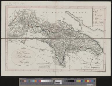
<<Die>> Cantone Schafhausen und Thurgau
1 : 260000 1 Karte gez. u. gest. von J. Scheurmann Orell, Füssli & Cp., Zürich
<<Die>> Cantone Schafhausen und Thurgau
1 : 260000 1 Karte gez. u. gest. von J. Scheurmann Orell Füssli & Cp., Zürich
<<Die>> Cantone Schafhausen und Thurgau
1 : 260000 1 Karte gez. u. gest. von J. Scheurmann Orell Füssli & Cp., Zürich
<<Die>> Cantone Schafhausen und Thurgau
1 : 260000 1 Karte gez. u. gest. von J. Scheurmann Orell, Füssli & Cp., Zürich
Atlas der Schweiz
1 : 450000 1 Atlas (18 Bl.) gez. u. gest. v. J. Scheurmann Orell Fussli, Zurich
Atlas de la Suisse
1 : 450000 1 Atlas (19 Bl.) dessiné par MM. H. Keller, Scheurmann, Pfyffer d'Altishofen, Osterwald, etc. ; gravé par M. Scheurmann Orell Füssli & Co., Zürich
<<Die>> Cantone Schaffhausen und Thurgau
1 : 260000 1 Karte gez. u. gest. von J. Scheurmann [Orell Füssli & Comp.], [Zürich]
Tabula topographica parochiarum sÿnodo Tigurinae ostrictarum opera
1 : 700000 1 Karte E.D. [i.e. Erhard Dürsteler] [Verlag nicht ermittelbar], [Zürich]
Tabula topographica parochiarum synodo tigurinæ obstrictarum
1 Karte : Kupferdruck ; 12 x 15 cm Hofmeister; Lobeck cura Joh. Hofmeisteri bibliop
Karte der Landgrafschaft Thurgau samt angrenzenden Herrschaften
1 : 52000 Vereinfachte handgezeichnete Kopie der im Jahr 1628 von Johannes Murer (1556-1641), Pfarrer in Rickenbach und Dekan des Winterthurer Pfarrkapitels, sowie Hans Caspar Huber, früherer Landvogt der Herrschaft Pfyn, in Auftrag gegebenen und von Hans Conrad Gyger (1599-1674), Kartograf und Ingenieur, von Zürich, verfertigten Originalkarte. Mit Legenden und biografischen Angaben über Johannes Murer, mit Wappen der regierenden Orte sowie mit Ansicht von Frauenfeld. Wagner, Johann Jakob (1641-1695), Stadtarzt von Zürich und naturwissenschaftlicher Forscher, von Zürich
Projektierte Eisenbahnstrecke Winterthur-Singen-Kreuzlingen; Übersichtskarte
1 : 250000 Mit Legende. Ohne Datumsangabe. Wurster, Randegger und Cie., in Winterthur
Tabula topographica parochiarum synodo Tigurinae obstrictarum opera
1 : 190000 1 Karte Joh. Heinr. Freytag
Suevia universa IX. tabulis delineata, 8
1 Blatt : s.n.
Atlas Suisse
1 : 120000 16 Karten levé et dessiné par J.H. Weiss [et Joachim Eugen Müller] aux frais de J.R. Meyer à Aarau dans les années 1786 à 1802 ; gravée [sic] par [Christophe] Guérin, [Matthias Gottfried] Eichler et [Johann Jakob] Scheurmann [Johann Rudolf Meyer], Aarau
<<Die>> Eisenbahn-Linien in der nordöstlichen Schweiz
1 : 360000 1 Karte gez. von Rudolf Gross ; gest. von F. Melzl Füssli, Zürich
Darstellung von Stadt und Landschaft Zürich nach Kapiteln der Zürcher Synode
1 : 250000 Originaltitel: Tabula topographica parochiarum synodo Tigurina. Mit farbigen Wappen der innern und äussern Vogteien, einer Nebenkarte der Herrschaft Sax-Forstegg, zwei angeklebten Ergänzungskarten (Thurgau/Bodensee und Rheintal) sowie Legende. Ohne Datumsangabe (Datierung gemäss Angabe von Hans Jakob Holzhalb in: Supplement zu dem allgemeinen helvetisch-eidgenössischen oder schweizerischen Lexicon, so von weiland Herrn Hans Jakob Leu, Bürgermeister Löbl. Freystaats Zürich, in alphabetischer Ordnung behandelt worden, Band 2, S. 360). Freytag, Johann Heinrich, Kupferstecher
<<Der>> Canton Zürich
1 : 230000 1 Karte J.J. Scheurmann sc.
Zürich Gebiet
1 Karte : Kupferdruck ; 27 x 26 cm Streuli; Seiller J.H. Streulin?
Suevia Universa :
1 : 170000 Mollova mapová sbírka Michal, Jacques de Seutter, Matthäus Seutter, Matthäus
Tigurini sive Tigurinus pagus in Helvetiis
1 : 200000 1 Karte par Sanson = Le Zurichgow en Suisse et dans l'evesche de Constance chez P. Mariette, Paris
Carte topographique d'Allemagne
1 : 218000 Appenzell- Ausserrhoden (Švýcarsko : kanton) Jaeger, Johann Wilhelm Abraham chez I.W.A. Iaeger
Carte topographique d'Allemagne
1 : 218000 Appenzell- Ausserrhoden (Švýcarsko : kanton) Jaeger, Johann Wilhelm Abraham I. W. A. Iaeger
Karte des Kantons Thurgau
1 : 200000 1 Karte J.S. Gerster ; Zeichnung, Stich und Druck v. Wurster, Randegger & Co. Wurster, Randegger & Cie., Winterthur
Karte des Kantons Zürich
1 : 250000 1 Karte
Verbreitung des Cretinismus, des Blödsinns und der Taubstummheit
1 : 150000 1 Karte bey Heinr. Fuessli & Co., Zürich
<<Die>> Land-Grafschafft Thurgeu und allen darin ligenten Herrschafften, wie auch der Städten, Clösteren, Schlösseren, Ritter Freysitze und angränzenten Land-Schafften
1 : 200000 1 Karte [gegrab. von I.G. Sturm] ; D.H. [i.e. David Herrliberger] exc. [Herrliberger], [Zürich?]
Carte des Cantons Thurgau
1 : 150000 1 Karte trigonometrische Aufnahme [Johann Jakob] Sulzberger ; [Rinaldo] Bressanini sc. bey Heinr. Fuessli & Co., Zürich
Karte der Landgrafschaft Thurgau
Originaltitel: Die Land-Grafschafft Thurgeu, und allen darin ligenten Herrschafften, wie auch der Städten, Clösteren, Schlösseren, Ritter Freysitze und angränzenten Land-Schafften. Mit Erklärung der Farben und Zeichen sowie einer Nebenkarte von Rheinau. D. H.
<<Die>> Cantone Schaffhausen und Thurgau
1 : 260000 1 Karte gez. u. gest. von J. Scheurmann [Orell Füssli & Comp.], [Zürich]