Maps of Zermatt

Domo d'Ossola, Arona
1 : 100000 1 Karte geolog. Aufnahmen von H. Gerlach [Wurster & Randegger], [Winterthur]
Blatt XXIII: Domo d'Ossola, Arona, uit: Topographische Karte der Schweiz / vermessen und hrsg. ... unter Aufsicht des Generals G.H. Dufour
1 : 100000 Annotatie: Met plaatsnamenregister (bl. V), bladwijzer (bl. XXI) en hoogteregister (bl. XXV); Voor aanwezige bladen zie overzichtsblad Dufour, G. H. [Bern : Eidg. Topogr. Bureau]
Topographische Karte der Schweiz
1 : 100000 25 Karten vermessen und hrsg. auf Befehl der Eidgenössischen Behörden ; aufgenommen unter der Aufsicht des Generals G.H. Dufour Eidg. Topographisches Bureau, [Genève], [später: Bern]
[Monte Rosu und Umgebung]
1 : 250000 Alpy italské (pohoří) Wagner & Debes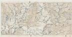
[Kaart], uit: Theodulpass
1 : 50000 Bern : Schweizerische Landestopographie
Süd-Wallis
1 : 50000 8 Karten Topogr. Anstalt v. Wurster, Randegger & Co. ; gestochen von R. Leuzinger Topogr. Anstalt v. Wurster, Randegger & Co., Winterthur
M[on]te Rosa
1 : 50000 Penninské Alpy (Itálie a Švýcarsko : pohoří) A. Vallardi
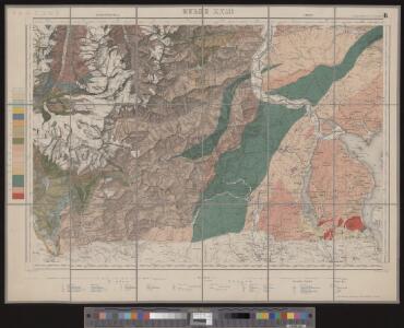
Reliefkarte des Saas- und Monte Morogebietes
1 : 50000 1 Karte nach den Blättern 534 u. 536 des Siegfried Atlasses bearbeitet von R. Leuzinger ; Eidg. topogr. Bureau 1881 ; Topogr. Anst. v. Wurster, Randegger & Cie. [Verlag der Expedition des Jahrbuches des S.A.C.], [Bern]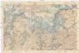
Il Cervino e il Monte Rosa
1 : 50000 Penninské Alpy (Itálie a Švýcarsko : pohoří) Touring club Italiano
[Kaart], uit: Carte d'excursions de Zermatt
1 : 50000 Annotatie: Omslagtitel in het Duits en Frans, toeristische informatie in het Duits; Verso: toeristische informatie en hotels Seiler Zürich : Hofer & Co
Carte d'excursions de Zermatt
1 : 50000 Hofer & Co.
Süd-Wallis
1 : 50000 8 Karten Topogr. Anstalt v. Wurster, Randegger & Co. ; gestochen von R. Leuzinger Topogr. Anstalt v. Wurster, Randegger & Co., Winterthur
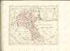
Biella
1 : 200000 Herder, Bartholomew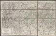
Viaggio ai tre laghi
1 : 188000 Stucchi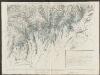
Partie du c.ton du Vallais et le versant des eaux du Piemont
1 : 108000 Weiss, Johann Heinrich ; Guérin, Christophe ; Meyer, Johann Rudolf J. R. Meyer
Zermatt, Mte. Rosa
1 Vogelschaukarte Orell Füssli, Zürich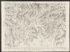
Majeure partie des cantons de Bellinzona et de Lugano et les frontières de la République Italienne
1 : 108000 Weiss, Johann Heinrich ; Guérin, Christophe ; Meyer, Johann Rudolf J. R. Meyer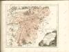

Karte über einen Theil der südlichen Wallisthäler
1 : 100000 1 Karte frei gezeichnet nach topogr. Skitzen ... von G. Studer 1849 Heinrich Fuessli u. Comp. zur Meisen, Zürich
[Lago Maggiore und Umgebung]
1 : 250000 Alpy italské (pohoří) Wagner & Debes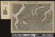
Lugano
1 Vogelschaukarte Orell Füssli, Zürich
Karte über einen Theil der südlichen Wallisthäler
1 : 100000 Studer, Gottlieb Henry Heinrich Fuessli u. Comp. zur Meisen
Schulwandkarte zur Geschichte der Schweiz
1 : 180000 Südblatt Oechsli, Wilhelm ; Baldamus, Alfred Kartograph. Verlagsanstalt von Georg Lang
Biella
1 : 200000 1 Karte entworfen und bearbeitet von Woerl ; in Stein gestochen unter seiner Leitung 1835 ; Lithographie von B. Herder Herder, Freiburg im Breisgau
<<Der>> Canton Wallis
1 : 450000 1 Karte gez. u. gest. v. J. Scheuermann Orell Füssli & Comp., Zürich
Nova Rhaetiae atque totius Helvetiae descriptio
1 : 350000 1 Karte auf 10 Bl. per Aegidium Tschudum Glaronensem Hofer & Burger, Zürich
Schulwandkarte zur Geschichte der Schweiz
1 : 180000 1 Karte auf 6 Bl. bearbeitet v. W. Oechsli u. A. Baldamus ; gezeichnet von Ed. Gaebler Kartograph. Verlagsanstalt von Georg Lang, Leipzig
<<Der>> Canton Wallis
1 : 450000 1 Karte gez. u. gest. v. J. Scheuermann Orell Füssli & Comp., Zürich