Maps of Aosta Valley

Aosta
1 : 200000 1 Karte entworfen und bearbeitet von Woerl ; in Stein gestochen unter seiner Leitung 1835 ; Lithographie von B. Herder Herder, Freiburg im Breisgau
30) IX.S.E. ''Mont Blanc'', uit: Carte géologique de France
1 : 500000 Annotatie: Voor aanwezige bladen zie bladoverzicht [S.l : s.n.]
Schweiz
1 : 390000 Südwest-Blatt [s.n.]
Environs de la Boneville et de Martinach
1 : 240000 Mollova mapová sbírka Dheulland, Guillaume Dheulland, Guillaume
Statvvm Italiae Svperioris vulgo olim Lombardia
1 : 320000 Mollova mapová sbírka Mayer, Tobias Homann, Johann Baptista - dědici
[Exactissima Helvetiae, Rhaetiae, Valesiae ... tabula]
1 : 850000 9 Karten [Kopie von Adrian Braakman] [chez Pierre Schenk et Adrian Braakman], [Amsterdam]
Les Estats de Savoye et de Piémont le Dauphiné, la Bresse Partie du Lionnois et de la Provence.
1 : 250000 Mollova mapová sbírka Jaillot, Alexis-Hubert Jaillot, Alexis Hubert
Carte géologique des parties de la Savoie, du Piémont et de la Suisse voisines du Mont Blanc
1 : 150000 1 Karte par Alphonse Favre Etablissement topographique de J. Wurster et Cie., Winterthur
Atlas Suisse
1 : 120000 16 Karten levé et dessiné par J.H. Weiss [et Joachim Eugen Müller] aux frais de J.R. Meyer à Aarau dans les années 1786 à 1802 ; gravée [sic] par [Christophe] Guérin, [Matthias Gottfried] Eichler et [Johann Jakob] Scheurmann [Johann Rudolf Meyer], Aarau
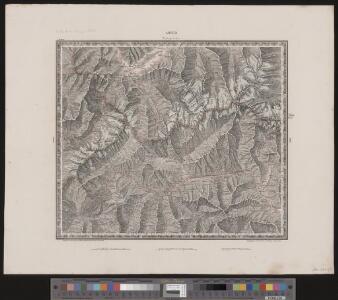
Aosta
1 : 200000 Herder, Bartholomew
Karte der Thäler von Bagne, Nendaz u. Hérémence im Wallis
1 : 300000 1 Karte G. St. Topogr. Anstalt v. J. Wurster u. Comp., [Winterthur]
[Malerisches Relief der Schweizer- und angränzenden Alpen]
1 : 135000 11 Vogelschaukarten Nach der Natur aufgenommen und gezeichnet von F.W. Delkeskamp ; gestochen v. Knopfmacher u. J.Ph. Dauch [Friedrich Wilhelm Delkeskamp], [Frankfurt am Main]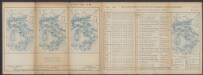
Valesiae Altera et VII. Nova Tabula. [Karte], in: Claud. Ptolemaeus. Geographia lat. cum mappis [...], S. 356.
1 Karte aus Atlas Münster, Sebastian [und Ptolemaeus, Claudius]
Martigny, Aoste
1 : 100000 1 Karte geologische Aufnahme von H. Gerlach [Wurster & Randegger], [Winterthur]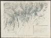
Partie du c.ton du Vallais et le versant des eaux du Piemont
1 : 108000 Weiss, Johann Heinrich ; Guérin, Christophe ; Meyer, Johann Rudolf J. R. Meyer
Carte du païs de Vallais, ou Wallisser-land
1 Karte : Kupferdruck ; 35 x 44 cm Valck; Schenk; Duval apud G. Valk et P. Schenk
Topographische Karte der Schweiz
1 : 100000 25 Karten vermessen und hrsg. auf Befehl der Eidgenössischen Behörden ; aufgenommen unter der Aufsicht des Generals G.H. Dufour Eidg. Topographisches Bureau, [Genève], [später: Bern]
Karte über einen Theil der südlichen Wallisthäler
1 : 100000 1 Karte frei gezeichnet nach topogr. Skitzen ... von G. Studer 1849 Heinrich Fuessli u. Comp. zur Meisen, Zürich
Carte géologique des parties de la Savoie, du Piémont et de la Suisse voisines du Mont Blanc
1 : 150000 Favre, Alphonse Etablissement topographique de J. Wurster et Cie.
Vallesia Superior, ac Inferior Wallis le Valais, geographice repraesentata
1 : 200000 Mollova mapová sbírka Walser, Gabriel Homann, Johann Baptista - dědici
Carte du Pais de Vallais ou Wallis Ser-Land
1 : 250000 Mollova mapová sbírka Duval, Pierre Schenk, Peter I
Rhodani progressus per Vallesiam
1 : 100000 1 Karte juxta observationes proprias factas in Itinere Alpino a Joanne Jacobo Scheuchzero sumptibus Petri vander Aa, Lugd. Bat. [i.e. Leiden]
Rhodani progressus per Vallesiam
1 : 100000 1 Karte a Joanne Jacobo Scheuchzero sumptibus Petri vander Aa, Lugd. Bat. [i.e. Leiden]

Wandkarte der Schweiz
1 : 200000 1 Karte auf 8 Blättern J.M. Ziegler Wurster, Winterthur
Original von Keller's zweiter Reisekarte der Schweiz
1 : 500000 1 Karte in 4 Teilen gest. v. J. Scheurmann Keller, Zürich
Atlas Suisse
1 : 120000 16 Karten levé et dessiné par J.H. Weiss [et Joachim Eugen Müller] aux frais de J.R. Meyer à Aarau dans les années 1786 à 1802 ; gravée [sic] par [Christophe] Guérin, [Matthias Gottfried] Eichler et [Johann Jakob] Scheurmann [Johann Rudolf Meyer], Aarau
Blatt XXII: Martigny, Aoste, uit: Topographische Karte der Schweiz / vermessen und hrsg. ... unter Aufsicht des Generals G.H. Dufour
1 : 100000 Annotatie: Met plaatsnamenregister (bl. V), bladwijzer (bl. XXI) en hoogteregister (bl. XXV); Voor aanwezige bladen zie overzichtsblad Dufour, G. H. [Bern : Eidg. Topogr. Bureau]