Maps of Graubünden
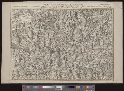
Carte topographique d'Allemagne contenant une partie de la Suisse savoir les cantons de Luzern, Schwitz, Zug, Clarus, Unterwalden, Bern et le comté de Sargan
1 Karte fait par I. W. Iaeger chez l'auteur, Francfort sur le Mein
Argow cum parte merid. Zurichgow [Karte], in: Le théâtre du monde, ou, Nouvel atlas contenant les chartes et descriptions de tous les païs de la terre, Bd. 1, S. 285.
1 Karte aus Atlas Blaeu, Willem Janszoon und Blaeu, Joan Blaeu, Willem Janszoon
Die Eisgebyrge des Schweizerlandes, mit allen dabey vorkommenden Mineralien
1 Karte auf 2 Blatt : Kupferdruck ; 39 x 81 cm Gruner; Zingg s.n.
[Luzern, Zug, Uri, Schwyz, Unterwalden, Glarus, Teile Aargau und Zürich] [Karte], in: Gerardi Mercatoris Atlas, sive, Cosmographicae meditationes de fabrica mundi et fabricati figura, S. 270.
1 Karte aus Atlas Mercator, Gerhard Montanus, Petrus
Argow cum parte merid. Zurichgow [Karte], in: Theatrum orbis terrarum, sive, Atlas novus, Bd. 1, S. 297.
1 Karte aus Atlas Blaeu, Joan Blaeu, Willem Janszoon
Argow cum parte merid. Zurichgow [Karte], in: Novus atlas absolutissimus, Bd. 4, S. 245.
1 Karte aus Atlas Janssonius Offizin
Argow cum parte merid. Zvrichgow
1 Karte : Kupferdruck ; 37 x 48 cm Mercator; Janssonius Joannes Janssonius
Argow cum parte merid. Zvrichgow
1 Karte : Kupferdruck ; 37 x 48 cm Mercator; Schenk; Valck apud G. Valk et P. Schenk
Argow cum parte merid. Zvrichgow
1 Karte : Kupferdruck ; 37 x 49 cm Blaeu; Mercator Willem Janszoon Blaeu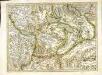
[Argow]
1 Karte : Kupferdruck ; 34 x 45 cm Mercator; Hondius Henricus Hondius
[Argow]
1 Karte : Kupferdruck ; 34 x 45 cm Mercator s.n.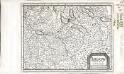
Argow
1 Karte : Kupferdruck ; 14 x 18 cm s.n.
[Argow] [Karte], in: Gerardi Mercatoris et I. Hondii Newer Atlas, oder, Grosses Weltbuch, Bd. 1, S. 265.
1 Karte aus Atlas Mercator, Gerhard und Hondius, Jodocus Jansson, Jan
Argow cum parte merid. Zvrichgow
1 : 310000 Mollova mapová sbírka Mercator, Gerhard Schenk, Peter I
Argow cum parte merid. Zvrichgow
1 : 320000 Mollova mapová sbírka Mercator, Gerhard Blaeu, Joan I.
Argow
1 : 243000 Aargau (Švýcarsko : kanton) Mercator, Gerhard G. Mercator
Argow cum parte merid. Zurichgow [Karte], in: Novus Atlas, das ist, Weltbeschreibung, Bd. 1, S. 254.
1 Karte aus Atlas Blaeu, Joan Blaeu, Willem Janszoon
ARGOW | cum parte merid. | ZVRICHGOW
Auctore Ger. Mercatore. [Amsterdam : Joan Blaeu]

[Exactissima Helvetiae, Rhaetiae, Valesiae ... tabula]
1 : 850000 9 Karten [Kopie von Adrian Braakman] [chez Pierre Schenk et Adrian Braakman], [Amsterdam]
Reliefkarte der Centralschweiz
1 Vogelschaukarte construirt und gezeichnet von X. Imfeld ; hrsg. vom Verein zur Förderung des Fremdenverkehrs am Vierwaldstättersee und Umgebung Wurster, Zürich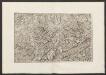
Militair Karte von Süd-Deutschland in 20 Sectionen
1 : 400000 17. Section Coulon, Alois von A. von Coulon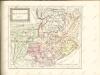

Zürich
1 : 200000 1 Karte entworfen und bearbeitet von Woerl ; in Stein gestochen unter seiner Leitung 1834 ; Lithographie von B. Herder Herder, Freiburg im Breisgau
Landtaflen
1 Atlas [von Johannes Stumpf] Christoffel Froschower, Zürych
Passage des alpes
1 : 100000 1 Karte dressé d'après les instructions de J. Michel par L. Pestalozzi : plan général Wurster, Winterthur
Kantone Uri, Schwyz und Unterwalden
1 : 1450000 [Stumme Kartenskizzen der ganzen Schweiz und der einzelnen Kantone zu Unterrichtszwecken] Schulbuchhandlung Antenen
Le Theatre de Bellone :
Mollova mapová sbírka Schenk, Pieter Braakman, Adriaan
Atlas novus Reipublicae Helveticae
1 Atlas ([40] Bl., 97 S.) bey Orell, Gessner und Compagnie, Zürich