Maps of Valais/Wallis

Distanzenkarte von der Schweiz
1 : 200000 1 Karte in 8 Teilen nach den besten Hülfsquellen bearb. von R. Huber Wagner, Bern
Carte de la Suisse avec les plans des cheflieux des 22 cantons
1 : 200000 1 Karte auf 8 Bl. dessinée et publié par Henri Keller ; Lithogr. von J. Schweizer = Charte der Schweiz mit den Grundrissen der Hauptorte der 22 Cantone Keller, Zürich
Taschen-Atlas der Schweiz
1 Atlas (25 S., 20 Taf.) gezeichnet und gestochen von Emil Wagner = Atlas de poche de la Suisse : 26 cartes en couleurs / dessinées et gravées par Émile Wagner Eggimann, Genf
Atlas der Schweiz
1 : 450000 1 Atlas (18 Bl.) gez. u. gest. v. J. Scheurmann Orell Fussli, Zurich
<<Der>> Canton Wallis
1 : 450000 1 Karte gez. u. gest. v. J. Scheuermann Orell Füssli & Comp., Zürich
<<Der>> Canton Wallis
1 : 450000 1 Karte gez. u. gest. v. J. Scheuermann Orell Füssli & Comp., Zürich
<<Der>> Canton Wallis
1 : 450000 1 Karte gez. u. gest. v. J. Scheuermann Orell Füssli & Comp., Zürich
[Wallis]
1 : 500000 1 Karte [Johannes Stumpf] [Christoffel Froschouer], [Zürych]
<<Der>> Canton Wallis
1 : 450000 1 Karte gez. u. gest. v. J. Scheuermann Orell Füssli & Comp., Zürich
Wandkarte der Schweiz
1 : 200000 1 Karte auf 8 Blättern J.M. Ziegler Wurster, Winterthur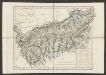
Canton Wallis
1 : 450000 Scheuermann, Johann Jakob Orell Füssli & Comp.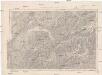
Generalkarte der Schweiz
1 : 250000 Švýcarsko Müllhaupt, H. Eidg. Landestopographie
<<Der>> Canton Wallis
1 : 450000 1 Karte gez. u. gest. v. J. Scheuermann Orell Füssli & Comp., Zürich
Les Estats de Savoye et de Piémont le Dauphiné, la Bresse Partie du Lionnois et de la Provence.
1 : 250000 Mollova mapová sbírka Jaillot, Alexis-Hubert Jaillot, Alexis Hubert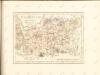

Valais
1 : 1450000 [Stumme Kartenskizzen der ganzen Schweiz und der einzelnen Kantone zu Unterrichtszwecken] Schulbuchhandlung Antenen
Atlas de la Suisse
1 : 450000 1 Atlas (19 Bl.) dessiné par MM. H. Keller, Scheurmann, Pfyffer d'Altishofen, Osterwald, etc. ; gravé par M. Scheurmann Orell Füssli & Co., Zürich
<<Der>> Canton Bern
1 : 390000 1 Karte gez. u. gest. v. J.J. Scheuermann Orell Füssli & Comp., Zuric [i.e. Zürich]
Eisgebyrge des Schweizerlandes mit allen dabey vorkommenden Mineralien
Blatt Westteil Gruner, Gottlieb Sigmund ; Zingg, Adrian [Abraham Wagner, Sohn]
<<Der>> Canton Bern
1 : 390000 1 Karte gez. u. gest. v. J.J. Scheuermann Orell Füssli & Comp., Zuric [i.e. Zürich]
Vallesia Superior, ac Inferior Wallis le Valais, geographice repraesentata
1 : 200000 Mollova mapová sbírka Walser, Gabriel Homann, Johann Baptista - dědici
Carte du Pais de Vallais ou Wallis Ser-Land
1 : 250000 Mollova mapová sbírka Duval, Pierre Schenk, Peter I
Atlas der Schweiz
1 : 450000 1 Atlas (18 Bl.) gez. u. gest. v. J. Scheurmann Orell Fussli, Zurich
Carte du Païs De Vallais, ou Wallisser-Land [Karte], in: Novus atlas absolutissimus, Bd. 4, S. 248.
1 Karte aus Atlas Janssonius Offizin
<<Der>> Canton Bern
1 : 390000 1 Karte gez. u. gest. v. J.J. Scheuermann Orell Füssli, Zuric [i.e. Zürich]
Carte d'une partie des cantons de Berne de Fribourg du païs de Veau et du Valais &c
1 Blatt : Covens et Mortier
Nova Helvetiae tabula geographica, 3
1 Blatt : Pieter Schenk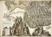
Nova Helvetiae tabula geographica, 3
1 Blatt : Johann Jakob Scheuchzer
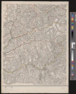
Schulwandkarte zur Geschichte der Schweiz
1 : 180000 Südblatt Oechsli, Wilhelm ; Baldamus, Alfred Kartograph. Verlagsanstalt von Georg Lang