Maps of Switzerland

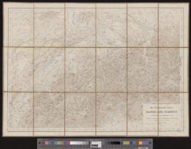
Oro-hydrographische Karte der Schweiz
1 : 500000 1 Karte gest. v. Leuzinger u. v. Hoven Eidg. Stabsbureau, [Bern]
Geologische Karte der Schweiz
1 : 500000 1 Karte auf Grundlage der "Beiträge zur geolog. Karte der Schweiz" und der neuesten Materialien, sowie unter Mitwirkung der Herren Renevier ... [et al.] bearb. im Auftrage der Schweizerischen Geologischen Commission von Alb. Heim & C. Schmidt ; topogr. Grundlage von R. Leuzinger ; hrsg. von der Schweiz. Geologischen Commission Schlumpf, Winterthur
Geologische Karte der Schweiz |p [stumme Karte]
1 : 500000 Heim, Albert Topogr. Anstalt Winterthur. J. Schlumpf
Relief-Karte der Schweiz
1 : 530000 Leuzinger, Rudolf J. Wurster & Co.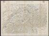
Officielle Eisenbahnkarte der Schweiz
1 : 500000 Schweiz Eidgenössisches Post- und Eisenbahndepartement. Kümmerly & Frey
Geologische Karte der Schweiz |p [Abzug der schwarzen Druckplatte]
1 : 500000 Heim, Albert [Topogr. Anstalt Winterthur. J. Schlumpf]
[Recto], uit: Reiskaart van Zwitserland / kartografie: Kümmerly & Frey
1 : 600000 titelvariant: Kaart van Zwitserland; Annotatie: Omslagtitel: Kaart van Zwitserland Kümmerly + Frey, Bern Zürich [etc.] : Zwitsersche Verkeerscentrale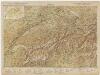
[Kaart], uit: Carte scolaire de la Suisse = Schulkarte der Schweiz / H. Kümmerly
1 : 600000 titelvariant: Schulkarte der Schwei; Annotatie: Op omslag (verso): statische gegevens; Annotatie geografische gegevens: Inzet: Politische Übersicht = Carte politique = Carta politica. - Schaal 1:2.750.000 H. Kümmerly Bern : Kümmerly & Frey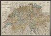
Karte der Schweiz für Schulen
1 : 750000 Leuzinger, Rudolf Benziger & Co. A.G.
Die Schweiz auch Fürstenthum Liechtenstein
Schul-Atlas über alle Theile der Erde nach dem neuesten Zustande, und über das Weltgebäude Stieler, Adolf bei Justus Perthes
Carte de la Suisse
1 : 1000000 1 Karte Kümmerly & Frey, Bern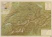
Suisse

Karte der Schweiz
1 : 400000 1 Karte von R. Leuzinger ; Schrift von Ch. v. Hoven = Carte de la Suisse / par. R. Leuzinger Chez J. Dalp (Ch. Schmid), Berne
Nouvelle carte itinéraire
1 : 700000 Švýcarsko Weiss, H. Bourgdorfer, J. J. J.J. Bourgdorfer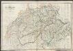
Switzerland
A new general atlas of modern geography, consisting of a complete collection of maps of the four quarters of the globe Wyld, James James Wyld
Carte de la Suisse pour les écoles
1 : 700000 1 Karte R. Leuzinger Verlag der J. Dalp'schen Buch & Kunsthandlung (Carl Schmid), Bern
Karte der Schweiz
1 : 400000 1 Karte von R. Leuzinger ; Schrift von Ch. v. Hoven chez J. Dalp (C. Schmid), Berne
Switzerland.
1 : 1310000 Finley, Anthony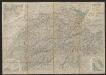
Roadmap of Switzerland
1 : 355000 Müllhaupt, Hans Heinrich ; Bressanini, Rinaldo ; Leuthold, Hans Felix Leuthold
Karte der Posten, Telegraphen und Eisenbahnen der Schweizerischen Eidgenossenschaft
1 : 300000 Jent & Gassmann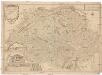
Les Suisses leurs sujets et leurs alliez
1 : 500000 Švýcarsko Fer, Nicolas de Dant Dant
Switzerland.
1 : 1480000 Arrowsmith, Aaron; Lewis, Samuel
Switzerland.
1 : 1480000 Arrowsmith, Aaron; Lewis, Samuel
Carte de Suisse
1 Karte dressé sur les memoires de Merveilleux par Guillaume de l'Isle chez l'auteur sur le Quay de l'Horloge, Paris
Karte der Fundorte von Rohproducten in der Schweiz
1 : 520000 1 Karte von Julius Weber und A. Brosi ; veröffentlicht auf Veranlassung des Schweizerischen Handels u. Landwirthschafts-Departements ; [Kartogr.:] Topogr. Anstalt v. Wurster, Randegger & Co. J. Wurster & Cie., Zürich
La Suisse
1 Karte : Kupferdruck ; 46 x 63 cm Bonne; Lattré chés Lattré grav.r ord. de Mons.gr le Dauphin ruë S. Jacques à la ville de Bordeaux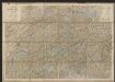
Karte der Schweiz
1 : 400000 Leuzinger, Rudolf J. Dalp (C. Schmid)
Atlas für die Heimathskunde der Schweiz
1 : 19000000 1 Atlas (12, 12 Bl.) von J.S. Gerster ; gestochen von R. Leuzinger Dalp, Bern
Schweiz
Volksschul-Atlas über alle Teile der Erde Lange, Henry Druck und Verlag von Georg Westermann