Maps of Valais/Wallis

[Keller's Reisekarte der Schweiz]
1 : 500000 1 Karte auf 6 Bl. gezeichnet v. H. Keller ; gest. v. J.J. Scheurmann [Keller], Zürich
Reisekarte der Schweiz
1 : 500000 1 Atlas (1, 6 Bl.) gezeichnet von H. Keller und gestochen von J. Scheurmann = Carte routière de la Suisse / dessinée par H. Keller et gravée par J. Scheurmann bey Fuessli und Comp., Zürich
Schulwandkarte zur Geschichte der Schweiz
1 : 180000 1 Karte auf 6 Bl. bearbeitet v. W. Oechsli u. A. Baldamus ; gezeichnet von Ed. Gaebler Kartograph. Verlagsanstalt von Georg Lang, Leipzig
Atlas der alten Eidgenossenschaft in 20 Karten: Oberwallis und Unterwallis
Originaltitel: Vallesia superior ac inferior, Wallis. Mit Erklärung der Zeichen und Zeichnungen des Furkagletschers, des Gemmibergs, des Pissevache-Wasserfalls und des grossen St. Bernhards. Zeichnung: Walser, Gabriel (1695-1776), reformierter Pfarrer, von Teufen AR Herausgeber: Homännische Erben
Schulwandkarte zur Geschichte der Schweiz
1 : 180000 Südblatt Oechsli, Wilhelm ; Baldamus, Alfred Kartograph. Verlagsanstalt von Georg Lang
Raetiae veteris et exterae pars occidentalis qua Lepontii (gens perantiqua Cis ac Transalpina) continentur
1 : 550000 1 Karte [Matthias Hirtzgartner] [Joh. Rodolff Wolffen], [Zürich]
<<Die>> Lepontier
1 : 470000 1 Karte [Johannes Stumpf] [Froschauer], [Zürich]
Geologische Kartenskizze der Alpen zwischen St. Gotthard & Montblanc
1 : 350000 Alpy (pohoří) Schmidt, Carl Ernst Finckh
Nova Rhaetiae atque totius Helvetiae descriptio
1 : 350000 1 Karte auf 10 Bl. per Aegidium Tschudum Glaronensem Hofer & Burger, Zürich
Atlas der Schweiz
1 : 450000 1 Atlas (18 Bl.) gez. u. gest. v. J. Scheurmann Orell Fussli, Zurich
Locarno
1 : 200000 1 Karte entworfen und bearbeitet von Woerl ; in Stein gestochen unter seiner Leitung 1835 ; Lithographie von B. Herder Herder, Freiburg im Breisgau
Atlas de la Suisse
1 : 450000 1 Atlas (19 Bl.) dessiné par MM. H. Keller, Scheurmann, Pfyffer d'Altishofen, Osterwald, etc. ; gravé par M. Scheurmann Orell Füssli & Co., Zürich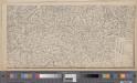
Original von Keller's zweiter Reisekarte der Schweiz
1 : 500000 1 Karte in 4 Teilen gest. v. J. Scheurmann Keller, Zürich
Atlas novus Reipublicae Helveticae
1 Atlas ([40] Bl., 97 S.) bey Orell, Gessner und Compagnie, Zürich
Carta della repubblica e cantone del Ticino e de suoi contorni Lombardi
1 : 400000 1 Karte par E.H. Michaelis ; écrit par R. Bressanini ; gravé par H. Müllhaupt chez Henri Fuessli et C., Zurich
Biella
1 : 200000 1 Karte entworfen und bearbeitet von Woerl ; in Stein gestochen unter seiner Leitung 1835 ; Lithographie von B. Herder Herder, Freiburg im Breisgau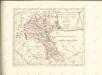

Landtaflen
1 Atlas [von Johannes Stumpf] Christoffel Froschower, Zürych
<<Der>> Canton Ticino
1 : 350000 1 Karte gezeichnet v. H. Keller nach Paolo Ghiringelli ; gest. von J.J. Scheurmann [Orell Füssli & Comp.], [Zürich]
Parte Alpestre Dello Stato Di Milano, Con il Lago Maggiore Di Lugano, É Di Como [Karte], in: Le théâtre du monde, ou, Nouvel atlas contenant les chartes et descriptions de tous les païs de la terre, Bd. 3, S. 63.
1 Karte aus Atlas Blaeu, Willem Janszoon und Blaeu, Joan Blaeu, Willem Janszoon
Atlas der Schweiz
1 : 450000 1 Atlas (18 Bl.) gez. u. gest. v. J. Scheurmann Orell Fussli, Zurich
Viaggio della Francia in Italia
1 : 1230000 Milán (Itálie)
Parte Alpestre Dello Stato Di Milano, Con il Lago Maggiore Di Lugano, È Di Como [Karte], in: Novus Atlas, das ist, Weltbeschreibung, Bd. 3, S. 73.
1 Karte aus Atlas Blaeu, Joan Blaeu, Willem Janszoon
Parte Alpestre Dello Stato Di Milano, Con il Lago Maggiore Di Lugano, É Di Como [Karte], in: Theatrum orbis terrarum, sive, Atlas novus, Bd. 3, S. 61.
1 Karte aus Atlas Blaeu, Joan Blaeu, Willem Janszoon
Parte Alpestre Dello Stato Di Milano Con il Lago Maggiore Di Lugano, È Di Como [Karte], in: Novus atlas absolutissimus, Bd. 5, S. 71.
1 Karte aus Atlas Janssonius Offizin
<<Der>> Canton Wallis
1 : 450000 1 Karte gez. u. gest. v. J. Scheuermann Orell Füssli & Comp., Zürich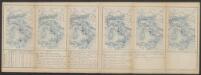
Valesiae Prior Et VI. Nova Tabula. [Karte], in: Claud. Ptolemaeus. Geographia lat. cum mappis [...], S. 353.
1 Karte aus Atlas Münster, Sebastian [und Ptolemaeus, Claudius]
Carte de la Suisse avec les plans des cheflieux des 22 cantons
1 : 200000 1 Karte auf 8 Bl. dessinée et publié par Henri Keller ; Lithogr. von J. Schweizer = Charte der Schweiz mit den Grundrissen der Hauptorte der 22 Cantone Keller, Zürich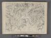
Majeure partie des Cantons de Bellinzona et de Lugano et les frontieres de la Republique Italienne.
From Atlas Suisse. Levé et dessiné par J. H. Weiss aux fraix de J. R. Meyer á Aarau dans les années 1786 á 1802. Gravée par Guerin, Eichler, et Scheurmann.
![[Keller's Reisekarte der Schweiz]](https://images-2.georeferencer.com/images/iiif/796443339020/full/,300/0/native.jpg)

