Maps of Switzerland

Taschen-Atlas der Schweiz
1 Atlas (25 S., 20 Taf.) gezeichnet und gestochen von Emil Wagner = Atlas de poche de la Suisse : 26 cartes en couleurs / dessinées et gravées par Émile Wagner Eggimann, Genf
Helvetiae seu Suiciae quae multis confoederatorum terra dicitur, primae Germanorum provinciae, Galliae, Italiaequae contiguae chorographia vera et elegans
1 Karte autore [Gerard de Jode] ; Ioannes à Deutecum, Lucas à Deutecum fecerunt [Gerard de Jode], [Antwerpen]
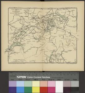
Verbreitungsweise der Alpen-Fündlinge
1 : 1200000 1 Karte Topogr. Anst. v. J. Wurster u. Comp. [Kiesling], [Zürich]
Helvetiae descriptio
1 : 900000 1 Karte Aegidio Tschudo auct. ; [Abraham Ortelius fecit] [apud Aegid. Coppenium Diesth], [Antverpiae]
Atlas für die Heimathskunde der Schweiz
1 : 19000000 1 Atlas (12, 12 Bl.) von J.S. Gerster ; gestochen von R. Leuzinger Dalp, Bern
Atlas für die Heimathskunde der Schweiz
1 : 19000000 1 Atlas (12, 12 Bl.) von J.S. Gerster ; gestochen von R. Leuzinger Dalp, Bern
Atlas für die Heimathskunde der Schweiz
1 : 19000000 1 Atlas (12, 12 Bl.) von J.S. Gerster ; gestochen von R. Leuzinger Dalp, Bern
Helvetiae Descriptio [Karte], in: Theatrum orbis terrarum, S. 277.
1 Karte aus Atlas Ortelius, Abraham Vrients, Jan Baptista
General-Carte der Schweiz
1 : 1200000 1 Karte entworfen und gestochen von J. Scheurmann bey Orell Füssli & Compagnie, Zürich
Atlas für die Heimathskunde der Schweiz
1 : 19000000 1 Atlas (12, 12 Bl.) von J.S. Gerster ; gestochen von R. Leuzinger Dalp, Bern
Atlas für die Heimathskunde der Schweiz
1 : 19000000 1 Atlas (12, 12 Bl.) von J.S. Gerster ; gestochen von R. Leuzinger Dalp, Bern
Atlas für die Heimathskunde der Schweiz
1 : 19000000 1 Atlas (12, 12 Bl.) von J.S. Gerster ; gestochen von R. Leuzinger Dalp, Bern
Atlas für die Heimathskunde der Schweiz
1 : 19000000 1 Atlas (12, 12 Bl.) von J.S. Gerster ; gestochen von R. Leuzinger Dalp, Bern
Helvetiae Descriptio [Karte], in: Theatrum orbis terrarum, S. 182.
1 Karte aus Atlas Ortelius, Abraham
Uebersichts-Karte der Schweiz
1 : 1050000 1 Karte für den Schulgebrauch bearbeitet von Rudolph Gross ; gestochen von Rixinger u. Graf Ch. Beyel, Frauenfeld
Helvetiae Descriptio [Karte], in: Theatrum orbis terrarum, S. 77.
1 Karte aus Atlas Ortelius, Abraham
Atlas für die Heimathskunde der Schweiz
1 : 19000000 1 Atlas (12, 12 Bl.) von J.S. Gerster ; gestochen von R. Leuzinger Dalp, Bern
<<Die>> Schweiz mit den projectirten Eisenbahnen und Telegraphen
1 : 1200000 1 Karte Topogr. Anstalt von Joh. Wurster u. Comp., Winterthur
Helvetia
1 : 1900000 1 Karte [Zacharias Heyns] [pour Zacharie Heyns, à l'Enseigne des trois vertus], [Amsterdam]
Karte der Schweiz mit Rücksicht auf die Post-Strassen
1 : 1350000 1 Karte nach Hrch. Keller ; Lith. von J. Kull bei J.H. Locher, Zürich
Guide topographique des chemins de fer Suisses
1 Atlas (48 Bl.) Wurster, Winterthur
Helvetische Republik eingetheilt in Cantone und Districte
1 : 1300000 1 Karte [Johann Jakob Scheurmann] [Orell Füssli & Co.], [Zürich]
<<Die>> Schweiz 1849
1 : 1520000 1 Karte entworf. u. gezeichnet v. [C.Ch.F.] Radefeld Bibliograph. Institut, Hildburghausen
Suisse
1 : 2500000 1 Karte by Rt. Morden [printed for Robert Morden and Thomas Cockerill?], [London]
Helvetiae seu Suiciae quae multis confoederatorum terra dicitur, primae Germanorum provinciae, Galliae, Italiaequae contiguae chorographia vera et elegans
1 Karte autore [Gerard de Jode] ; Ioannes à Deutecum, Lucas à Deutecum fecerunt [Gerard de Jode], [Antwerpen]
Karte der Schweiz für den ersten geographischen Unterricht
1 : 1600000 1 Karte [von David Bürkli?] bey D. Bürkli, Zürich
Helvetiae seu Suiciae quae multis confoederatorum terra dicitur, primae Germanorum provinciae, Galliae, Italiaequae contiguae chorographia vera et elegans
1 Karte autore [Gerard de Jode] ; Ioannes à Deutecum, Lucas à Deutecum fecerunt [Gerard de Jode], [Antwerpen]
[Helvetia]
1 : 700000 1 Karte auf 2 Bl. Paulus de Forlanis [Forlani], Venetij
[Chemins de fer en Suisse]
1 : 1200000 1 Karte J. Wurster et Comp., Winterthur