Maps of Jura

Landtaflen
1 Atlas [von Johannes Stumpf] Christoffel Froschower, Zürych
Sabavdiae, et Bvrgvndiae comitatus descriptio
1 Karte : Kupferdruck ; 30 x 21 cm Ortelius; Boileau de Bouillon s.n.
Fragment de l'Atlas de la Suisse par Tschudi 1538
Tschudi, Aegidius Hofer & Burger
Illustrations of the Glacier Systems of the Alps and of Glacial Phenomena in general
The physical atlas Johnston, Alexander Keith William Blackwood & Sons
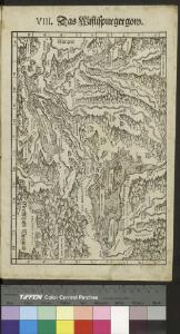
<<Das>> Wiflispurgergow
1 : 500000 1 Karte [von Johannes Stumpf] [Christoph Froschauer oder Johann Wolf], [Zürich]
Touristen-Karte der Schweiz
1 : 400000 Evropa Imfeld, X. Jura–Simplon-Bahn
Carte de la Suisse
1 : 400000 1 Karte auf 2 Blättern de R. Leuzinger = Karte der Schweiz : Gewässer & Gebirge / von R. Leuzinger Verlag der Dalp'schen Buchhandlung, Bern
Neue Karte von der Schweiz oder Helvetien in die XIII Eidgenossenschaften, ihre Bundsverwandten und Unterthanen eingetheilt
1 Karte in 2 Bl nach den zuverlässigsten Nachrichten und neuesten astronomischen Beobachtungen, London 1778 bei W. Faden [, neu hrsg. von F.A. Schraembl] Schalbacher, Wien
Carte du réseau télégraphique Suisse
1 : 250000 Westblatt Schweizerische Telegraphen- und Telephonverwaltung Kartographische Anstalt LIPS
Atlas novus Reipublicae Helveticae
1 Atlas ([40] Bl., 97 S.) bey Orell, Gessner und Compagnie, Zürich
Carte de Suisse suivant sa nouvelle division en XVIII cantons
1 Karte in 2 Bl. dressé par H. Mallet, Ing. Geographe [Verlag nicht ermittelbar], [Erscheinungsort nicht ermittelbar]
<<Les>> Suisses, leurs alliés et leurs sujets
1 : 230000 1 Karte auf 4 Bl. par A.H. Iaillot, 1703 chez l'auteur joignant les grands Augustins aux deux globes, Paris
<<Das>> Wiflispurgergow
1 : 500000 1 Karte [von Johannes Stumpf] [Christoph Froschauer oder Johann Wolf], [Zürich]
<<Les>> Suisses, leurs alliés et leurs sujets
1 : 230000 1 Karte auf 4 Bl. par Iaillot chez l'auteur joignant les Grands Augustins aux deux Globes, Paris
Carte du réseau téléphonique suisse
1 : 250000 Westblatt Schweizerische Telegraphen- und Telephonverwaltung H. & A. Kümmerly & Frey
Parte occidentale dell'Elvezia divisa ne' suoi cantoni
1 : 600000 1 Karte di nuova projezione / [G. Zuliani inc.] ; [G. Pitteri scri.] presso Antonio Zatta, Venezia
Nouvelle carte géographique de la Suisse
1 : 600000 1 Karte auf 4 Bl. dressé par Jacq. Scheuchzer chez R. & J. Wetstein et Guil. Smith, Amsterdam
Karte des Kriegs-Schauplatzes der Schweiz
1 : 700000 2 Karten Verlag der Steiner'schen Buchhandlung, [Winterthur]
Neue Schweizerkarte von 1847
1 : 300000 1 Karte auf 4 Bl. als Wand- und Reliefkarte topisch und politisch dargestellt von Eduard Winckelmann Tobias Dannheimer, Kempten
Nouvelle carte géographique de la Suisse
1 : 600000 1 Karte auf 4 Bl. dressé par Jacq. Scheuchzer chez R. & J. Wetstein et Guil. Smith, Amsterdam
Nova Helvetiae tabula geographica
1 : 1000000 Südwest-Blatt Scheuchzer, Johann Jakob ; Schenck, Peter ex officina Petri Schenckii
Atlas der alten Eidgenossenschaft in 20 Karten: Kanton Bern
Originaltitel: Canton Bern sive Illustris Helvetiorum Respublica Bernensis cum Subditis suis et Confinibus. Zeichnung: Walser, Gabriel (1695-1776), reformierter Pfarrer, von Teufen AR Herausgeber: Homännische Erben
Burgundiae Comitatus, Franche Comté. [Karte], in: Gerardi Mercatoris et I. Hondii Newer Atlas, oder, Grosses Weltbuch, Bd. 2, S. 95.
1 Karte aus Atlas Mercator, Gerhard und Hondius, Jodocus Jansson, Jan
Mappa Geographica illustris Helvetiorum Republicae Bernensis cum adjacentibus pagorum et dynastiarum confiniis accurate delineata
1 : 460000 Mollova mapová sbírka Seutter, Matthäus Seutter, Albrecht Carl Seutter, Matthäus
Mappa Geographica illustris Helvetiorum Republicae Bernensis cum adjacentibus pagorum et dynastiarum confiniis accurate delineata
1 : 460000 Mollova mapová sbírka Seutter, Matthäus Seutter, Albrecht Carl Seutter, Matthäus
[Burgund] [Karte], in: Gerardi Mercatoris Atlas, sive, Cosmographicae meditationes de fabrica mundi et fabricati figura, S. 258.
1 Karte aus Atlas Mercator, Gerhard Montanus, Petrus
Comitatus sive Liberae Burgundiae nova tabula, vulgo dicta la Franche Comté, divitur tam in praefecturas tres generales, quam in plurimas subalternas
1 : 390000 per F. de Witt Amstelodami : [Frederick de Wit]
Officielle Eisenbahn-Karte der Schweiz
1 : 250000 Südwest-Blatt [s.n.]