Maps of Bern

Landtaflen
1 Atlas [von Johannes Stumpf] Christoffel Froschower, Zürych
Carte des Kantons Bern
1 : 400000 1 Karte Topogr. Anstalt von Wurster, Randegger & Co in Winterthur Schulbuchhandlung Antenen (W.Kaiser), Bern
<<Die>> Kantone Bern und Solothurn
1 : 450000 1 Karte gez. von Rud. Gross Ch. Beyel, Zürich
Carte des Kantons Bern
1 : 400000 1 Karte Topogr. Anstalt von Wurster, Randegger & Co in Winterthur Schulbuchhandlung Antenen, Bern
Karte des Cantons Bern
1 : 200000 Kutter, Wilhelm Rudolf ; Leuzinger, Rudolf J. Dalp'sche Buch- und Kunsthandlung (Karl Schmid)
Per Inclyti Circuli Suevici Supremorum Ordinum :
1 : 160000 Mollova mapová sbírka Pfeffel, Johann Andreas Pfeffel, Johann Andreas I.
Charte des Kanton Bern
1 : 1546000 Bern (Švýcarsko : kanton) Schlieben Gleditsch
Per Inclyti Circuli Suevici Supremorum Ordinum :
1 : 160000 Mollova mapová sbírka Pfeffel, Johann Andreas Homann, Johann Baptista - dědici
Carte archéologique du Canton de Berne
1 : 200000 Bonstetten, Gustav Karl <
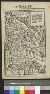
Argow cum parte merid. Zurichgow [Karte], in: Novus atlas absolutissimus, Bd. 4, S. 245.
1 Karte aus Atlas Janssonius Offizin
Carte des Cantons Bern
1 : 190000 Durheim, Karl C. Durheim
<<Der>> Canton Bern
1 : 390000 1 Karte gez. u. gest. v. J. Scheuermann Orell Füssli & Comp., Züric [i.e. Zürich]
Kanton Bern
1 : 1450000 [Stumme Kartenskizzen der ganzen Schweiz und der einzelnen Kantone zu Unterrichtszwecken] Schulbuchhandlung Antenen
Argow cum parte merid. Zurichgow [Karte], in: Novus Atlas, das ist, Weltbeschreibung, Bd. 1, S. 254.
1 Karte aus Atlas Blaeu, Joan Blaeu, Willem Janszoon
[Argow] [Karte], in: Gerardi Mercatoris et I. Hondii Newer Atlas, oder, Grosses Weltbuch, Bd. 1, S. 265.
1 Karte aus Atlas Mercator, Gerhard und Hondius, Jodocus Jansson, Jan
Argow cum parte merid. Zurichgow [Karte], in: Theatrum orbis terrarum, sive, Atlas novus, Bd. 1, S. 297.
1 Karte aus Atlas Blaeu, Joan Blaeu, Willem Janszoon
24) IX.N.E. ''Berne'', uit: Carte géologique de France
1 : 500000 Annotatie: Voor aanwezige bladen zie bladoverzicht [S.l : s.n.]
<<Der>> Canton Bern
1 : 390000 1 Karte gez. u. gest. v. J. Scheuermann Orell Füssli & Comp., Züric [i.e. Zürich]
[Luzern, Zug, Uri, Schwyz, Unterwalden, Glarus, Teile Aargau und Zürich] [Karte], in: Gerardi Mercatoris Atlas, sive, Cosmographicae meditationes de fabrica mundi et fabricati figura, S. 270.
1 Karte aus Atlas Mercator, Gerhard Montanus, Petrus

ARGOW | cum parte merid. | ZVRICHGOW
Auctore Ger. Mercatore. [Amsterdam : Joan Blaeu]
Zvrichgow et Basiliensis provincia
1 Karte : Kupferdruck ; 37 x 48 cm Janssonius; Broeck apud Johannem Janssonium
Zvrichgow et Basiliensis provincia
1 Karte : Kupferdruck ; 37 x 48 cm Valck; Schenk; Broeck apud G. Valk et P. Schenk
Zvrichgow et Basiliensis provincia
1 Karte : Kupferdruck ; 37 x 48 cm Blaeu Willem Janszoon Blaeu
Zvrichgow et Basiliensis provincia
1 Karte : Kupferdruck ; 36 x 48 cm Mercator; Blaeu s.n.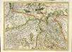
[Zurichgow, et Basiliensis provincia]
1 Karte : Kupferdruck ; 34 x 46 cm Mercator; Hondius Henricus Hondius
[Zurichgow, et Basiliensis provincia]
1 Karte : Kupferdruck ; 34 x 45 cm Mercator s.n.
Argow cum parte merid. Zurichgow [Karte], in: Le théâtre du monde, ou, Nouvel atlas contenant les chartes et descriptions de tous les païs de la terre, Bd. 1, S. 285.
1 Karte aus Atlas Blaeu, Willem Janszoon und Blaeu, Joan Blaeu, Willem Janszoon
Tschudi's Touristenkarte der Centralschweiz
1 : 250000 1 Karte Stich u. Druck: Wurster, Randegger Scheitlin & Zollikofer, St. Gallen