Maps of Mediterranean Sea

Landtaflen
1 Atlas [von Johannes Stumpf] Christoffel Froschower, Zürych
Patriarchatus Romanus
1 : 11100000 Mollova mapová sbírka Sanson, Nicolas Covens, Johannes I
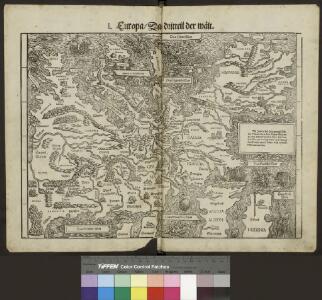
Europa im 16. Jahrhundert (1559)
1 : 15000000 Europa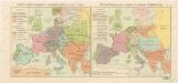
Rozsah panství Habsburků ... za Karla V. (1555) Říše Napoleonova (1810) a Evropa po kongresu Vídeňském (1815)

Europe Centrale en 1920
1 : 4200000 titelvariant: Nouvelle carte de l'Europe Centrale; Annotatie: Titel linksboven: Nouvelle carte de l'Europe Centrale Paris : Taride
Österreich-Ungarn und Bosnien-Hercegovina
Eberle, Joseph
Eisenbahn- Post- und Dampfschiffahrts-Karte von Europa
1 : 8000000 Evropa Denk, L. Lith. Anst. v. L. Mohn's Witwe
Roman Empire, Palestine.
1 : 15200000 Worcester, Joseph E.
Europa Prima Nova Tabula [Karte], in: Claud. Ptolemaeus. Geographia lat. cum mappis [...], S. 332.
1 Karte aus Atlas Münster, Sebastian [und Ptolemaeus, Claudius]
Europa 1993
Europa Kunz, Andreas ; Moeschl, Joachim Robert
20. Europa im 16. Jahrhundert (1559)
1 : 15000000 Europa
A map of the western part of the Roman empire
1 Karte : Kupferdruck ; 39 x 46 cm s.n.

Roman Empire, Greece.
1 : 17000000 Mitchell, Samuel Augustus
[Historisch-geographischer Atlas zu den allgemeinen Geschichtswerken von C. v. Rotteck, Pölitz u. Becker] : Die Völkerwanderung nach ihren Ausgangspunkten, Zügen und Niederlassungen
von Julius Loewenberg Lithographie von B. Herder in Freiburg im Breisgau [Freiburg im Breisgau] : [Herder]
Paasche's Frontenkarte, Nr. 11 Europäische Kriegsschauplätze

Europa 1772
Europa Kunz, Andreas ; Moeschl, Joachim Robert
Europa 1937
Europa Kunz, Andreas ; Moeschl, Joachim Robert
Europa 1721
Europa Kunz, Andreas ; Moeschl, Joachim Robert
Europa 1718
Europa Kunz, Andreas ; Moeschl, Joachim Robert
Europa 1648
Europa Kunz, Andreas ; Moeschl, Joachim Robert
Europa 1795
Europa Kunz, Andreas ; Moeschl, Joachim Robert
Europa 1748
Europa Kunz, Andreas ; Moeschl, Joachim Robert
Machtverhältnisse der Europ. Staaten
1 : 14000000 Zolltarife Block, Maurice Justus Perthes
Europa 2003
Europa Kunz, Andreas ; Moeschl, Joachim Robert
23. Europa im 17. und 18. Jahrhundert (1740)
1 : 15000000 Europa
Europa 1580
Europa Kunz, Andreas ; Moeschl, Joachim Robert
Europa 1793
Europa Kunz, Andreas ; Moeschl, Joachim Robert
Europa 1699
Europa Kunz, Andreas ; Moeschl, Joachim Robert