Maps of Sardegna

Maps of Sardegna

$title$

Carte Nouvelle de L'Isle Et Royaume De Sardagne. &c. Levée par Ordre Expres à L'Usage des Armées en Italie ou sont Exactement Marquées les Grands-Chemins. &c. [Karte], in: Atlas nouveau, contenant toutes les parties du monde [...], Bd. 2, S. 148.
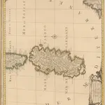
1 Karte aus Atlas Sanson, Nicolas Jaillot, Alexis Hubert und Mortier, Pieter
$title$

[34][34] Insularum Sardiniae et Corsicae descriptio, uit: Atlas sive Descriptio terrarum orbis

Annotatie: Gedigitaliseerde versie. Amsterdam. Heiloo : Picturae (vervaardiger), 2015. tiff-bestand. Gedigitaliseerd: 07-01-2015; Origineel: Universiteitsbibliotheek Vrije Universiteit (XL.05127.-) ; Netherlands; Titelpagina ontbreekt Wit, Frederik de Amsterdam : Frederick de Wit
$title$

De eijlanden van Corcica en Zardinia met de tegen overcust van Barbaria

France Gerard van Keulen
$title$

Die Königreiche Spanien und Portugal nach den neuesten Beobachtungen verfast

Španělsko Votésky, Michael Mollo, Tranquillo Tranquillo Mollo
$title$

Die Königreiche Spanien und Portugal nach den neuesten Beobachtungen verfasst

Španělsko Renner Kleinknecht T. Mollo
$title$

[Italien, Blatt 3]

Adolf Stieler's Handatlas über alle Theile der Erde und über das Weltgebäude Stieler, Adolf Justus Perthes
$title$

Karte von Spanien und Portugal.

Španělsko Brué, A. H. Rothenburg, R. v. Artaria
$title$

Carte De La Mer Mediterranee. V.

Roux, Joseph
$title$

Nouvelle carte politique, militaire et routiere de l'Espagne et du Portugal

Španělsko Tramezini, Michaelo Hinrichs, J. C. J.C. Hinrichs
$title$

Spanien und Portugal

Španělsko Weiland, Karl Ferdinand Jaeger, I. G. im Verlage des Geograph. Instituts
$title$

Hispaniae et Portugalliae regna

Španělsko Visscher, Nicolaus Almada, Andrea d' per Nicolaum Visscher
$title$

Totivs descriptio Hispaniae

Španělsko Renner Kleinknecht
$title$

Carta d'Italia alla scala di 1 a 1 000 000

1 : 1000000 Westblatt Istituto Geografico Militare (Firenze) Istituto Geografico Militare
$title$

Carta d'Italia alla scala di 1 a 1 000 000

1 : 1000000 Südwest-Blatt Istituto Geografico Militare (Firenze) Istituto Geografico Militare
$title$

[Itálie]

1 : 1150000 Achaia (Řecko)
$title$

Fo. 5, uit: Carta geologica d'Italia

1 : 1000000 Rome : R. Ufficio Geologico
$title$

Siciliae Regnum cum adjacente Insula Sardinia et maxima parte Regni Neapolitani

1 : 3800000 Mollova mapová sbírka Seutter, Matthäus Seutter, Matthäus
$title$

Regnorum Siciliae et Sardiniae nec non Melitae seu Maltae Insula cum adjectis Italiae et Africae Litoribus Nova Tabula

1 : 1500000 Mollova mapová sbírka Homann, Johann Baptist Homann, Johann Baptista - dědici
$title$

Fo. 3, uit: Carta geologica d'Italia

1 : 1000000 Rome : R. Ufficio Geologico
$title$

Spanien und Portugal

Španělsko Votésky, Michael Berra, Marco Marco Berra
$title$

Typvs Hispaniae

Španělsko Hessel, Gerard Almada, Andrea d' sumptibus Iudoci Hondii
$title$

L'Espagne

Španělsko Stanich, Eugen Hinrichs, J. C.
$title$

$title$

Insularum Sardiniae et Corsicae Descriptio

1 : 1100000 Mollova mapová sbírka Wit, Frederik de Covens, Johannes I
$title$

Insulae Sardiniae Nova & accurata Descriptio. [Karte], in: Novus atlas absolutissimus, Bd. 5, S. 108.

1 Karte aus Atlas Janssonius Offizin
$title$

[Kaart], uit: Italie (section Centrale)

1 : 600000 Paris : Taride
$title$

Isles de Corse et de Sardaigne

1 : 1740000 Korsika (Francie) Bonne, Rigobert André
$title$

The sea coast of ITALY from cape DelleMelle to Mount Argentato with the Island of CORSICA

from The sea-atlas : containing an hydrographical description of most of the sea-coasts of the known parts of the world.
$title$

Ancient Spain, Portugal.

1 : 3450000 Society for the Diffusion of Useful Knowledge (Great Britain)
$title$

Corsica, Sardinia, Belearic Islands, Valetta.

1 : 1750000 Society for the Diffusion of Useful Knowledge (Great Britain)
© MapTiler © OpenStreetMap contributors
How does it work?
These instructions will show you how to find historical maps online.
Getting started
Type the place name in the search box to find the exact location. You can further adjust the search by zooming in and out.
Zoom
Zoom in and out with the buttons or use your mouse or touchpad natively.
Exact Area tool
Click here and draw a rectangle over the map to precisely define the search area.
Set filters
Narrow your search with advanced settings, such as Years (from/to), Fulltext, Publisher, etc.
Results
See the results of your search on the right side. You can scroll down to find more maps of this location.
?

Download OldMapsOnline Mobile