Maps of Aargau

Atlas de la Suisse
1 : 450000 1 Atlas (19 Bl.) dessiné par MM. H. Keller, Scheurmann, Pfyffer d'Altishofen, Osterwald, etc. ; gravé par M. Scheurmann Orell Füssli & Co., Zürich
Atlas der Schweiz
1 : 450000 1 Atlas (18 Bl.) gez. u. gest. v. J. Scheurmann Orell Fussli, Zurich
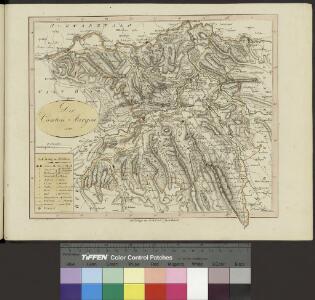
<<Der>> Canton Aargau
1 : 230000 1 Karte gez. u. gest. v. J.J. Scheurmann [Orell Füssli & Cp.], [Zürich]
<<Der>> Canton Aargau
1 : 230000 1 Karte gez. u. gest. von J.J. Scheurmann Orell Füssli & Cp., Zürich
<<Der>> Canton Aargau
1 : 230000 1 Karte gez. u. gest. von J.J. Scheurmann [Orell Füssli & Cp.], [Zürich]
Kanton Aargau: Trigonometrisches Netz
1 : 125000 Ohne Datumsangabe.
Karte des Kantons Aargau
1 : 250000 1 Karte J. Wurster & Comp., Winterthur
<<Der>> Canton Aargau
1 : 230000 1 Karte gez. u. gest. v. J.J. Scheurmann Orell, Füssli & Cp., Zürich
Nivellements-Karte des Cantons Aargau
1 : 125000 Michaelis, Ernst Heinrich [Aargauische Militär-Kommission]
Aargau
1 : 1450000 [Stumme Kartenskizzen der ganzen Schweiz und der einzelnen Kantone zu Unterrichtszwecken] Schulbuchhandlung Antenen
<<Der>> Canton Aargau
1 : 230000 1 Karte gez. u. gest. v. J.J. Scheurmann Orell, Füssli & Cp., Zürich
Trigonometisches Netz zur topographischen Karte des Cantons Aargau
1 : 125000 None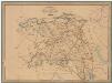
Kanton Aargau: Trigonometrisches Netz
Benz, Joh., Ingenieur
Taschen-Atlas der Schweiz
1 Atlas (25 S., 20 Taf.) gezeichnet und gestochen von Emil Wagner = Atlas de poche de la Suisse : 26 cartes en couleurs / dessinées et gravées par Émile Wagner Eggimann, Genf
Zürich 155, uit: Special-Karte von Mittel-Europa / nach amtlichen Quellen bearbeitet von W. Liebenow
1 : 300000 titelvariant: W. Liebenow's Mittel-Europa; Annotatie: Titel boven de bladen: W. Liebenow's Mittel-Europa Johannes Wilhelm Liebenow 1822-1897 Frankfurt a. M. : Ludwig Ravenstein
Zürich 155, uit: [W. Liebenow's Special-Karte von Mittel-Europa]
1 : 300000 titelvariant: W. Liebenow's Mittel-Europa; Annotatie: Titel boven de bladen: W. Liebenow's Mittel-Europa Johannes Wilhelm Liebenow 1822-1897 Hannover : Hermann Oppermann
Topographische Karte der Schweiz (Dufour-Karte): Den Kanton Zürich betreffende Blätter: Blatt VIII: Aarau, Luzern, Zug, Zürich
1 : 100000 Erstausgabe 1861; Nachführung 1866. Leitung: Dufour, Guillaume-Henri (1787-1875), General, Politiker, Ingenieur und Kartograf, von Genf; Eidgenössisches Topographisches Bureau, in Genf Stich: Müllhaupt, Heinrich (1820-1894), Kupferstecher und Kartograf, von Hofstetten; Stempelmann, J. (1835-1887) Druck: Koegel, Henri (1816-1867)
Le canton de Zurich
1 Karte : Kupferdruck ; 14 x 18 cm s.n.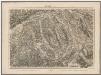
Topographische Karte der Schweiz (Dufour-Karte): Den Kanton Zürich betreffende Blätter: Blatt VIII: Aarau, Luzern, Zug, Zürich
1 : 100000 Erstausgabe 1861. Leitung: Dufour, Guillaume-Henri (1787-1875), General, Politiker, Ingenieur und Kartograf, von Genf; Eidgenössisches Topographisches Bureau, in Genf Stich: Müllhaupt, Heinrich (1820-1894), Kupferstecher und Kartograf, von Hofstetten; Stempelmann, J. (1835-1887) Druck: Koegel, Henri (1816-1867)
<<Die>> Cantone Solothurn und Basel
1 : 275000 1 Karte gest. v. J.J. Scheurmann Orell Füssli & Cp., Zürich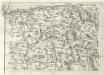
Geographica Provinciarum Sveviae Descriptio =
Mollova mapová sbírka Hurter, Johann Christoph Bodenehr, Johann Georg
Topographische Karte der Schweiz
1 : 100000 25 Karten vermessen und hrsg. auf Befehl der Eidgenössischen Behörden ; aufgenommen unter der Aufsicht des Generals G.H. Dufour Eidg. Topographisches Bureau, [Genève], [später: Bern]
Topographische Karte der Schweiz (Dufour-Karte), Kartenzusammensetzungen: Den Kanton Zürich betreffende Blätter: Aarau
Eidgenössische Landestopographie, in Köniz-Wabern
Blatt VIII: Aarau, Luzern, Zug, Zürich, uit: Topographische Karte der Schweiz / vermessen und hrsg. ... unter Aufsicht des Generals G.H. Dufour
1 : 100000 Annotatie: Met plaatsnamenregister (bl. V), bladwijzer (bl. XXI) en hoogteregister (bl. XXV); Voor aanwezige bladen zie overzichtsblad Dufour, G. H. [Bern : Eidg. Topogr. Bureau]
Atlas der alten Eidgenossenschaft in 20 Karten: Kanton Solothurn
Originaltitel: Canton Solothurn sive Pagus Helvetiae Solodurensis cum Confinibus. Mit Erklärung der Zeichen. Zeichnung: Walser, Gabriel (1695-1776), reformierter Pfarrer, von Teufen AR Herausgeber: Homännische Erben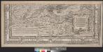
Eigentliche Verzeichnuss der Stätten, Graffschafften, und Herrschafften, welche in der Statt Zürich Gebiet und Landschafft gehörig seind
1 : 56000 1 Karte auf 16 Bl. [gerissen durch Josen Murern]
Atlas novus Reipublicae Helveticae
1 Atlas ([40] Bl., 97 S.) bey Orell, Gessner und Compagnie, Zürich
Atlas der alten Eidgenossenschaft in 20 Karten: Kanton Luzern
Originaltitel: Canton Lucern sive Illustris Helvetiorum Respublica Lucernensis cum Subditis suis et Confinibus. Mit Erklärung der Zeichen sowie Nebenkarte von Griessenberg im Thurgau. Zeichnung: Walser, Gabriel (1695-1776), reformierter Pfarrer, von Teufen AR Herausgeber: Homännische Erben
<<Die>> Cantone Solothurn und Basel
1 : 275000 1 Karte gest. v. J.J. Scheurmann Orell, Füssli & Cp., Zürich