Maps of Jura

<<Le>> canton de Vaud
1 : 390000 1 Karte dessiné par H. Keller ; gravé par J.J. Scheurmann [Orell Fussli et Comp.], [Zurich]
Carte des cantons de Genève, Vaud, Neuchâtel et Fribourg
1 : 250000 1 Karte Topogr. Anstalt von Wurster, Randegger und Co. Wurster, Zürich
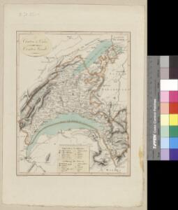
<<Das>> Wiflispurgergow
1 : 500000 1 Karte [von Johannes Stumpf] [Christoph Froschauer oder Johann Wolf], [Zürich]
Carte de Suisse suivant sa nouvelle division en XVIII cantons formant la République Helvétique, 1
1 Blatt : chez F. Monty
<<Le>> canton de Vaud
1 : 390000 1 Karte dessiné par H. Keller ; gravé par J.J. Scheurmann Orell Fussli et Comp., Zurich
<<Le>> canton de Vaud
1 : 390000 1 Karte dessiné par H. Keller ; gravé par J.J. Scheurmann Orell Fussli et Comp., Zurich
<<Le>> canton de Vaud
1 : 390000 1 Karte dessiné par H. Keller ; gravé par J.J. Scheurmann Orell Fussli & Comp., Zurich
Taschen-Atlas der Schweiz
1 Atlas (25 S., 20 Taf.) gezeichnet und gestochen von Emil Wagner = Atlas de poche de la Suisse : 26 cartes en couleurs / dessinées et gravées par Émile Wagner Eggimann, Genf
Carte topographique d'Allemagne contenant les cantons de Bern, et de Freyburg, les principautés de Neufchatel, et Vallangin, le territoire de Genève, et une partie comté de Bourgogne etc
1 : 210000 1 Karte fait par I. W. Iaeger chez l'Auteur., Francfort sur le Mein
<<Le>> canton de Vaud
1 : 390000 1 Karte dessiné par H. Keller ; gravé par J.J. Scheurmann Orell Fussli & Comp., Zurich
<<Le>> canton de Vaud
1 : 390000 1 Karte dessiné par H. Keller ; gravé par J.J. Scheurmann Orell Fussli & Comp., Zurich
Carte topographique de la grande route de Berne à Genève, 1
2 Blätter : 35 x 42 cm Ochs
Atlas der Schweiz
1 : 450000 1 Atlas (18 Bl.) gez. u. gest. v. J. Scheurmann Orell Fussli, Zurich
Atlas de la Suisse
1 : 450000 1 Atlas (19 Bl.) dessiné par MM. H. Keller, Scheurmann, Pfyffer d'Altishofen, Osterwald, etc. ; gravé par M. Scheurmann Orell Füssli & Co., Zürich
Das Wiflispurgergow. [Karte], in: Theatrum orbis terrarum, sive, Atlas novus, Bd. 1, S. 300.
1 Karte aus Atlas Blaeu, Joan Blaeu, Willem Janszoon
[Keller's Reisekarte der Schweiz]
1 : 500000 1 Karte auf 6 Bl. gezeichnet v. H. Keller ; gest. v. J.J. Scheurmann [Keller], Zürich
Das Wiflispurgergow, ou le territoire d'Avenche
1 Karte : Kupferdruck ; 13 x 17 cm s.n.
Das Wiflispvrgergow
1 Karte : Kupferdruck ; 37 x 48 cm Mercator; Janssonius Joannis Janssonius excud
Das Wiflispvrgergow
1 Karte : Kupferdruck ; 36 x 47 cm Mercator; Schenk; Valck apud G. Valk et P. Schenk
Das Wiflispvrgergow
1 Karte : Kupferdruck ; 37 x 49 cm Blaeu; Mercator Guiljel. Blaeu excudit
Les Suisses Leurs Alliés et Leurs Suiets]
1 : 250000 Mollova mapová sbírka Jaillot, Alexis-Hubert Jaillot, Alexis Hubert
Das Wiflispurgergou [Karte], in: Gerardi Mercatoris Atlas, sive, Cosmographicae meditationes de fabrica mundi et fabricati figura, S. 267.
1 Karte aus Atlas Mercator, Gerhard Montanus, Petrus
Das Wiflispvrgergow
1 : 320000 Mollova mapová sbírka Mercator, Gerhard Schenk, Peter I
Nova Helvetiae Tabula Geographica
1 : 290000 Mollova mapová sbírka Scheuchzer, Johann Jakob Huber, Johann Heinrich Scheuchzer, Johann Jakob
Das Wiflispurgergow [Karte], in: Novus atlas absolutissimus, Bd. 4, S. 242.
1 Karte aus Atlas Janssonius Offizin
[Südwestschweiz]
1 Karte : Kupferdruck ; 43 x 70 cm s.n.
Officielle Eisenbahn-Karte der Schweiz
1 : 250000 Südwest-Blatt [s.n.]
Reisekarte der Schweiz
1 : 500000 1 Atlas (1, 6 Bl.) gezeichnet von H. Keller und gestochen von J. Scheurmann = Carte routière de la Suisse / dessinée par H. Keller et gravée par J. Scheurmann bey Fuessli und Comp., Zürich
Atlas der alten Eidgenossenschaft in 20 Karten: Republik Genf sowie Genferseeregion
Originaltitel: Carte du Lac de Geneve et des Pays circonvoisins avec le Territoire de la République de Geneve et du Plan de la ditte Ville. Mit Erklärung der Zeichen und Nebenkarte der Stadt Genf. Bearbeitung: Rizzi Zannoni, Joh. Ant., Professor der Mathematik und Geografie Herausgeber: Homännische Erben