Maps of Grisons

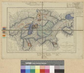
<<Der>> Canton Graubünden
1 : 470000 1 Karte R. am Stein delin. ; Scheurmann sculp. [Orell Füssli & Cp.?], [Zürich?]
<<Der>> Canton Graubünden
1 : 470000 1 Karte R. am Stein delin. ; Scheurmann sculp. [Orell Füssli & Cp.], [Zürich]
<<Der>> Canton Graubündten [i.e. Graubünden]
1 : 470000 1 Karte R. am Stein delin. ; Scheurmann sculp. [Orell Füssli & Comp.], [Zürich]
Atlas novus Reipublicae Helveticae
1 Atlas ([40] Bl., 97 S.) bey Orell, Gessner und Compagnie, Zürich
<<Der>> Kanton Graubünden
1 : 460000 1 Karte gez. von Rud. Gross Verlag von Ch. Beÿel, Zürich
Atlas de la Suisse
1 : 450000 1 Atlas (19 Bl.) dessiné par MM. H. Keller, Scheurmann, Pfyffer d'Altishofen, Osterwald, etc. ; gravé par M. Scheurmann Orell Füssli & Co., Zürich
Karte des Kantons Graubündten [i.e. Graubünden]
1 : 250000 1 Karte Topogr. Anstalt Winterthur, J. Schlumpf Geographisches Institut J. Meier, Zürich
<<Der>> Canton Graubünden
1 : 470000 1 Karte R. am Stein delin. ; Scheurmann sculp. [Orell Füssli & Cp.?], [Zürich?]
Graubünden
1 : 1450000 [Stumme Kartenskizzen der ganzen Schweiz und der einzelnen Kantone zu Unterrichtszwecken] Schulbuchhandlung Antenen
Parte orientale dell'Elvezia divisa ne' suoi cantoni
1 : 600000 1 Karte di nuova projezione / G. Zuliani inc.; G. Pitteri scr. presso Antonio Zatta, Venezia
<<Der>> Canton Graubünden
1 : 470000 1 Karte R. am Stein delin. ; Scheurmann sculp. [Orell Füssli & Cp.], [Zürich]
<<Der>> Canton Graubünden
1 : 470000 1 Karte R. am Stein delin. ; Scheurmann sculp. [Orell Füssli & Cp.], [Zürich]
Nova Helvetiae tabula geographica illustrissimis et potentissimis cantonibus et rebuspublicis reformatae religionis Tigurinae, Bernensi, Glaronensi, Basiliensi, Scaphusianae, Abbatis Cellanae
1 : 230000 1 Karte auf 4 Bl. dominis suis clementissimis humillime dicata a Ioh. Iacobo Scheuchzero Tigurino ; Ioh. Melch. Füsslin ornamenta pinx. ; Ioh. Henr. Huber et Eman. Schalch sculps. [Hofmeister], [Zürich]
Carte du réseau télégraphique Suisse
1 : 250000 Ostblatt Schweizerische Telegraphen- und Telephonverwaltung Kartographische Anstalt LIPS
Nova Helvetiae tabula geographica illustrissimis et potentissimis cantonibus et rebuspublicis reformatae religionis Tigurinae, Bernensi, Glaronensi, Basiliensi, Scaphusianae, Abbatis Cellanae
1 : 230000 1 Karte auf 4 Bl. dominis suis clementissimis humillime dicata a Ioh. Iacobo Scheuchzero Tigurino ; Ioh. Melch. Füsslin ornamenta pinx. ; Ioh. Henr. Huber et Eman. Schalch sculps. [Verlag nicht ermittelbar], [Zürich]
<<Der>> Canton Graubünden
1 : 470000 1 Karte R. am Stein delin. ; Scheurmann sculp. [Orell Füssli], [Zürich]
Karte des Kantons Graubundten [i.e. Graubünden]
1 : 250000 1 Karte J. Wurster u. Comp., Winterthur
<<Les>> Suisses, leurs alliés et leurs sujets
1 : 230000 1 Karte auf 4 Bl. par Iaillot chez l'auteur joignant les Grands Augustins aux deux Globes, Paris
Karte des Kantons Graubünden
1 : 250000 1 Karte Joh. Wurster & Comp., Winterthur
Rhaetia Foederata cum Confinibus et Subditis suis Valle Telina, Comitatu Clavennensi et Bormiensi, recenter et accuratißimé delineata
1 : 320000 Mollova mapová sbírka Walser, Gabriel Silbereisen, Andreas Seutter, Matthäus
Nouvelle carte géographique de la Suisse
1 : 600000 1 Karte auf 4 Bl. dressé par Jacq. Scheuchzer chez R. & J. Wetstein et Guil. Smith, Amsterdam
Uebersichtskarte der Central-Alpenbahnen Gotthard und Splügen im Vergleich zum Fusionsproject von La Nicca
1 : 380000 1 Karte Topogr. Anstalt v. Wurster, Randegger & Cie. [Verlag nicht ermittelbar], [Erscheinungsort nicht ermittelbar]
Carte de la Suisse
1 : 400000 1 Karte auf 2 Blättern de R. Leuzinger = Karte der Schweiz : Gewässer & Gebirge / von R. Leuzinger Verlag der Dalp'schen Buchhandlung, Bern
Carte de la nouvelle route depuis le Tyrol par le Col de Stilfs jusqu'a Milan
1 : 89500 1 Karte Hch Keller del ; Grimminger lith. Meyer, Zürich
<<Der>> Canton Graubünden
1 : 470000 1 Karte R. am Stein delin. ; Scheurmann sculp. [Orell Füssli], [Zürich]
<<Les>> Suisses, leurs alliés et leurs sujets
1 : 230000 1 Karte auf 4 Bl. par A.H. Iaillot, 1703 chez l'auteur joignant les grands Augustins aux deux globes, Paris
Alpinae seu Foederatae Rhaetiae Subditarumque ei Terrarum nova descriptio. [Karte], in: Novus Atlas, das ist, Weltbeschreibung, Bd. 1, S. 248.
1 Karte aus Atlas Blaeu, Joan Blaeu, Willem Janszoon
Reisekarte von Graubünden, Schweiz
1 : 300000 Graubünden (Švýcarsko) Direktion der Rhätischen Bahn