Maps of La Chaux-de-Fonds

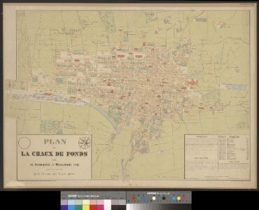
Plan de La Chaux de Fonds
1 : 3000 1 Plan complété et dessiné par J. Lalive ; [cartogr.:] Wurster, Randegger & Co. Direction des Travaux publics, [La Chaux-de-Fonds]


Atlas der Schweiz
1 : 450000 1 Atlas (18 Bl.) gez. u. gest. v. J. Scheurmann Orell Fussli, Zurich
<<Le>> canton de Neuchâtel
1 : 200000 1 Karte dessiné et gravé d'après la carte de Mr. d'Ostervald par G. Hegi [Orell Füssli & Comp.], [Zürich]
<<Le>> canton de Neuchâtel
1 : 200000 1 Karte dessiné et gravé d'après la carte de Mr. d'Ostervald par G. Hegi [Orell Füssli & Comp.], [Zürich]
<<Le>> canton de Neuchâtel
1 : 200000 1 Karte dessiné et gravé d'après la carte de Mr. d'Ostervald par G. Hegi [Orell Füssli & Comp.?], [Zürich?]
Carte de la souveraineté de Neufchatel et Valangin
1 Karte : Kupferdruck ; 40 x 57 cm L'Isle; Merveilleux Homännische Erben
Carte De La Souveraineté de Neuchatel et Vallangin
1 : 100000 Mollova mapová sbírka Seutter, Albrecht Carl Seutter, Albrecht Carl
Carte de la principauté de Neuchatel
1 : 10000 Neuchâtel (Švýcarsko : kanton) d'Ostervald, J. F. Berthier, Louis Alexandre
Carte de la souveraineté de Neuchatel et Vallangin
1 Karte : Kupferdruck ; 47 x 58 cm Seutter; Probst anjezo in Verlag bey Iohann Michael Probst chalcogr
Carte de la souveraineté de Neuchatel et Vallangin
1 Karte : Kupferdruck ; 46 x 63 cm L'Isle; Merveilleux; Liébaux; Buache Philippe Buache
Carte de la souveraineté de Neuchatel et Vallangin
1 Karte : Kupferdruck ; 46 x 63 cm L'Isle; Merveilleux; Liébaux Guillaume Delisle
canton de Neuchâtel
1 : 200000 Ostervald, Jean-Frédéric d' ; Hegi, Hans Kaspar [Orell Füssli]
Carte de la principauté de Neuchâtel
1 : 95000 Ostervald, Jean-Frédéric d' ; Aubert, J.B.L. Ch. Picquet
Carte de la principauté de Neufchatel et Vallengin
1 Karte : Kupferdruck ; 31 x 42 cm Clermont; Merveilleux; L'Isle; Glassbach s.n.
Carte du canton de Neuchâtel
1 : 150000 1 Karte dressé à l'usage des écoles et des familles par J. Randegger Delachaux et Niestlé, Neuchâtel
Neufchatel und Vallengin
1 Karte : Kupferdruck ; 15 x 19 cm Carl Ernst Bohn
Carte de la souveraineté de Neuchatel et Vallangin
1 Karte : Kupferdruck ; 46 x 63 cm L'Isle; Merveilleux chez Jean Cóvens et Corneille Mortier geographes
Carte de la Souveraineté de Neuchatel et Vallangin
1 : 100000 Mollova mapová sbírka Merveilleux, David François de Liébaux
Carte du canton de Neuchâtel
1 : 100000 1 Karte dessinée et gravée par E. Wagner Delachaux et Niestlé, Neuchâtel
<<Le>> canton de Neuchâtel
1 : 200000 1 Karte dessiné et gravé d'après la carte de Mr. d'Ostervald par G. Hegi [Orell Füssli], [Zürich]
<<Le>> canton de Neuchâtel
1 : 200000 1 Karte dessiné et gravé d'après la carte de Mr. d'Ostervald par G. Hegi [Orell Füssli], [Zürich]
Blatt VII: Porrentruy, Solothurn, uit: Topographische Karte der Schweiz / vermessen und hrsg. ... unter Aufsicht des Generals G.H. Dufour
1 : 100000 Annotatie: Met plaatsnamenregister (bl. V), bladwijzer (bl. XXI) en hoogteregister (bl. XXV); Voor aanwezige bladen zie overzichtsblad Dufour, G. H. [Bern : Eidg. Topogr. Bureau]
Pruntrut - Solothurn - Basel
1 : 100000 Kriegsdepot des Eidg. Topographischen Bureau's
[Neuchâtel, Genève]
1 : 1450000 [Stumme Kartenskizzen der ganzen Schweiz und der einzelnen Kantone zu Unterrichtszwecken] Schulbuchhandlung Antenen
Atlas de la Suisse
1 : 450000 1 Atlas (19 Bl.) dessiné par MM. H. Keller, Scheurmann, Pfyffer d'Altishofen, Osterwald, etc. ; gravé par M. Scheurmann Orell Füssli & Co., Zürich
<<Le>> canton de Neuchâtel
1 : 200000 1 Karte dessiné et gravé d'après la carte de Mr. d'Ostervald par G. Hegi [Orell Füssli], [Zürich]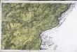
[Besançon]
1 Blatt : 62 x 91 cm s.n.