Maps of Sensebezirk

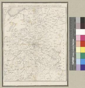
Karte des Kriegsschauplatzes im Canton Freyburg
1 : 100000 1 Karte Topogr. Anstalt v. Joh. Wurster u. Comp. [Friedrich Schulthess], [Zürich]
Topographische Karte des Kantons Freiburg: Blatt 3
1 : 50000 Mit Verzeichnis von Ortschaften mit französisch- und deutschsprachigen Namen. Stryienski, Casimir Napoléon Alexandre (1804-1875), Ingenieur, von Polen. Kupferstich: Delsol, Théodore (1819-1870), von Frankreich; Hacq, J. M.; Carré. V.
Carte topographique du canton de Fribourg
1 : 50000 Nordost-Blatt Stryienski, Alexandre ; Delsol, Théodore ; Hacq, J.M. ; Carré, ... F. Chardon ainé
<<Das>> Schlachtfeld von Murten 1476
1 : 50000 1 Karte de Mandrot [Feuerwerker-Gesellschaft], [Zürich]
Plan der Umgebungen von Freyburg
1 : 50000 1 Karte [Kartogr.:] Topogr. Anstalt v. J. Wurster u. Comp. [Stämpflische Verlagshandlung], [Bern]
Plan der Umgebungen von Freyburg
1 : 50000 1 Karte Topogr. Anstalt v. J. Wurster u. Comp. [Friedrich Schulthess], [Zürich]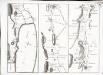
Carte topographique de la grande route de Berne à Genève, Blatt 4-6
3 Blätter : 35 x 48 cm Ochs
Environs de Fribourg
1 : 25000 1 Karte J.C. Werdmüller sc. [Verlag nicht ermittelbar], [Erscheinungsort nicht ermittelbar]
<<Das>> Schlachtfeld bey Laupen Ao. 1339
1 : 25000 1 Plan [Feuerwerkergesellschaft], [Zürich]
Plan d'Aventicum
1 : 5000 1 Plan dressé par Augte Rosset ; Etalb.t. topogr. de Wurster, Randegger & Cie. = Plan d'Avenches publié par l'Association pro Aventico, [Avenches]
Plan de la ville d'Avenghe en Suisse et de l'ençeinte d'Aventicvm Helvetorvm
1 Plan : Kupferdruck ; 35 x 39 cm Ritter; Fornerod; Eichler s.n.
Plan de la ville de Fribourg et des environs
1 : 5000 Sudan, J. ; Bertschy, J.B. Librairie Josué Labastrou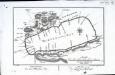
Grundriss, von dem Murten=See
1 Karte : Kupferdruck ; 16 x 25 cm Herrliberger; Vissaula D. Herrliberger exc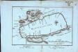
Grundriss, von dem Murten=See
1 Karte : Kupferdruck ; 16 x 25 cm Herrliberger; Vissaula D. Herrliberger exc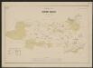
Uebersichtsplan der Gemeinde Bümpliz
1 : 10000 Feller, Karl Topogr. Anstalt v. Wurster, Randegger & Cie.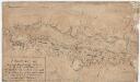
Laupen BE, Mühleberg BE: Als militärische Position zu verteidigendes Gebiet bei Laupen, Gümmenen und Marfeldingen; Situationsplan
Mit Legende. Lanz, Andreas (1740-1803), Geometer und Artilleriehauptmann, von Rohrbach BE
Blatt XII: Freyburg, Bern, uit: Topographische Karte der Schweiz / vermessen und hrsg. ... unter Aufsicht des Generals G.H. Dufour
1 : 100000 Annotatie: Met plaatsnamenregister (bl. V), bladwijzer (bl. XXI) en hoogteregister (bl. XXV); Voor aanwezige bladen zie overzichtsblad Dufour, G. H. [Bern : Eidg. Topogr. Bureau]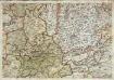
Inclitae Bernatum urbis, cum omni ditionis suae agro et provinciis delineatio chorographica, 9/10
2 Blätter : Adelbert Saueracher
Atlas der Schweiz
1 : 450000 1 Atlas (18 Bl.) gez. u. gest. v. J. Scheurmann Orell Fussli, Zurich
Canton Freyburg
1 : 270000 Scheuermann, Johann Jakob [Orell Füssli]
Carte du canton de Fribourg à l'usage des écoles
1 : 100000 Stryienski, Alexandre J. Wurster et Comp.
Carte archéologique du Canton de Fribourg
1 : 100000 Bonstetten, Gustav Karl <
Der Canton Freyburg
1 : 228000 Fribourg (Švýcarsko : kanton) Scheurmann, J. J.
Carte des alpes fribourgeoises
1 : 100000 1 Karte E. Wagner Josué Labastrou, Fribourg
Karte der westlichen Stockhornkette
1 : 50000 1 Karte bearbeitet von R. Leuzinger ; [Lith.:] Topogr. Anstalt v. Wurster, Randegger & Co. in Winterthur [Verlag der Expedition des Jahrbuches des S.A.C.], [Bern]
Topographische Karte des Kantons Freiburg: Blatt 1
1 : 50000 Stryienski, Casimir Napoléon Alexandre (1804-1875), Ingenieur, von Polen Kupferstich: Delsol, Théodore (1819-1870), von Frankreich; Hacq, J. M.; Carré. V.
Grundriss von dem Murten-See
1 : 50000 1 Karte des. pr Vissaula Herrliberger, Zürich
Gegend des Gefechtes am Donner-Bühl und im Jammerthal Ao. 1298
1 : 87000 1 Plan [Feuerwerkergesellschaft], [Zürich]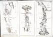
Carte topographique de la grande route de Berne à Genève, Blatt 1-3
3 Blätter : 35 x 49 cm Ochs