Maps of Bern

<<Der>> Canton Freyburg
1 : 270000 1 Karte gez. u. gest. von J.J. Scheurmann [Orell Füssli & Cp.], [Zürich]
[Fribourg, Solothurn]
1 : 1450000 [Stumme Kartenskizzen der ganzen Schweiz und der einzelnen Kantone zu Unterrichtszwecken] Schulbuchhandlung Antenen
Le Theatre de Bellone :
Mollova mapová sbírka Schenk, Pieter Braakman, Adriaan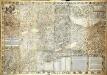
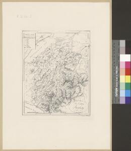
Inclitæ Bernatvm vrbis, cvm omni ditionis svæ agro et provinciis delineatio chorographica
1 Karte auf 18 Blatt : Kupferdruck ; 128 x 187 cm Schöpf; Martin; Krumm; Jobin; Saueracher; Meyer Albrecht Meyer
Inclitæ Bernatvm vrbis, cvm omni ditionis svæ agro et provinciis delineatio chorographica
1 Karte auf 18 Blatt : Kupferdruck ; je 46 x 65 cm Schöpf; Martin; Krumm; Jobin; Saueracher Adelbert Saueracher
[Exactissima Helvetiae, Rhaetiae, Valesiae ... tabula]
1 : 850000 9 Karten [Kopie von Adrian Braakman] [chez Pierre Schenk et Adrian Braakman], [Amsterdam]
Carte topographique d'Allemagne contenant les cantons de Bern, et de Freyburg, les principautés de Neufchatel, et Vallangin, le territoire de Genève, et une partie comté de Bourgogne etc
1 : 210000 1 Karte fait par I. W. Iaeger chez l'Auteur., Francfort sur le Mein
<<Der>> Canton Freyburg
1 : 270000 1 Karte gez. u. gest. von J.J. Scheurmann [Orell Füssli & Comp.], [Zürich]
Das Wiflispvrgergow
1 : 320000 Mollova mapová sbírka Mercator, Gerhard Schenk, Peter I
Das Wiflispurgergow, ou le territoire d'Avenche
1 Karte : Kupferdruck ; 13 x 17 cm s.n.
Das Wiflispvrgergow
1 Karte : Kupferdruck ; 37 x 48 cm Mercator; Janssonius Joannis Janssonius excud
Das Wiflispvrgergow
1 Karte : Kupferdruck ; 36 x 47 cm Mercator; Schenk; Valck apud G. Valk et P. Schenk
Das Wiflispvrgergow
1 Karte : Kupferdruck ; 37 x 49 cm Blaeu; Mercator Guiljel. Blaeu excudit
<<Le>> canton de Vaud
1 : 390000 1 Karte dessiné par H. Keller ; gravé par J.J. Scheurmann [Orell Fussli et Comp.], [Zurich]
Freyburg in der Schweiz
1 : 200000 1 Karte entworfen und bearbeitet von Woerl ; gestochen unter seiner Leitung 1835 ; Lithographie von B. Herder Herder, Freiburg im Breisgau
Das Wiflispvrgergov
1 Karte : Kupferdruck ; 34 x 46 cm Janssonius Joannes Janssonius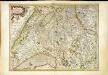
Das Wiflispvrgergov
1 Karte : Kupferdruck ; 34 x 46 cm Mercator; Hondius Henricus Hondius
Das Wiflispvrgergov
1 Karte : Kupferdruck ; 34 x 45 cm Mercator s.n.
Das Wiflispurgergow. [Karte], in: Theatrum orbis terrarum, sive, Atlas novus, Bd. 1, S. 300.
1 Karte aus Atlas Blaeu, Joan Blaeu, Willem Janszoon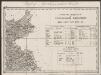
Das Wiflispurgergou [Karte], in: Gerardi Mercatoris Atlas, sive, Cosmographicae meditationes de fabrica mundi et fabricati figura, S. 267.
1 Karte aus Atlas Mercator, Gerhard Montanus, Petrus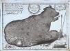
Nova ditionis Bernensis tabula geographica ursi effigie delineata
1 Karte : Kupferdruck ; 23 x 33 cm Störcklein s.n.
Nova ditionis Bernensis tabula geographica ursi effigie delineata
1 Manuskriptkarte : 23 x 33 cm Störcklein s.n.
Carte des cantons de Genève, Vaud, Neuchâtel et Fribourg
1 : 250000 1 Karte Topogr. Anstalt von Wurster, Randegger und Co. Wurster, Zürich

Das Wiflispurgergow [Karte], in: Novus atlas absolutissimus, Bd. 4, S. 242.
1 Karte aus Atlas Janssonius Offizin
Das Wiflispurgergow. [Karte], in: Novus Atlas, das ist, Weltbeschreibung, Bd. 1, S. 251.
1 Karte aus Atlas Blaeu, Joan Blaeu, Willem Janszoon
Das Wiflispurgergou [Karte], in: Gerardi Mercatoris et I. Hondii Newer Atlas, oder, Grosses Weltbuch, Bd. 1, S. 262.
1 Karte aus Atlas Mercator, Gerhard und Hondius, Jodocus Jansson, Jan
Carte topographique de la grande route de Berne à Genève, 1
2 Blätter : 35 x 42 cm Ochs
DAS | WIFLISPVR- | GERGOW
Gerardo Mercatore Auctore. Guiljel. Blaeu excudit