Project
Community
News
My maps
Carte cataloguée
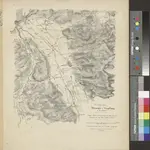
Situationsplan von Oftringen u. Umgebung im Cant. Aargau
Titre complet:
Situationsplan von Oftringen u. Umgebung im Cant. Aargau
Éditeur:
J. Wurster u. Comp., Winterthur
Taille physique:
20 x 30 cm
Échelle de la carte:
1:25 000
Catalog
dx.doi.org
L'histoire