Maps of Zürich
Kantonale Gewerbe-Ausstellung mit eidg. Spezial-Ausstellung Zürich 1894
1 : 15000 1 Plan
[Zürich]
1 : 15000 1 Plan
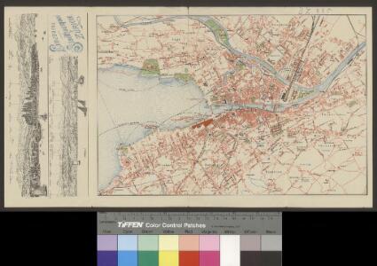
Uebersichtsplan der Stadt Zürich nebst Umgebung
1 : 6600 Orell Füssli & Co.
Uebersichtsplan der Stadt Zürich & Umgebung
1 : 7500 1 Plan nach dem grossen offiziellen Plane entworfen und lithographirt von J.J. Hofer
Offizieller Uebersichtsplan der Stadt Zürich
1 : 7500 1 Karte hrsg. Vermessungsamt der Stadt Zürich
Projekierte Einmündung der rechtsseitigen Seebahn in den Nordost-Bahnhof in Zürich; Übersichtsplan
1 : 10000 Ohne Datumsangabe. Wurster, Randegger und Cie., in Winterthur
Offizieller Uebersichtsplan der Stadt Zürich
1 : 7500 1 Plan hrsg. Vermessungsamt der Stadt Zürich
Geologischer Plan von Zürich und Umgebung
1 : 10000 1 Karte [Arnold Escher von der Linth] ; Wurster, Randegger & Cie.
Strassen-Übersichtsplan von Zürich und Umgebung
1 : 8800 1 Plan gez. von Hch. Keller
Strassen-Uebersichtsplan von Zürich und Umgebung
1 : 8800 1 Plan gezeichnet von Hch. Keller
Plan von Zürich & Umgebung
1 : 18000 1 Plan
Übersichtsplan der Stadt Zürich
1 : 7500 1 Plan
Uebersichtsplan von Zürich & Umgebung
1 : 5000 1 Plan autographirt im Novb. 1867 von Ad. Vögeli
Offizieller Uebersichtsplan der Stadt Zürich
1 : 7500 Topogr. Anstalt Winterthur: J. Schlumpf, vormals Wurster, Randegger & Cie.
Uebersichtsplan der Stadt Zürich & Umgebung
1 : 7500 1 Plan nach dem grossen offiziellen Plane entworfen und lithographiert von J.J. Hofer
Plan von Zürich & Umgebung
1 : 16000 1 Plan
Strassen-Übersichtsplan von Zürich und Umgebung
1 : 8800 1 Plan gez. von H. Keller
Plan der Stadt Zürich
1 : 10000 Mit roter Einzeichnung von Bahn- und Quaiprojekten. Ohne Datumsangabe. Wurster, Randegger und Cie., in Winterthur
Uebersichtsplan von Zürich & Umgebung
1 : 5000 1 Plan autographirt im Novb. 1867 von Ad. Vögeli
Übersichtsplan von Zürich und Umgebung
1 : 5000 Vögeli, Arnold (geb. 1826)
Uebersichtsplan der Stadt Zürich & Umgebung
1 : 7500 1 Plan nach dem grossen offiziellen Plane entworfen & lithographirt von J.J. Hofer
Plan von Zürich und Ausgemeinden
1 : 10000 1 Plan
[Uebersichtsplan der Stadt Zürich & Umgebung]
1 : 7500 1 Plan Lithogr. J.J. Hofer
Uebersichtsplan von Zürich & Umgebung
1 : 5000 1 Plan [autographirt Ad. Vögeli]
Plan von Zürich und Umgebung mit Angabe der Projekte für die Einmündung der rechtsseitigen Seebahn in den Nordostbahnhof
1 : 10000 Ohne Datumsangabe. Wurster, Randegger und Cie., in Winterthur
Plan von Zürich und Umgebung
1 : 10000 1 Plan
Plan von Zürich & Umgebung
1 : 10000 1 Plan
Plan von Zürich & Umgebung
1 : 12500 1 Plan
Plan der Stadt Zürich u. Umgebung nach dem grossen offiziellen Plane
1 : 10000 1 Plan