Maps of Zürich

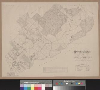
Uebersichtsplan der Gemeinde Fluntern
1 : 5000 1 Plan aufgenommen im Jahr 1863 & 1864 von Haas ; gez. von H. Weiss-Keiser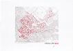
Historische Bauzustände der Zürcher Aussenquartiere in 48 Blättern: Fluntern im Jahre 1932 auf einem Plan von 1986; Übersichtsplan
1 : 5000 Haas, B.; Lehmann, M.; Romatko, Carlo; Suter-Cutler, E. Zeichnung: Flachsmann, M.; Frei, M.; Romatko, Carlo; Steiner, J.; Werffeli, A. Baugeschichtliches Archiv der Stadt Zürich, in Zürich Bewilligung: Vermessungsamt der Stadt Zürich, in Zürich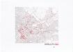
Historische Bauzustände der Zürcher Aussenquartiere in 48 Blättern: Fluntern im Jahre 1890 auf einem Plan von 1986; Übersichtsplan
1 : 5000 Haas, B.; Lehmann, M.; Romatko, Carlo; Suter-Cutler, E. Zeichnung: Flachsmann, M.; Frei, M.; Romatko, Carlo; Steiner, J.; Werffeli, A. Baugeschichtliches Archiv der Stadt Zürich, in Zürich Bewilligung: Vermessungsamt der Stadt Zürich, in Zürich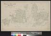
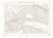
Waldungen der Stadtbürgergemeinde Zürich
1 : 5000 1 Karte gez. H. Honegger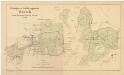
Horgen, Langnau am Albis, Thalwil, Hottingen, Zürich: Staatswaldungen, Genossenschaftswaldungen und Zürcher Stadtwaldungen: Zürich: Der Stadtbürgergemeinde Zürich gehörende Waldungen Geissberg, Zürichberg, Buschberg; Grundriss
1 : 5000 Mit Angabe der Nummern und Grenzen der Waldabteilungen. Mit nachträglich mit Grafitstift angebrachten Einzeichnungen. Zeichnung: Honegger, Huldreich, von Zürich Druck: Hofer und Burger, in Zürich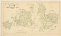
Horgen, Langnau am Albis, Thalwil, Hottingen, Zürich: Staatswaldungen, Genossenschaftswaldungen und Zürcher Stadtwaldungen: Zürich: Der Stadtbürgergemeinde Zürich gehörende Waldungen Geissberg, Zürichberg, Buschberg; Grundriss
1 : 5000 Mit Angabe der Nummern und Grenzen der Waldabteilungen. Zeichnung: Honegger, Huldreich, von Zürich Druck: Hofer und Burger, in Zürich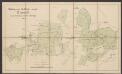
Waldungen der Stadtbürgergemeinde Zürich
1 : 5000 Honegger, H. Hofer & Burger
Fluntern, Hottingen: Gemeinden; Übersichtsplan
1 : 4000 Mit Angabe der Hausnummern. Ohne Datumsangabe.
Fluntern und Hottingen
1 : 4000 1 Plan
Historische Bauzustände der Zürcher Aussenquartiere in 48 Blättern: Fluntern im Jahre 1812 auf einem Plan von 1986; Übersichtsplan
1 : 5000 Haas, B.; Lehmann, M.; Romatko, Carlo; Suter-Cutler, E. Zeichnung: Flachsmann, M.; Frei, M.; Romatko, Carlo; Steiner, J.; Werffeli, A. Baugeschichtliches Archiv der Stadt Zürich, in Zürich Bewilligung: Vermessungsamt der Stadt Zürich, in Zürich
Übersichtsplan von Zürich und Umgebung
1 : 5000 Nordost-Blatt None
Uebersichtsplan von Zürich & Umgebung
1 : 5000 1 Plan in 4 Teilen autographiert im Novb. 1867 von Ad. Vögeli
Horgen, Langnau am Albis, Thalwil, Hottingen, Zürich: Staatswaldungen, Genossenschaftswaldungen und Zürcher Stadtwaldungen: Zürich: Waldungen Oberholz, Heubeeribüel (Heubeerenbühl), Rossweid, Chlösterli (Neu Klösterli), Chlosterholz (Klosterholz), Lindenzelg; Grundriss
1 : 2000 Erstellt auf der Basis eines Übersichtsplans der Gemeinde Fluntern. Fröhlich, Jakob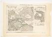
Horgen, Langnau am Albis, Thalwil, Hottingen, Zürich: Staatswaldungen, Genossenschaftswaldungen und Zürcher Stadtwaldungen: Zürich: Landstücke beim Dolder in Hottingen und bei Rüti in Witikon; Grundrisse
1 : 2500 Mit Verzeichnis der Flächeninhalte und Angabe der Beschaffenheit der grün markierten Parzellen. Ohne Erstellungsdatumsangabe. Ausgangsplan: Blatt 34 des Übersichtsplans der Stadt Zürich. Ausgangsplan: Vermessungsamt der Stadt Zürich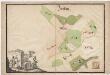
Fluntern: Dem Obmannamt gehörender Lehenhof auf dem Zürichberg beim alten Klösterli; Grundriss
Mit Darstellung dreier Vermesser bzw. Kartografen bei der Arbeit. Ohne Datumsangabe.
Übersichtsplan der Stadt Zürich und der umliegenden Gemeinden in 23 Blättern: Blatt XVIII: Teile von Hirslanden, Hottingen und Fluntern
1 : 2500 Vermessungsamt der Stadt Zürich Topographische Anstalt J. Schlumpf, in Winterthur
Übersichtsplan der Stadt Zürich und der umliegenden Gemeinden in 23 Blättern: Blatt XVIII: Teile von Hirslanden, Hottingen und Fluntern
1 : 2500 Mit Höhenkurven. Vermessungsamt der Stadt Zürich Kartographia Winterthur A.G., in Winterthur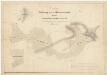
Hirslanden, Hottingen, Oberstrass, Schwamendingen, Zürich: Spital- und Staatswaldungen auf dem Zürichberg und dem Adlisberg: Oberstrass, Schwamendingen: Kantonsspitalwaldungen Streitholz, Brunnhölzli und Strickhölzli auf dem Zürichberg; Grundrisse (Tab. V)
1 : 2400 Erstellt auf der Basis der in der Spitalamtskanzlei befindlichen Grundrisssammlung. Mit handschriftlichen Eintragungen und Einzeichnungen, welche nach der eigentlichen Zeichnung des Plans, d. h. nach 1845, mit Tinte und Grafitstift angebracht wurden. Obrist, Kaspar (1791-1869), Forstmeister des 1. Kreises des Kantons Zürich und Geometer, von Zollikon
Hottingen: Dem Spital Zürich gehörende Waldungen auf dem Zürichberg, Forsteinteilung im Jahre 1801; Grundriss
Mit Verzeichnis der Flächeninhalte der einzelnen Waldabteilungen. Hotz, Heinrich (1768-1813), von Oberrieden; Bluntschli
Fluntern, Hottingen, Unterstrass, Zürich: Stadt-, Gemeinde- und Genossenschaftswaldungen: Zürich: Hottinger Gemeindewaldungen Pilgerholz, Stotzen, Hottingerberg, Rüti, Hubrüti; Übersichtsplan
1 : 2000 Kopie eines am 19.06.1893 von Jakob Fröhlich verfertigten Originalplans. Ohne Erstellungsdatumsangabe. Mit nachträglich angebrachten farbigen Einzeichnungen. Katastergeometer, Tiefbauamt V der Stadt Zürich
Hottingen: Dem Spital Zürich gehörende Waldungen im Grüt-Holz und Gumlen; Grundriss
Mit Legende. Hotz, Heinrich (1768-1813), von Oberrieden
Fluntern: Dem Obmannamt gehörende Lehenhöfe Tobelhof und Zürichberg; Grundriss
Mit dem Wappen des Obmannamts sowie dem Familienwappen der Heidegger. Ohne Datumsangabe.
Verschiedene Gemeinden: Sämtliche dem Spital Zürich gehörende Waldungen; Grundrisse: Grütholz
Übersichtsplan der Stadt Zürich in 57 Blättern, Blatt 34: Teil von Hottingen beim Kunsteisfeld Dolder und Umgebung
1 : 2500 Vermessungsamt der Stadt Zürich
Horgen, Langnau am Albis, Thalwil, Hottingen, Zürich: Staatswaldungen, Genossenschaftswaldungen und Zürcher Stadtwaldungen: Zürich: Waldungen Pilgerholz, Grüt, Dreiwisen (Dreiwiesen), Widen (Weiden), Rebrain, Rainriegeln, Buschberg; Grundriss
1 : 2000 Erstellt auf der Basis eines Übersichtsplans der Gemeinde Hottingen. Fröhlich, Jakob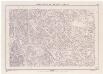
Übersichtsplan der Stadt Zürich in 57 Blättern, Blatt 33: Teile des Stadtzentrum und von Fluntern zwischen Central und Meteorologischer Zentralanstalt
1 : 2500 Nachführungsstand ca. 1983. Vermessungsamt der Stadt Zürich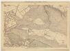
Zürich: Drahtschmidli am Sihlquai; Dispositionspläne: Blatt 10: Dispositionsplan
1 : 2500 Mit handschriftlicher Eintragung der verschiedenen Zonen. Ausgangsplan: Übersichtsplan der Stadt Zürich von 1937. Ausgangsplan Zeichnung: Vermessungsamt der Stadt Zürich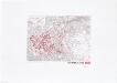
Historische Bauzustände der Zürcher Aussenquartiere in 48 Blättern: Hottingen im Jahre 1890 auf einem Plan von 1986; Übersichtsplan
1 : 5000 Haas, B.; Lehmann, M.; Romatko, Carlo; Suter-Cutler, E. Zeichnung: Flachsmann, M.; Frei, M.; Romatko, Carlo; Steiner, J.; Werffeli, A. Baugeschichtliches Archiv der Stadt Zürich, in Zürich Bewilligung: Vermessungsamt der Stadt Zürich, in Zürich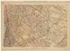
Zürich: Drahtschmidli am Sihlquai; Dispositionspläne: Blatt 11: Dispositionsplan
1 : 2500 Mit handschriftlicher Eintragung der verschiedenen Zonen. Ausgangsplan: Übersichtsplan der Stadt Zürich von 1935. Ausgangsplan Zeichnung: Vermessungsamt der Stadt Zürich