Maps of Zürich

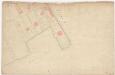
Plan der Liegenschaften im Bleicherweg bei Zürich
1 : 1000 1 Plan
[Zürich-Enge, projektierte Quaianlagen]
1 : 1000 1 Plan
[Zürich-Selnau]
1 : 1000 1 Plan auf 2 Blättern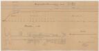
Enge: Schanzengraben vom Zürichsee bis zur Bleicherwegbrücke; Längsprofil und Situationsplan (Zürichsee-Gebiet Nr. 13 a)
1 : 1000 Mit Originalvermerk: Regierungsbeschluss v. 15. II. 1883. Bürkli, Arnold (1833-1894), leitender Ingenieur der Quaibaukommission der Gemeinden Enge, Zürich und Riesbach, von Zürich, in Zürich
Zürich: Projektierte Korrektion des Schanzengrabens; Grundriss
Ohne Datumsangabe.
Zürich: Schanzengebiet der Kleinen Stadt vom Zürichsee bis zum Katz-Bollwerk bzw. bis zur Sihl; Grundriss
Zürich: Gassenplan der Kleinen Stadt, Blatt 1 (Talgasse)
1 : 500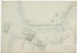
Zürich: Befestigungsanlage von der Schiffsschanze bis zum Bären-Bollwerk; Grundriss (Nr. 1)
1 : 500 Frey, J. J., Ingenieur
[Zürich]
1 : 1000 12 Pläne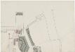
Beim Spitz-Bollwerk
Möglicherweise: Breitinger, David (1763-1834), Feinmechaniker und Zeugherr, von Zürich
Enge: Parzellierung für das Villenquartier; Grundriss
1 : 1000 Hofer, J. J.
Enge: Riedtligraben; Grundriss
1 : 1000 Handgezeichnete Katasterkopie. Hohl, A., Kreisingenieur des 1. Kreises des Kantons Zürich, von Grub AR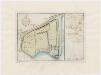
Enge: Dem Spital Zürich gehörendes Lehen auf dem Riet; Grundriss
Mit Legende. Müller, Johannes (1733-1816), obrigkeitlicher Ingenieur des Zürcher Stadtstaats, von Zürich
[Zürich]
1 : 1000 12 Pläne
Zürich: Projektierte Strassen über den Schanzengraben von Selnau bis Thalacker; Situationsplan
1 : 500 Vermutlich: HP.
Zürich: Schanzenlehen Nr. 13 Kleine Stadt, beim Bollwerk am Schanzengraben-Spitz; Grundriss
Mit Erläuterungen. Müller, Johannes (1733-1816), obrigkeitlicher Ingenieur des Zürcher Stadtstaats, von Zürich
Enge: Dem Spital Zürich gehörendes Lehen auf dem Riet; Grundriss
Mit Legende. Däniker (vermutlich: Dänniker, J. Martin)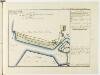
Zürich: Dem Spital Zürich gehörende Lehen in den Fortifikationswerken; Ansichten, Grundrisse und Schnitte: Schanzenlehen Nr. 11 Kleine Stadt, zwischen Wollishofer-Steg und Zürichsee; Grundriss
Mit Erläuterungen. Müller, Johannes (1733-1816), obrigkeitlicher Ingenieur des Zürcher Stadtstaats, von Zürich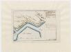
Zürich: Schanzenlehen Nr. 10 Kleine Stadt, bei der Unteren Bleiche; Grundriss
Mit Erläuterungen. Müller, Johannes (1733-1816), obrigkeitlicher Ingenieur des Zürcher Stadtstaats, von Zürich
Zürich: Schanzenlehen Nr. 14 Kleine Stadt, zwischen Bleicherweg und Bär-Bollwerk; Grundriss
Mit Erläuterungen. Müller, Johannes (1733-1816), obrigkeitlicher Ingenieur des Zürcher Stadtstaats, von Zürich.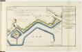
Zürich: Dem Spital Zürich gehörende Lehen in den Fortifikationswerken; Ansichten, Grundrisse und Schnitte: Schanzenlehen Nr. 8 Kleine Stadt, zwischen Bleikerweg und Albisstrasse; Grundriss
Mit Erläuterungen. Müller, Johannes (1733-1816), obrigkeitlicher Ingenieur des Zürcher Stadtstaats, von Zürich
Zürich: Schanzenlehen Nr. 9 Kleine Stadt, bei der Oberen Bleiche; Grundriss
Mit Erläuterungen. Müller, Johannes (1733-1816), obrigkeitlicher Ingenieur des Zürcher Stadtstaats, von Zürich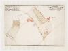
Enge, Zürich: Dem Spital Zürich gehörende Reben im Neugut und in Selnau; Grundriss

Zürich: Gassenplan der Kleinen Stadt, Blatt 2 (Talgasse-Stadthausquai)
1 : 500 Sulzberger, Johann Jakob (1802-1855), Ingenieur, von Frauenfeld TG
Situationsplan vom Stadthaus
1 : 500 1 Plan
Zürich: Dem Spital Zürich gehörende Lehen in den Fortifikationswerken; Ansichten, Grundrisse und Schnitte: Schanzenlehen Nr. 13 Kleine Stadt, beim Bollwerk am Schanzengraben-Spitz; Grundriss
Mit Erläuterungen. Müller, Johannes (1733-1816), obrigkeitlicher Ingenieur des Zürcher Stadtstaats, von Zürich
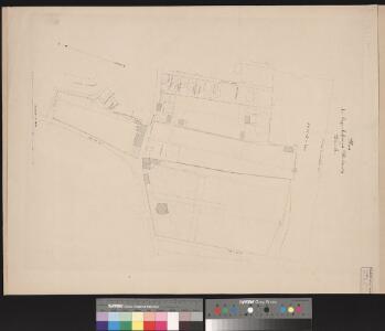
Enge: Gemeinde; Katasterpläne und Kataster-Ergänzungspläne: Blatt II: Gegend bei Brandschenkestrasse, Stockerstrasse, Bleicherweg, Glärnischstrasse und Schanzengraben; Situationsplan
1 : 500 Oppikofer, F.
Enge: Gemeinde; Katasterpläne und Kataster-Ergänzungspläne: Ergänzungsblatt II: Gegend bei Brandschenkestrasse, Tödistrasse, Stockerstrasse, Gartenstrasse, Bleicherweg und Claridenstrasse; Situationsplan
1 : 500 Oppikofer, F.
Zürich: Bauplätze zwischen Fröschengraben und Seegasse bzw. Fröschengraben und Bleicherweg; Grundriss
Ohne Datumsangabe.