Maps of Zurich

<<Der>> Canton Zürich nach seinen Capituls und Bezirks Abtheilungen
1 : 300000 1 Karte CE.
<<Das>> Zürichgebiet nach Murdochs Entwerfungsart
1 : 300000 1 Karte
Karte vom Canton Zürich 1795
1 : 600000 1 Karte M.P. f.
Tabula topographica parochiarum synodo Tigurinae obstrictarum opera
1 : 190000 1 Karte Joh. Heinr. Freytag
Handkarte des Ktns. Zürich und seiner Umgebung
1 : 150000 1 Karte bearbeitet nach der neuen Wandkarte des Kt. Zürich von J. Schlumpf
<<Das>> Zürichgebiet nach Murdochs Entwerfungsart
1 : 300000 1 Karte
Canton Zürich
1 : 230000 1 Karte gezeichnet und herausgegeben von Hch. Keller ; gest. v. J. Scheurmann
<<Das>> Zürichgebiet nach Murdochs Entwerfungsart
1 : 300000 1 Karte
Tabula topographica parochiarum synodo Tigurinae obstrictarum
1 : 200000 1 Karte opera Joh. Heinr. Freytag, Chalcogr.
Tabula topographica parochiarum synodo Tigurinae obstrictarum
1 : 200000 1 Karte opera Joh. Heinr. Freytag, Chalcogr.
Neue und exakte geographische Tabelle der Gebiete der Stadt Zürich
1 : 740000 Originaltitel: Neue und Exacte Geograph. Tabell von der Statt Zürich gebiett nach derselben inneren und ausseren habenden Vogteyen eingerichtett. Mit Wappen der Vogteien. Zeichnung und Stich: Lobeck, Tobias Verlag: Hofmeister, Johannes, Buchbinder, in Zürich
Zürich Gebiet
1 : 250000 1 Karte J.H. Streulinus inv. ; J.G. Seiller sculpsit
<<Der>> Canton Zürich
1 : 230000 1 Karte J.J. Scheurmann sc.
Distanzenkarte von der Schweiz
1 : 200000 1 Karte in 8 Teilen nach den besten Hülfsquellen bearb. von R. Huber Wagner, Bern
Canton Zürich sive illustris Helvetiorum respublica Tigurina cum subditis suis et confinibus
1 : 275000 1 Karte [Gabriel Walser?]
Tabula topographica parochiarum synodo Tigurinae obstrictarum opera
1 : 190000 1 Karte Joh. Heinr. Freytag
<<Der>> Kanton Zürch [i.e. Zürich]
1 : 250000 1 Karte [hrsg. von Franz Johann Joseph von Reilly]
Canton Zürich sive illustris Helvetiorum respublica Tigurina cum subditis suis et confinibus
1 : 275000 1 Karte [Gabriel Walser?]
Militärkarte der Nordostschweiz
1 : 52000 Originaltitel: Der Uralten Loblichen Statt Zürich Graffschaften, Herrschaften, Stett und Land diser zyt von ihnen beherrschet, auch derselben benachbarte verbündet und angehörige, und inen sonst mit Burgrecht und Eigenschafft zugethan als Appenzell, Apt und Statt S. Gallen, die Grafschafften Turgow, Baden, Toggenburg, Sargans, Windegg, Werdenberg und das Rhynthal. So by uralten Zyten in pagum Tigurinum gedient, an ietzo aber in andrem stand und wesen sind, ihr allerseits orth und glegenheit in grund gelegt und lebendig vor augen gestelt. Anno 1620. Die Karte und ausführliche Erläuterungen, das Defensional von Hans Haller, wurden am 11.10.1620 dem Rat von Zürich übergeben. Aufnahme: Nüscheler, Christoph (1589-1661), Glas- und Flachmaler sowie Quartiermeister, von Zürich; Nüscheler, Hans Jakob (1583-1654), Glas- und Flachmaler sowie Quartiermeister, von Zürich; Oeri, Hans, Quartiermeister; Ringgli, Gebhard, Quartiermeister; Haldenstein, Hans Ulrich, Quartiermeister; Gyger, Hans Conrad, andere Schreibweisen: Geiger, Geyger, (1599-1674), Kartograf, Ingenieur und Quartiermeister, von Zürich; Haller, Hans, Stadtingenieur; Bürkli, Jakob, Stadtingenieur Zeichnung: Gyger, Hans Conrad, andere Schreibweisen: Geiger, Geyger, (1599-1674), Kartograf und Ingenieur, von Zürich
Carte de la Suisse avec les plans des cheflieux des 22 cantons
1 : 200000 1 Karte auf 8 Bl. dessinée et publié par Henri Keller ; Lithogr. von J. Schweizer = Charte der Schweiz mit den Grundrissen der Hauptorte der 22 Cantone Keller, Zürich
Wandkarte der Schweiz
1 : 200000 1 Karte auf 8 Blättern J.M. Ziegler Wurster, Winterthur
Zürich Gebiet
1 : 250000 1 Karte J.H. Streulinus inv. ; J.G. Seiller sculpsit
Karte des Kantons Zürich
1 : 250000 1 Karte
Nouvelle carte geographique dela Suisse, contenant les cantons de Zurich, Lucerne, Schwitz, Zug, Glaris, Schafhouse, Underwald, Appelzell & le comté de Baden avec leurs dépendances
Scheuchzer, Johann Jacob Wetstein und Smith
<<Der>> Canton Zürich
1 : 230000 1 Karte H. Keller del. ; J. J. Scheurmann sc.
<<Der>> Canton Zürich
1 : 230000 1 Karte H. Keller del. ; J.J. Scheurmann sc.
<<Der>> Canton Zürich nach seinen Oberämtern
1 : 300000 1 Karte
Zürich Gebiet
1 : 250000 1 Karte J.H. Streulinus inv. ; J.G. Seiller sculpsit
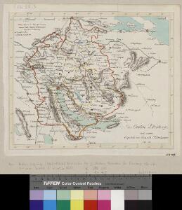
Tigurini sive Tigurinus pagus in Helvetiis
1 : 240000 1 Karte par Sanson chez l'autheur aux galleries du Louvre, [Paris]