Maps of Jura

Carte de Suisse suivant sa nouvelle division en XVIII cantons
1 Karte in 2 Bl. dressé par H. Mallet, Ing. Geographe [Verlag nicht ermittelbar], [Erscheinungsort nicht ermittelbar]
Carte de la Suisse
1 : 400000 1 Karte auf 2 Blättern de R. Leuzinger = Karte der Schweiz : Gewässer & Gebirge / von R. Leuzinger Verlag der Dalp'schen Buchhandlung, Bern
Carte du réseau télégraphique Suisse
1 : 250000 Westblatt Schweizerische Telegraphen- und Telephonverwaltung Kartographische Anstalt LIPS
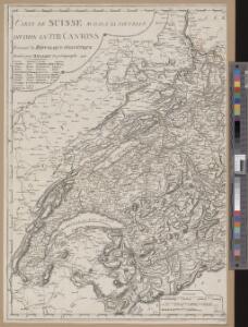
Neue Karte von der Schweiz oder Helvetien in die XIII Eidgenossenschaften, ihre Bundsverwandten und Unterthanen eingetheilt
1 Karte in 2 Bl nach den zuverlässigsten Nachrichten und neuesten astronomischen Beobachtungen, London 1778 bei W. Faden [, neu hrsg. von F.A. Schraembl] Schalbacher, Wien
Atlas novus Reipublicae Helveticae
1 Atlas ([40] Bl., 97 S.) bey Orell, Gessner und Compagnie, Zürich
Carte du réseau téléphonique suisse
1 : 250000 Westblatt Schweizerische Telegraphen- und Telephonverwaltung H. & A. Kümmerly & Frey
Touristen-Karte der Schweiz
1 : 400000 Evropa Imfeld, X. Jura–Simplon-Bahn
Fragment de l'Atlas de la Suisse par Tschudi 1538
Tschudi, Aegidius Hofer & Burger
Karte der Schweiz
Švýcarsko Leuzinger, Rudolf J. Dalp
Carte de Suisse suivant sa nouvelle division en XVIII cantons formant la République Helvétique, 1
1 Blatt : chez F. Monty
Parte occidentale dell'Elvezia divisa ne' suoi cantoni
1 : 600000 1 Karte di nuova projezione / [G. Zuliani inc.] ; [G. Pitteri scri.] presso Antonio Zatta, Venezia
<<Das>> Wiflispurgergow
1 : 500000 1 Karte [von Johannes Stumpf] [Christoph Froschauer oder Johann Wolf], [Zürich]
Mappa Geographica illustris Helvetiorum Republicae Bernensis cum adjacentibus pagorum et dynastiarum confiniis accurate delineata
1 : 460000 Mollova mapová sbírka Seutter, Matthäus Seutter, Albrecht Carl Seutter, Matthäus
Mappa Geographica illustris Helvetiorum Republicae Bernensis cum adjacentibus pagorum et dynastiarum confiniis accurate delineata
1 : 460000 Mollova mapová sbírka Seutter, Matthäus Seutter, Albrecht Carl Seutter, Matthäus
Nouvelle carte géographique de la Suisse
1 : 600000 1 Karte auf 4 Bl. dressé par Jacq. Scheuchzer chez R. & J. Wetstein et Guil. Smith, Amsterdam
Landtaflen
1 Atlas [von Johannes Stumpf] Christoffel Froschower, Zürych
Sabavdiae, et Bvrgvndiae comitatus descriptio
1 Karte : Kupferdruck ; 30 x 21 cm Ortelius; Boileau de Bouillon s.n.
[Keller's Reisekarte der Schweiz]
1 : 500000 1 Karte auf 6 Bl. gezeichnet v. H. Keller ; gest. v. J.J. Scheurmann [Keller], Zürich
Hypsometrische Karte der Schweiz
1 : 380000 1 Karte auf 4 Blättern von J.M. Ziegler = Carte hypsométrique de la Suisse / par J.M. Ziegler Verlag von Joh. Wurster u. Comp., Winterthur
<<Das>> Wiflispurgergow
1 : 500000 1 Karte [von Johannes Stumpf] [Christoph Froschauer oder Johann Wolf], [Zürich]
Eisenbahnkarte der Schweiz
1 : 500000 Topogr. Anstalt v. Wurster, Randegger & Co.
Nova Helvetiae tabula geographica illustrissimis et potentissimis cantonibus et rebuspublicis reformatae religionis Tigurinae, Bernensi, Glaronensi, Basiliensi, Scaphusianae, Abbatis Cellanae
1 : 230000 1 Karte auf 4 Bl. dominis suis clementissimis humillime dicata a Ioh. Iacobo Scheuchzero Tigurino, 1712 ; Ioh. Melch. Füsslin ornamenta pinx. ; Ioh. Henr. Huber et Eman. Schalch sculps. [Hofmeister], [Zürich]
Nova Helvetiae tabula geographica illustrissimis et potentissimis cantonibus et rebuspublicis reformatae religionis Tigurinae, Bernensi, Glaronensi, Basiliensi, Scaphusianae, Abbatis Cellanae
1 : 230000 1 Karte auf 4 Bl. dominis suis clementissimis humillime dicata a Ioh. Iacobo Scheuchzero Tigurino ; Ioh. Melch. Füsslin ornamenta pinx. ; Ioh. Henr. Huber et Eman. Schalch sculps. [Hofmeister], [Zürich]
Carte du phénomène erratique et des anciens glaciers du versant nord des Alpes suisses et de la chaîns du Mont-Blanc
1 : 250000 1 Karte auf 4 Blättern par Alphonse Favre ; publ. par la Commission géologique de la Société Helvétique des Sciences Naturelles [Verlag nicht ermittelbar], [Erscheinungsort nicht ermittelbar]
[Reisekarte der Schweiz]
1 : 500000 1 Karte auf 6 Bl. gezeichnet v. H. Keller ; gest. v. J.J. Scheurmann [Füssli & Comp.], [Zürich]
Reisekarte der Schweiz
1 : 500000 1 Atlas (1, 6 Bl.) gezeichnet von H. Keller und gestochen von J. Scheurmann = Carte routière de la Suisse / dessinée par H. Keller et gravée par J. Scheurmann bey Fuessli und Comp., Zürich
Officielle Eisenbahn-Karte der Schweiz
1 : 250000 4 Karten gest. von H. Müllhaupt Eidg. Stabsbureau, [Bern]
Karte der Schweiz in IV Blättern
1 : 250000 4 Karten nach dem topographischen Atlasse des eidgenössischen Generalstabes reduziert unter der Direction des Herrn Generals G.H. Dufour ; gest. von H. Müllhaupt Eidg. Stabsbureau, [Bern]