Maps of Rüte

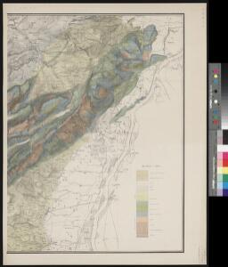
Geologische Karte des Sentis
1 : 25000 1 Karte auf 2 Bl. aufgenommen von Arnold Escher von der Linth in den Jahren 1837-1872 ; hrsg. von der Geologischen Commission der Schweizerischen Naturforschenden Gesellschaft auf Grundlage der Topographischen Karte des Kantons St. Gallen im Massstab 1:25 000 auf Kosten der Eidgenossenschaft 1873 Topogr. Anstalt v. Wurster, Randegger & Cie., Winterthur
Hans Konrad Gyger's Züricher-Cantons-Carte
1 : 32000 Blatt 2 Gyger, Hans Conrad ; Zeller-Werdmüller, Heinrich Hofer & Burger
Wandkarte des Cantons Appenzell
1 : 35700 1 Karte auf 4 Blättern J.M. Müller, B. Tanner 1859 Wurster, Winterthur
Grosse Landtafel des Zürcher Gebiets: Blatt 2: Freiherrschaft Sax-Forstegg: Sax und Umgebung
Möglicherweise: Wagner, Johann (1675-1714)
Hans Konrad Gyger's Züricher-Cantons-Carte 1667
1 : 32000 1 Karte in 56 Teilen Hans Konrad Gyger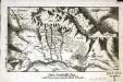
Freÿ=Herrschaft Sax, nebst dem angrenzenden Amt Gambs
1 Vogelschaukarte : Kupferdruck ; 13 x 23 cm s.n.
Rhein-Correction
1 : 25000 4 Karten J. Wurster u. Comp., Winterthur
Sargans SG bis Rheineck SG: Rheinkorrektionen; Grundrisse: Blatt 2: Werdenberg
1 : 25000 Mit Querprofil sowie Kostenvoranschlag nach Gemeinden und Baugegenständen. Joh. Wurster und Comp., in Winterthur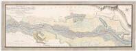
Sennwald SG: An der Herrschaft Sax-Forstegg vorbeifliessender Rhein, insbesondere die Wuhrungen und anstossenden Güter; Grundriss
Handgezeichnete Kopie eines in den Jahren 1769 und 1770 von Joh. Conrad Römer, Ingenieurhauptmann, verfertigten Originalplans. Kopie: Fehr, Johannes, andere Schreibweise: Feer, (1796-1830), Sohn von Johannes Fehr (1763-1823), Ingenieur, von Zürich
Hans Konrad Gyger's Züricher-Cantons-Carte
1 : 32000 Blatt 1 Gyger, Hans Conrad ; Zeller-Werdmüller, Heinrich Hofer & Burger
Rhein-Correction
1 : 25000 Blatt Werdenberg Topographische Anstalt von Joh. Wurster u. Comp. (Winterthur) J. Wurster u. Comp.
Grosse Landtafel des Zürcher Gebiets: Blatt 1: Freiherrschaft Sax-Forstegg: Oberried
Möglicherweise: Wagner, Johann (1675-1714)
Sennwald SG: An der Herrschaft Sax-Forstegg vorbeifliessender Rhein, insbesondere die Wuhrungen und anstossenden Güter; Grundriss
Ohne Datumsangabe.
Pagus helvetiæ Abbatiscellanus
1 Karte : Kupferdruck ; 49 x 56 cm Walser; Seutter; Lotter; Eichler; Probst anjezo in Verlag bey Ioh. Mich. Probst Chalc
Pagus helvetiæ Abbatiscellanus
1 Karte : Kupferdruck ; 49 x 56 cm Walser; Seutter; Lotter; Eichler; Probst anjezo in Verlag bey Ioh. Mich. Probst Chalc
Pagus helvetiæ Abbatiscellanus
1 Karte : Kupferdruck ; 49 x 57 cm Walser; Seutter; Lotter; Eichler Matthäus Seutter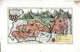
Das Land Appenzell der Innern- u. Aussern-Rooden
1 Karte : Kupferdruck ; 20 x 36 cm Walser s.n.
Topographische Karte des Cantons St. Gallen mit Einschluss des Cantons Appenzell
1 : 25000 16 Karten aufgenommen von J. Eschmann ... [et al.] ; gestochen von P. Steiner ; Gebirg von J. Randegger ; Gebirgszeichnung u. Leitung des Stiches durch J.M. Ziegler Topographische Anstalt v. Joh. Wurster & Comp., Winterthur
Hans Konrad Gyger's Züricher-Cantons-Carte 1667
1 : 32000 1 Karte in 56 Teilen Hans Konrad Gyger
Topographische Karte des Kantons St. Gallen mit Einschluss des Kantons Appenzell (Eschmann-Karte): Blatt Werdenberg
1 : 25000 Aufnahme: Eschmann, Johannes (1808-1852), Geodät und Mathematiker, von Zürich; Merz, Johann Ludwig, andere Schreibweise: Mertz, (1772-1851), Kaufmann und Oberstleutnant, von Herisau AR; Merz, Ludwig, andere Schreibweise: Mertz, (1817-1881), Kaufmann, von Herisau AR Stich: Steiner, P.; Leuzinger, Rudolf (1826-1896), Kartograf und Lithograf, von Netstal GL und Mollis GL Gebirgszeichnung und Leitung des Stichs: Ziegler, Jakob Melchior (1801-1883), Kartograf Stich und Druck: Joh. Wurster und Comp., in Winterthur
Topographische Karte des Kantons St. Gallen mit Einschluss des Kantons Appenzell (Eschmann-Karte): Blatt Altstätten - Appenzell
1 : 25000 Aufnahme: Eberle, Joseph Meinrad (1809-1896), Ingenieur; Merz, Johann Ludwig, andere Schreibweise: Mertz, (1772-1851), Kaufmann und Oberstleutnant, von Herisau AR; Merz, Ludwig, andere Schreibweise: Mertz, (1817-1881), Kaufmann, von Herisau AR Stich: Steiner, P.; Leuzinger, Rudolf (1826-1896), Kartograf und Lithograf, von Netstal GL und Mollis GL; Randegger, Johannes (1830-1900), Kartograf Gebirgszeichnung und Leitung des Stichs: Ziegler, Jakob Melchior (1801-1883), Kartograf Stich und Druck: Joh. Wurster und Comp., in Winterthur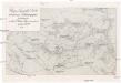
Weg- u. Touristen Karte vom Fürstentum Liechtenstein
Lichtenštejnsko Sektion Liechtenstein des D. u. Ö. A. V.
Topographische Karte des Cantons St. Gallen mit Einschluss des Cantons Appenzell
1 : 25000 Blatt 13 Eschmann, Johannes ; Steiner, P. ; Randegger, Johannes ; Ziegler, Jakob Melchior Topographische Anstalt v. Joh. Wurster & Comp.
Topographische Karte des Cantons St. Gallen mit Einschluss des Cantons Appenzell
1 : 25000 Blatt 7 Eschmann, Johannes ; Steiner, P. ; Randegger, Johannes ; Ziegler, Jakob Melchior Topographische Anstalt v. Joh. Wurster & Comp.
Topographische Karte des Cantons St. Gallen mit Einschluss des Cantons Appenzell
1 : 25000 16 Karten aufgenommen von J. Eschmann ... [et al.] ; gestochen von P. Steiner ; Gebirg von J. Randegger ; Gebirgszeichnung u. Leitung des Stiches durch J.M. Ziegler Topographische Anstalt v. Joh. Wurster & Comp., Winterthur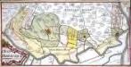
Das Rheinthal
1 Manuskriptkarte : 24 x 48 cm Bernigeroth s.n.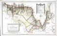
Specialcharte des Rheinthals
1 Karte : Kupferdruck ; 40 x 65 cm Feer; Lips; Custer s.n.
Topographische Karte des Kantons St. Gallen mit Einschluss des Kantons Appenzell (Eschmann-Karte): Blatt Oberriet
1 : 25000 Aufnahme: Eberle, Joseph Meinrad (1809-1896), Ingenieur Stich: Steiner, P.; Leuzinger, Rudolf (1826-1896), Kartograf und Lithograf, von Netstal GL und Mollis GL Gebirgszeichnung und Leitung des Stichs: Ziegler, Jakob Melchior (1801-1883), Kartograf Stich und Druck: Joh. Wurster und Comp., in Winterthur