Maps of Valais/Wallis

Schulwandkarte zur Geschichte der Schweiz
1 : 180000 1 Karte auf 6 Bl. bearbeitet v. W. Oechsli u. A. Baldamus ; gezeichnet von Ed. Gaebler Kartograph. Verlagsanstalt von Georg Lang, Leipzig
[Keller's Reisekarte der Schweiz]
1 : 500000 1 Karte auf 6 Bl. gezeichnet v. H. Keller ; gest. v. J.J. Scheurmann [Keller], Zürich
Reisekarte der Schweiz
1 : 500000 1 Atlas (1, 6 Bl.) gezeichnet von H. Keller und gestochen von J. Scheurmann = Carte routière de la Suisse / dessinée par H. Keller et gravée par J. Scheurmann bey Fuessli und Comp., Zürich
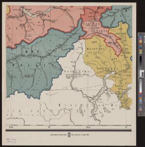
Schulwandkarte zur Geschichte der Schweiz
1 : 180000 Südblatt Oechsli, Wilhelm ; Baldamus, Alfred Kartograph. Verlagsanstalt von Georg Lang
Geologische Kartenskizze der Alpen zwischen St. Gotthard & Montblanc
1 : 350000 Alpy (pohoří) Schmidt, Carl Ernst Finckh
Raetiae veteris et exterae pars occidentalis qua Lepontii (gens perantiqua Cis ac Transalpina) continentur
1 : 550000 1 Karte [Matthias Hirtzgartner] [Joh. Rodolff Wolffen], [Zürich]
Original von Keller's zweiter Reisekarte der Schweiz
1 : 500000 1 Karte in 4 Teilen gest. v. J. Scheurmann Keller, Zürich
Atlas novus Reipublicae Helveticae
1 Atlas ([40] Bl., 97 S.) bey Orell, Gessner und Compagnie, Zürich
Atlas de la Suisse
1 : 450000 1 Atlas (19 Bl.) dessiné par MM. H. Keller, Scheurmann, Pfyffer d'Altishofen, Osterwald, etc. ; gravé par M. Scheurmann Orell Füssli & Co., Zürich
<<Die>> Lepontier
1 : 470000 1 Karte [Johannes Stumpf] [Froschauer], [Zürich]
Atlas der Schweiz
1 : 450000 1 Atlas (18 Bl.) gez. u. gest. v. J. Scheurmann Orell Fussli, Zurich
Locarno
1 : 200000 1 Karte entworfen und bearbeitet von Woerl ; in Stein gestochen unter seiner Leitung 1835 ; Lithographie von B. Herder Herder, Freiburg im Breisgau
Biella
1 : 200000 1 Karte entworfen und bearbeitet von Woerl ; in Stein gestochen unter seiner Leitung 1835 ; Lithographie von B. Herder Herder, Freiburg im Breisgau

Taschen-Atlas der Schweiz
1 Atlas (25 S., 20 Taf.) gezeichnet und gestochen von Emil Wagner = Atlas de poche de la Suisse : 26 cartes en couleurs / dessinées et gravées par Émile Wagner Eggimann, Genf
Wandkarte der Schweiz
1 : 200000 1 Karte auf 8 Blättern J.M. Ziegler Wurster, Winterthur
<<Der>> Canton Wallis
1 : 450000 1 Karte gez. u. gest. v. J. Scheuermann Orell Füssli & Comp., Zürich
<<Der>> Canton Wallis
1 : 450000 1 Karte gez. u. gest. v. J. Scheuermann Orell Füssli & Comp., Zürich
Landtaflen
1 Atlas [von Johannes Stumpf] Christoffel Froschower, Zürych
Parte Alpestre Dello Stato Di Milano, Con il Lago Maggiore Di Lugano, É Di Como [Karte], in: Le théâtre du monde, ou, Nouvel atlas contenant les chartes et descriptions de tous les païs de la terre, Bd. 3, S. 63.
1 Karte aus Atlas Blaeu, Willem Janszoon und Blaeu, Joan Blaeu, Willem Janszoon
Carte de la Ligne du Simplon
1 : 450000 Švýcarsko Geogr. Anstalt Kümmerly & Frey
<<Der>> Canton Wallis
1 : 450000 1 Karte gez. u. gest. v. J. Scheuermann Orell Füssli & Comp., Zürich
[Wallis]
1 : 500000 1 Karte [Johannes Stumpf] [Christoffel Froschouer], [Zürych]
Parte Alpestre Dello Stato Di Milano, Con il Lago Maggiore Di Lugano, È Di Como [Karte], in: Novus Atlas, das ist, Weltbeschreibung, Bd. 3, S. 73.
1 Karte aus Atlas Blaeu, Joan Blaeu, Willem Janszoon
Parte Alpestre Dello Stato Di Milano, Con il Lago Maggiore Di Lugano, É Di Como [Karte], in: Theatrum orbis terrarum, sive, Atlas novus, Bd. 3, S. 61.
1 Karte aus Atlas Blaeu, Joan Blaeu, Willem Janszoon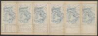
Valesiae Prior Et VI. Nova Tabula. [Karte], in: Claud. Ptolemaeus. Geographia lat. cum mappis [...], S. 353.
1 Karte aus Atlas Münster, Sebastian [und Ptolemaeus, Claudius]
Carte de la Suisse avec les plans des cheflieux des 22 cantons
1 : 200000 1 Karte auf 8 Bl. dessinée et publié par Henri Keller ; Lithogr. von J. Schweizer = Charte der Schweiz mit den Grundrissen der Hauptorte der 22 Cantone Keller, Zürich
Ticino
1 : 1450000 [Stumme Kartenskizzen der ganzen Schweiz und der einzelnen Kantone zu Unterrichtszwecken] Schulbuchhandlung Antenen
Carte de la Suisse avec les plans des cheflieux des 22 cantons
1 : 200000 1 Karte auf 8 Bl. dessinée et publié par Henri Keller ; Lithogr. von J. Schweizer = Charte der Schweiz mit den Grundrissen der Hauptorte der 22 Cantone Keller, Zürich