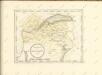
Maps of Upper Savoy

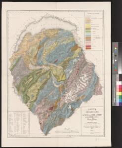
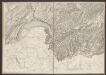
Carte géologique des parties de la Savoie, du Piémont et de la Suisse voisines du Mont Blanc
1 : 150000 1 Karte par Alphonse Favre Etablissement topographique de J. Wurster et Cie., Winterthur
[Keller's Reisekarte der Schweiz]
1 : 500000 1 Karte auf 6 Bl. gezeichnet v. H. Keller ; gest. v. J.J. Scheurmann [Keller], Zürich
[Schweiz]
1 : 390000 Südwest-Blatt Ziegler, Jakob Melchior [s.n.]
Schulwandkarte zur Geschichte der Schweiz
1 : 180000 1 Karte auf 6 Bl. bearbeitet v. W. Oechsli u. A. Baldamus ; gezeichnet von Ed. Gaebler Kartograph. Verlagsanstalt von Georg Lang, Leipzig
Schweiz
1 : 390000 Südwest-Blatt [s.n.]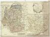
Karte von dem Herzogthume Savoyen und den Grafschaften Nizza, Tenda und Borgio, oder den Ländern welche der König von Sardinien in dem Frieden zu Paris den 15. May 1796 der französischen Republik abtrat
1 : 570000 Nice (Francie)
Wandkarte der Schweiz
1 : 200000 1 Karte auf 8 Blättern J.M. Ziegler Wurster, Winterthur
Duché de Savoye qui comprend le Chablais, le Fossigny, le Génovois, le Savoye propre, la Tarentaise et la Maurienne
1 : 350000 Savojsko Robert de Vaugondy, Gilles Borgonio, Giovanni Tommaso C. F. Delamarche
Sabavdia dvcatvs
1 Karte : Kupferdruck ; 26 x 34 cm Merian
Sabaudia ducatus
1 : 440000 Savojsko Hondius, Jodocus Judocus Hondius
Tabvla generalis Sabavdiæ
1 Karte : Kupferdruck ; 49 x 58 cm Blaeu; Borgonio; Broen Ottens ...hos
Tabvla generalis Sabavdiæ
1 Karte : Kupferdruck ; 49 x 58 cm Blaeu; Borgonio; Broen Joannes Blaeu excudit
Schulwandkarte zur Geschichte der Schweiz
1 : 180000 Südwest-Blatt Oechsli, Wilhelm ; Baldamus, Alfred Kartograph. Verlagsanstalt von Georg Lang
Duche de Savoye.
1 : 325000 Robert de Vaugondy, Gilles, 1688-1766
Sabavdia dvcatvs
1 Karte : Kupferdruck ; 36 x 48 cm Janssonius apud Joan: Janssonium
Sabavdia dvcatvs
1 Karte : Kupferdruck ; 36 x 47 cm Valck; Schenk apud G. Valk et P. Schenk
Sabavdia dvcatvs
1 Karte : Kupferdruck ; 36 x 47 cm Blaeu apud Guiljelmum Blaeuw
Sabaudia ducatus
1 Karte : Kupferdruck ; 17 x 24 cm Mercator Cloppenburgh
Sabaudia ducatus
1 Karte : Kupferdruck ; 35 x 48 cm Hondius; Goos Judocus Hondius excudit
La Savoye
1 Karte : Kupferdruck ; 38 x 29 cm, Bildgrösse 40 x 54 cm Duval chez l'autheur en l'Isle du palais sur le quay de l'Orloge proche le coin de la ruë de Harlay
Carte géologique des parties de la Savoie, du Piémont et de la Suisse voisines du Mont Blanc
1 : 150000 Favre, Alphonse Etablissement topographique de J. Wurster et Cie.
Statvvm Italiae Svperioris vulgo olim Lombardia
1 : 320000 Mollova mapová sbírka Mayer, Tobias Homann, Johann Baptista - dědici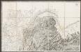
[Hochsavoyen]
1 : 250000 Lecocq, A. [Stato Maggiore]
Les duchez de Savoye, de Chablais, et de Genevois, les comtez de Maurienne, et de Tarantaise, et la baronie de Fausigny
1 Karte : Kupferdruck ; 52 x 41 cm Fer chez le Sr. de Fer geographe de Sa Majesté catholique et de Monseigneur le dauphin dans l'Isle du palais sur le quay de l'Orloge a la sphere royale
Département du Mont Blanc
1 : 260000 Mont Blanc (Francie a Itálie) Houdan, François d' P. G. Chanlaire
Officielle Eisenbahn-Karte der Schweiz
1 : 250000 Südwest-Blatt Müllhaupt, Hans Heinrich [Eidg. Stabsbureau]
Distanzenkarte von der Schweiz
1 : 200000 1 Karte in 8 Teilen nach den besten Hülfsquellen bearb. von R. Huber Wagner, Bern