Maps of Schaffhausen

Hans Konrad Gyger's Züricher-Cantons-Carte 1667
1 : 32000 1 Karte in 56 Teilen Hans Konrad Gyger
Laufen-Uhwiesen bis Ensisheim (Frankreich): Projektierte Schifffahrtsverbindung Ill-Rhein-Bodensee-Donau; Situationspläne: Projektierte Rhein-Kanalanlage mit Schleusen und Turbinenanlagen bei Dachsen und Laufen-Uhwiesen zur Umgehung des Rheinfalls; Längsprofil der Schleusen und Situationsplan
1 : 25000 Mit Legende. Nico, Eugène
Gemeinde Jestetten (Deutschland) und Gemeinde Lottstetten (Deutschland): Bann; Grundriss
Meyer, Johann Michael, Geometer, von Stühlingen (Deutschland)
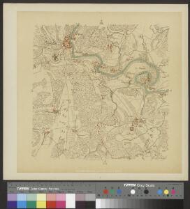
Grosse Landtafel des Zürcher Gebiets: Blatt 26: Schaffhausen und Umgebung
Möglicherweise: Wagner, Johann (1675-1714)
Rheinau
1 : 25000 1 Karte [Lithographie: Johann Jakob Brack]
Hans Konrad Gyger's Züricher-Cantons-Carte
1 : 32000 Blatt 26 Gyger, Hans Conrad ; Zeller-Werdmüller, Heinrich Hofer & Burger
Grenze zwischen dem Zürcher und dem Schaffhauser Gebiet entlang des Rheins von Schaffhausen bis Rheinau; Übersichtskarte
Handgezeichnete Kopie des von Hans Conrad Gyger, andere Schreibweisen: Geiger, Geyger, (1599-1674), Kartograf, Ingenieur und Amtmann des Amts Kappelerhof, von Zürich, verfertigten Originalplans. Esslinger, Johann Rudolf
Meßtischblatt (8317) : Jestetten, 1879
1 : 250000 Jestetten. - 1:25000. - Leipzig: Giesecke & Devrient, 1879. - 1 Kt.
Meßtischblatt [8217] : Wiechs, 1880
1 : 250000 Wiechs. - [Ausg.] 1879 u. 1880. - 1:25000. - Leipzig: Giesecke & Devrient, 1880. - 1 Kt.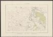
Rheinau
1 : 25000 Brack, Johann Jakob [Topographisches Bureau]
Feuerthalen, Flurlingen, Laufen-Uhwiesen, Dachsen, Neuhausen am Rheinfall SH und Schaffhausen: Abwasseranfall und Abwasserreinigung; Übersichtskarte
1 : 10000 Mit Angabe bestehender und projektierter Anlagen und deren Einzugsgebiet.
Topographischer Atlas der Schweiz (Siegfried-Karte): Den Kanton Zürich betreffende Blätter: Blatt 25: Rheinau
1 : 25000 Erstausgabe 1883. Leitung: Siegfried, Hermann (1819-1879), Topograf und Kartograf, von Zofingen AG; Eidgenössisches Topographisches Bureau, in Bern Aufnahme: Denzler, Hans Heinrich (1814-1876), Ingenieur, von Eglisau und Uster; Wetli, Kaspar, andere Schreibweise: Wethli, (1822-1889), Ingenieur, von Männedorf; Badisches topographisches Bureau Revision: Benz, J. Stich: Falquet, Louis (1854-1939); Smith, L.
Topographischer Atlas der Schweiz (Siegfried-Karte): Den Kanton Zürich betreffende Blätter: Blatt 16: Schaffhausen (ohne deutsches Gebiet)
1 : 25000 Erstausgabe 1880. Leitung: Siegfried, Hermann (1819-1879), Topograf und Kartograf, von Zofingen AG; Eidgenössisches Topographisches Bureau, in Bern Aufnahme: Auer, Conrad Martin Carl (1839-1898); Wetli, Kaspar, andere Schreibweise: Wethli, (1822-1889), Ingenieur, von Männedorf Revision: Benz, J. Stich: Müllhaupt, Heinrich (1820-1894), Kupferstecher und Kartograf, von Hofstetten; Müllhaupt, Fritz (1846-1917), von Hofstetten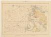
Kanton Zürich: Waldungen, Rebberge und Rodungen um die Mitte des 17. Jahrhunderts: Blatt II: Rheinau
1 : 25000 Ohne Erstellungsdatumsangabe. Ausgangskarte: Blatt II (Rheinau) der Topographischen Karte des Kantons Zürich (Wild-Karte). Tirkanits, Miklos, andere Schreibweise: Nikolaus, (geb. 1923), Ingenieur und Assistent für Kartografie an der Eidgenössischen Technischen Hochschule Zürich, von Ungarn Ausgangskarte Leitung: Wild, Johannes (1814-1894), Ingenieur sowie Strassen- und Wasserbauinspektor des Kantons Zürich, von Richterswil Ausgangskarte Zeichnung: Enderli, Heinrich (1830-1902), Zeichner, von Wipkingen Ausgangskarte Stich: Brack, Johann Jakob (1824-1867), Lithograf, von Neunforn TG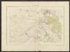
Rheinau
1 : 25000 Karte des Kantons Zürich im Masstab von 1:25 000, Blatt 2 Wild, Johannes Topographisches Bureau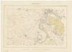
Topographische Karte des Kantons Zürich (Wild-Karte): Blatt II: Rheinau
1 : 25000 Leitung: Wild, Johannes (1814-1894), Ingenieur sowie Strassen- und Wasserbauinspektor des Kantons Zürich, von Richterswil Zeichnung: Enderli, Heinrich (1830-1902), Zeichner, von Wipkingen Stich: Brack, Johann Jakob (1824-1867), Lithograf, von Neunforn TG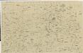
Vorlagen für die Topographische Karte des Kantons Zürich (Wild-Karte): Schrift-Pausen: Blatt II: Rheinau
1 : 25000
Original-Messtischaufnahmen für die Topographische Karte des Kantons Zürich (Wild-Karte): Blatt 19: Rheinau
1 : 25000 Wetli, Kaspar, andere Schreibweise: Wethli, (1822-1889), Ingenieur, von Männedorf
Vorlagen für die Topographische Karte des Kantons Zürich (Wild-Karte): Pausen mit Gemeindegrenzen: Blatt 19: Marthalen und umliegende Gemeinden
1 : 25000
Karte über die Umgebung von Schaffhausen mit den prähistorischen Stationen zum Schweizersbild und Kesslerloch
1 : 25000 1 Karte Topogr. Anstalt Winterthur J. Schlumpf [Zürcher & Furrer], [Zürich]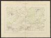
Flaach
1 : 25000 Karte des Kantons Zürich im Masstab von 1:25 000, Blatt 6 Wild, Johannes Topographisches Bureau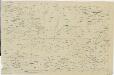
Vorlagen für die Topographische Karte des Kantons Zürich (Wild-Karte): Schrift-Pausen: Blatt VI: Flaach
1 : 25000
Rheinau: Definition der Siedlungen für die eidgenössische Volkszählung am 01.12.1950; Siedlungskarte
1 : 10000 Auf Ausgangskarte angebrachte farbige Einzeichnungen und Eintragungen. Ohne Erstellungsdatumsangabe.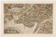
Kloster Rheinau: Waldungen; Grundriss

Grosse Landtafel des Zürcher Gebiets: Blatt 25: Hemmental und Umgebung
Möglicherweise: Wagner, Johann (1675-1714)
Marthalen: Definition der Siedlungen für die eidgenössische Volkszählung am 01.12.1950; Siedlungskarte
1 : 10000 Auf Ausgangskarte angebrachte farbige Einzeichnungen und Eintragungen. Ohne Erstellungsdatumsangabe.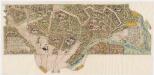
Kloster Rheinau: Waldungen in Marthalen; Grundriss

Marthalen: Gemeinde; Übersichtsplan (Schweizerische Grundbuchvermessung)
1 : 5000
Marthalen: Definition der Siedlungen für die eidgenössische Volkszählung am 01.12.1970; Siedlungskarte
1 : 5000 Auf Ausgangskarte angebrachte farbige Einzeichnungen und Eintragungen. Mit Legende. Ohne Erstellungsdatumsangabe.