Maps of Regierungsbezirk Freiburg

Die in und um Schwaben gelegenen Östreichischen Antheile in der ämtlichen Sprache Vorderöstreich : Nro. 150
Reilly, Franz Johann Joseph von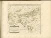
Die in und um Schwaben gelegenen Östreichischen Antheile in der ämtlichen Sprache Vorderöstreich : Nro. 58
Reilly, Franz Johann Joseph von
Teutzchlandes Schwaebischer Creiss samt dazugehörigen Provintzen
1 : 1900000 Mollova mapová sbírka Weigel, Christoph Weigel, Christoph I.
Circvli Sveviae Mappa
1 : 470000 Mollova mapová sbírka Hase, Johann Matthias Homann, Johann Baptista - dědici
Circvli Sveviae Mappa
Hase, Johann Matthias Homann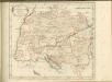

Circuli Sveviae
1 : 477000 Švábsko (Německo) Hase, Johann Matthias Homan[n]ianorum Heredum
Circvlvs Svevicvs
1 : 780000 Mollova mapová sbírka Weigel, Christoph Kauffer, Michael Weigel, Christoph I.
Deß Hayligen Römischen Reichs Schwebischen Kraysssampt seinen Vmb unnd Inligenden lannd vnnd Herrschafften
1 : 790000 Mollova mapová sbírka Mannasser, Daniel Mittnacht, Moritz
Charte von Schwaben
1 Karte : Kupferdruck ; 44 x 50 cm im Verlage des Geograph. Instituts
Cercle De Souabe, dans lequel sont distingués les principaux Etats, et les Enclaves De La Maison D'Autriche
Robert de Vaugondy, Didier Remondini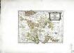
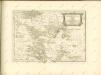
Die Landgrafschaft Nellenburg die Landvogtey Altorf
1 Karte : Kupferdruck ; 19 x 27 cm Reilly F. J. J. von Reilly
Charte von Schwaben
1 : 390000 Švábsko (Německo) Amman, Ignaz Ambros von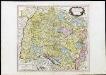
Cercle De Souabe dans lequel sont distingués les principaux Etats, et les Enclaves De La Maison D'Autriche
Robert de Vaugondy, Didier Remondini
Circulus siue Liga Sveviae Vulgo Schwabische Kraiß
1 : 950000 Mollova mapová sbírka Seltzlin, David Plantin, Christoph
Cercle de Souabe, dans lequel sont distingués les principaux etats, et les enclaves de la maison d'Autriche
1 Karte : Kupferdruck ; 46 x 50 cm Robert de Vaugondy; Remondini; Santini chez Mr. Remondini
Cercle de Souabe dans lequel sont distingués les principaux etats, et les enclaves de la maison d'Autriche
1 Karte : Kupferdruck ; 47 x 51 cm Robert de Vaugondy G. et D. Robert de Vaugondy
Nigra Sylva XI. Nova Tabula. [Karte], in: Claud. Ptolemaeus. Geographia lat. cum mappis [...], S. 374.
1 Karte aus Atlas Münster, Sebastian [und Ptolemaeus, Claudius]
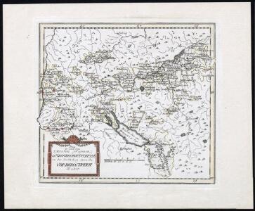
Der schwæbische Kreis. nebst den österreichischen Besizungen in Schwaben
1 Karte : Kupferdruck ; 46 x 51 cm im Verlage des Industrie-Comptoirs
Vollständige Carte des gantzen Rhein Stroms]
1 : 840000 Mollova mapová sbírka Riegel, Christoph Riegel, Christoph
Straßen im Königreich Württemberg 1848
Württemberg Straßennetz Kunz, Andreas ; Treiling, Thomas
Imp. Caes. Carolo VI. Avgvsto Pio Victori gentis svae sideri felicissimo chorographiam hanc exhibentem primar. Regionvm Habspvrgicar sitvm positvmq brevibvs exterarvm ditionvm intervallis vt permistvm nec non vltimos Imperii Germ. Terminos perpetva transitvvm obsidionvm Hibernorvm Coactionvm vexatione agitatos antiqvae fidei et invictae testes pietatis svpplex dicat Provincia Brisgoia Avst. Ant. MDCCXVIII. Cum Privilegio Sac. Caes. Majestatis
1 : 241000 Mollova mapová sbírka Homann, Johann Baptist Homann, Johann Baptista
Accurata Delineatio Brisgoviae cum Civitatibus Silvestribus Austriae Anterioris, tanquam Limitum et Terminorum Imperii Rom. Germanici versus Occasum cura et impensis
1 : 242000 Mollova mapová sbírka Seutter, Matthäus Seutter, Matthäus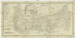
Commercial Charte
1 : 290000 Horní Rakousko (Rakousko) Eberle Walz
Sect. 26: Augsburg, uit: Geologische Karte des Deutschen Reichs in 27 Blaettern / [von] Richard Lepsius ; Red. von C. Vogel
1 : 500000 Annotatie: Blad 18 ontbreekt; Een aantal bladen op linnen; Een aantal bladen gereviseerd 1913-1914; Annotatie geografische gegevens: Met schaalstokken o.a. in kilometers; Legenda Carl Vogel 1828-1897 Gotha : Justus Perthes
Totius s.r.i. circuli Suevici tabula chorographica, 3
1 Blatt : R. et J. Ottens
Nova Alemanniæ sive Sveviæ svperioris tabvla
1 Karte : Kupferdruck ; 36 x 47 cm Valck; Schenk apud G. Valk et P. Schenk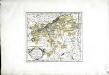
Die Markgrafschaft Burgau mit den Grafschaften Kirchberg und Weissenhorn
1 Karte : Kupferdruck ; 21 x 23 cm Reilly F. J. J. von Reilly