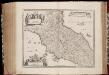
Maps of Tuscany
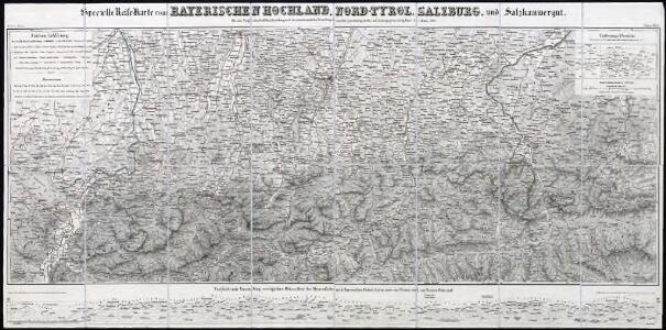
Specielle Reise-Karte vom Bayerischen Hochland, Nord-Tyrol, Salzburg, und Salzkammergut : mit einer Vergleichenden Höhendarstellung nach den neuesten amtlichen Vermessungen
1 : 500000 Mayr, [Johann] Georg Mayr
Carte itinéraire indiquant la marche des armées Françaises en Allemagne et en Italie : faisant suite à la carte en 8 feuilles de L. Capitaine ... / par P.C. Chanlaire
1 : 850000 Annotatie: Overige bl. niet aanwezig Chanlaire, P. C Paris : Dépot de Géographie
Italy. North Part.
1 : 2500000 Mitchell, Samuel Augustus
Italy. North Part.
1 : 2450000 Tanner, Henry S.
Italy North Part.
1 : 2450000 Tanner, Henry S.
Flemming's neueste Karte des Kriegsschauplatzes in Italien
1 : 618000 Itálie severní C. Flemming
Die Staaten von Ober Italien
Itálie severní Stanich, Eugen Rothenburg, R. von Verlag der geographischen Anstalt des Bibliographischen Instituts
Italy middle, upper.
1 : 1100000 Robert Laurie & James Whittle
Northern Italy.
1 : 3168000 Tallis, J. & F.
Le royaume de France, 6
1 Blatt : 48 x 46 cm Jaillot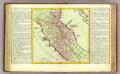
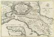
Etat de l'Eglise.
1 : 1500000 Clouet, J. B. L. (Jean-Baptiste Louis), b. 1730
Status Ecclesiasticus et magnus ducatus Thoscanae
1 : 800000 per Fredericum de Wit [Amsterdam] : [Frederick de Wit]

Die Staaten von Oberitalien

Northern Italy.
1 : 1270000 Mitchell, Samuel Augustus
Northern Italy.
1 : 1270000 Mitchell, Samuel Augustus
Italy, North Part.
1 : 2500000 Tanner, Henry S.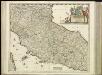
[31][31] Status Ecclesiasticus et Magnus Ducatus Thoscanae, uit: Atlas sive Descriptio terrarum orbis
Annotatie: Gedigitaliseerde versie. Amsterdam. Heiloo : Picturae (vervaardiger), 2015. tiff-bestand. Gedigitaliseerd: 07-01-2015; Origineel: Universiteitsbibliotheek Vrije Universiteit (XL.05127.-) ; Netherlands; Titelpagina ontbreekt Wit, Frederik de Amsterdam : Frederick de Wit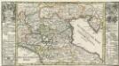
Die Niedere oder Oostliche Lombardia.
1 : 2900000 Mollova mapová sbírka Bodenehr, Gabriel Bodenehr, Gabriel
Tableau l'historie des Duches de Toscane, Parma, Modene, Lucques, et du Royme. Lombard-Venetien.
1 : 3100000 Duval, Henri
X, uit: General-Karte von Mittel-Europa in 12 Blättern, im Masse 1:1.200.000 / entworfen, bearb. und hrsg. von Josef Schlacher
1 : 1200000 Annotatie: Blad 6 ontbreekt; Annotatie geografische gegevens: 21 maatstokken op blad 9; Legenda op blad 9 Wien : K.K. Militär Geografisches Institut

Status Ecclesiae et Magni Ducatus Hetruriae
Reyse-Cart von Italien :
1 : 3000000 Mollova mapová sbírka Bodenehr, Gabriel Bodenehr, Gabriel
Stato Della Chiesa Con La Toscana [Karte], in: Novus atlas absolutissimus, Bd. 5, S. 142.
1 Karte aus Atlas Janssonius Offizin
Stato Della Chiesa, Con La Toscana. [Karte], in: Theatrum orbis terrarum, sive, Atlas novus, Bd. 3, S. 137.
1 Karte aus Atlas Blaeu, Joan Blaeu, Willem Janszoon
Stato Della Chiesa. Dominium Ecclesiasticum In Italia. [Karte], in: Gerardi Mercatoris et I. Hondii Newer Atlas, oder, Grosses Weltbuch, Bd. 2, S. 299.
1 Karte aus Atlas Mercator, Gerhard und Hondius, Jodocus Jansson, Jan
Tabula Itineraria Vienna Austriae Metropoli ad Orbis Urbem Romam
Mollova mapová sbírka Lidl, Johann Jakob Lidl, Johann Jacob
Uibersichts-Carte der Staaten Toscana, Modena u. Parma mit ihrer neuen Gränzbestim[m]ung
Modena (Itálie)