Maps of 's-Hertogenbosch

Nouvelle Carte | representant la Ville de BOLDVC en plan, | avec ses Rempars, Fossez, Forteresses d'alentour etc. | Ensemble Les APPROCHES de chaque Quartier de ceux | de dehors jusques a la dite Ville : [fortification plan]
tout Mesuré et Deßigné, | Par le Sr. Jaques Prempart, Gentilhomme Francois, | Ingenieur du Roy de Swede. Amsterodami, Iohannes Blaeu Excudit.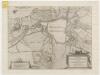
Nouvelle carte representant la ville de Bolduc en plan, avec ses rempars, fossez, forteresses d'alentour etc. ensemble les approches de chaq. quartier de ceux de dehors jusques a la dite ville
1 : 8575 tout mesuré et dessigné par le Sr. Jacques Prempart, Ingenieur du Roy de Swede
Grondtekening der stad 's Hertogenbosch.
1 : 15080 [Amsterdam] : [Tirion]
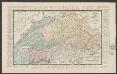
Sylva Ducis, Gallis Bois le Duc, German sHartogenbos.
1 : 4100 t' Amsterdam : by I. Cóvens en C. Mortier
SYLVA DVCIS, | Gallis vulgo | BOIS LE DUC; | Vernacule | 'S HARTOGEN BOSSCHE.
[Amsterdam : Joan Blaeu]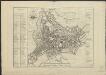
Platte grond der stad 's Hertogenbosch
1 : 5000 J.B. Drossaers fecit Dl. Veelwaard Junior sculps.t. te 's Hertogenbosch : by H. Palier en Zoon
Beleegeringe vande stadt Hertogenbosch anno 1629.
1 : 28000 [Amsterdam] : [Jodocus Janssonius]
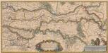
Belegheringhe van 'sHertogenbossche door Syn Excellentie den Prince van Orangien anno 1629
1 : 40000
OBSIDIO ET EXPVGNATIO SYLVÆDVCIS | Auspiciis Ordinum Belgicæ Foederatæ Ductu Illust.mi et invict.mi Principis | FREDERICI HENRICI Arausionensium Principis etc. M DCXXIX.
[Amsterdam : Joan Blaeu]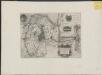
Wahre und eigentliche delineatio der trefflichen undt weitberhümten belägerung der vesten statt Hertzogenbusch, alles nach seiner rechten Mass abgetheilt
1 : 35000 durch Iacobb Prempart Ingenieur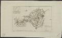
Caart figuratief vande Baronie van Boxtel en Heerlykheyt Liempde, met de steenweg van de Stadt s'Hertogenbosch tot Best ...
1 : 80200 met groote moeytens en costen te samen gesteld door Hendrik Verhees, geadmitteerd landmeeter tot Boxtel J. Hulk fec. [S.l.] : [s.n.]
Beleegeringe vande stadt Hertogenbosch anno 1629
1 : 28000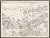
III, uit: Kaart der provincie Noord-Braband : volgens de opmetingen van het kadaster / vervaardigd onder leiding van L. van der Voordt Pieck en M. Kuijl ; getek. door A.B. van Lieshout ; op steen gegrav. door F. Desterbecq ; berekend met betrekking tot de driehoeksmeting door P.E. Fritsen en J. Kuijpers
1 : 50000 titelvariant: Kaart van Noord-Braband; Annotatie: Omslagtitel: Kaart van Noord-Braband; Met opdracht aan de Staten van Noord-Brabant L. van der Voordt Pieck; M. Kuijl; A.B. van Lieshout; François Desterbecq 1807-1896; Fritsen, P.E.; Kuijpers, J. [S.l. : s.n.]
45 's Hertogenbosch, uit: Topographische en militaire kaart van het Koningrijk der Nederlanden / vervaardigd door de officieren van den Generale Staf ; en gegraveerd op het Topographisch Bureau, van het Ministerie van Oorlog
1 : 50000 titelvariant: TMK; Annotatie: Met bladwijzer op schaal 1:600.000. - 1915; Met Verklaring van de topographische en militaire kaart van het Koninkrijk der Nederlanden. - 1910; Bd. 1: titelblad, bladwijzer, verklaring, bladen 1 t/m 32; Bd. 2: bladen 33 t/m 62 Generale Staf, Nederland; Ministerie van Oorlog. Topographisch Bureau ['s-Gravenhage : Ministerie van Oorlog]
Bl. 25 's-Hertogenbosch, 1904, uit: Atlas A.N.W.B.
1 : 200000 titelvariant: Atlas van Nederland van den A.N.W.B. Toeristenbond voor Nederland; Wielrijders-atlas van Nederland; Annotatie: Titel op bladwijzer: Atlas van Nederland van den A.N.W.B. Toeristenbond voor Nederland; Titel op legendablad: Wielrijders-atlas van Nederland; Voor aanwezige bladen zie overzichtsblad; Annotatie geografische gegevens: De serie bestaat uit 36 bladen ANWB ['s-Gravenhage : A.N.W.B.]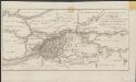
Kaart, behoorende tot de grondbeginselen van het ontwerp der Nieuwe Merwede en de bedijking van de Oude Merwede en den Biesbosch of het Bergsche Veld in 1818

Carte de la Hollande où son [!] les environs de Schoonhove, de Uyane [= Vianen], de Gorcum, d'Heusden, de Geertruydenberg, partie d'Utrecht, et de la Gueldre
1 : 300000 [Guillaume Delahaye] [Paris] : par le sr. Robert géographe ordinaire du roi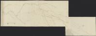
Kaart van de Steenwegh tot aen de Luijkse grensen met allignamenten, tot de vier nieuwe projecte, geteekent in 't jaer 1784.
[S.l.] : [s.n.]
18me Bois le Duc, uit: Nouvelle carte de la Hollande, d'après Kraijenhoff et les meilleures cartes connues / Établissement Géographique de Bruxelles, fondé par Ph. Vander Maelen
1 : 117000 Annotatie: De bladen zijn genummerd 1-24. De bladen 2 t/m 24 hebben elk een afzonderlijke titel. Blad 5 bevat: Triangulations et positions. Blad 9 bevat: Plan d'Amsterdam; De kaartbladen 1, 5, 9 en 24 zijn niet ingekleurd; Van kaartblad 24 is een extra (ingekleurd) exempl. aanwezig; Annotatie geografische gegevens: 2 schaalstokken: 5 Echelle de 5 lieues de 20 au degré ... (= 23,2 cm) en 7380 Echelle de 5 lieues de 20 au degré ... (= 23,2 cm); Legenda; Met indexkaart: Carte d'assemblage Philippe Marie Guillaume Vander Maelen 1795-1869; Établissement Géographique de Bruxelles Bruxelles : Établissement Géographique
ZUYDHOLLANDIA | stricte sumta.
Amsterdami | Guiljelmus Blaeu | excudit.
Zvydhollandia stricte sumta. [Karte], in: Le théâtre du monde, ou, Nouvel atlas contenant les chartes et descriptions de tous les païs de la terre, Bd. 1, S. 433.
1 Karte aus Atlas Blaeu, Willem Janszoon und Blaeu, Joan Blaeu, Willem Janszoon
Zuydhollandia stricte sumta. [Karte], in: Theatrum orbis terrarum, sive, Atlas novus, Bd. 1, S. 429.
1 Karte aus Atlas Blaeu, Joan Blaeu, Willem Janszoon
Zuydhollandia stricte sumta. [Karte], in: Novus Atlas, das ist, Weltbeschreibung, Bd. 1, S. 402.
1 Karte aus Atlas Blaeu, Joan Blaeu, Willem Janszoon
Descriptio fluminum Rheni, Vahalis et Mosae a Rheno Berca ad Goricomium usque, comprehendens imperium Noviomagense, Bataviam, Tielae et Bomelii insulas, regionesque conterminas.
1 : 150000 Amstelodami : excusum apud Henricum Hondium, habitants in Damo ad intersigne Canis vigilantis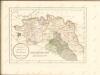
Tractus Rheni et Mosae, totusque Vahalis à Rhenoberca Gorcomium usque cum terris adjacentibus [...] [Karte, Teil 1], in: Novus Atlas, das ist, Weltbeschreibung, Bd. 1, S. 382.
1 Karte aus Atlas Blaeu, Joan Blaeu, Willem Janszoon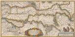
Tractus Rheni et Mosae totusque Vahalis à Rhenoberca Gorcomium usque cum terris adiacentibus [...] [Karte, Teil 1], in: Theatrum orbis terrarum, sive, Atlas novus, Bd. 1, S. 416.
1 Karte aus Atlas Blaeu, Joan Blaeu, Willem Janszoon
![Nouvelle Carte | representant la Ville de BOLDVC en plan, | avec ses Rempars, Fossez, Forteresses d'alentour etc. | Ensemble Les APPROCHES de chaque Quartier de ceux | de dehors jusques a la dite Ville : [fortification plan]](https://images-2.georeferencer.com/images/iiif/656239355852/full/,300/0/native.jpg)

