Maps of Arabian Peninsula

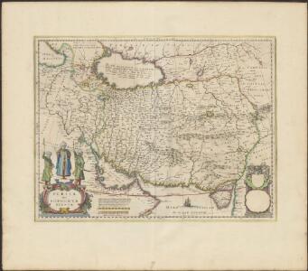
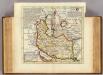
PERSIA | Sive | SOPHORVM | REGNVM
[Amsterdam : Joan Blaeu]
Persia Sive Sophorum Regnum [Karte], in: Theatrum orbis terrarum, sive, Atlas novus, Bd. 2, S. 269.
1 Karte aus Atlas Blaeu, Joan Blaeu, Willem Janszoon
Persia Sive Sophorum regnum [Karte], in: Novus Atlas, das ist, Weltbeschreibung, Bd. 2, S. 284.
1 Karte aus Atlas Blaeu, Joan Blaeu, Willem Janszoon

Persia, Sive Sophorum Regnum. [Karte], in: Gerardi Mercatoris et I. Hondii Newer Atlas, oder, Grosses Weltbuch, Bd. 2, S. 350.
1 Karte aus Atlas Mercator, Gerhard und Hondius, Jodocus Jansson, Jan
Persia, Sive Sophorum Regnum. [Karte], in: Novus atlas absolutissimus, Bd. 6, S. 111.
1 Karte aus Atlas Janssonius Offizin
Nieuwe kaart van 't ryk van Persie
1 : 9000000 Annotatie: Oorspr. verschenen in: Nieuwe hand-atlas ... - Amsterdam : Tirion, 1744 Amsterdam : Isaak Tirion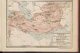
L'Hellénisme dans l'Antiquité [II]
Makedonien Hellenismus Altertum Kümmerly & Frey
Persia Sive Sophorum Regnum [Karte], in: Le théâtre du monde, ou, Nouvel atlas contenant les chartes et descriptions de tous les païs de la terre, Bd. 2, S. 260.
1 Karte aus Atlas Blaeu, Willem Janszoon und Blaeu, Joan Blaeu, Willem Janszoon
Vorder-Asien
Neuer Handatlas über alle Theile der Erde Kiepert, Heinrich Verlag von Dietrich Reimer
Persia Sive Sophorvm Regnvm / M. Merian fecit
1 : 13200000 1 Karte : Kupferdruck ; 26 x 34 cm [Matthäus Merian d. Ältere]
(Das Reich Kalifen in seiner grossten Ausdehnung) - Ost.
1 : 15200000 Spruner von Merz, Karl
West-Asien.
1 : 9700000 Stein, Christ. Gottfr. Dan.
[Historisch-geographischer Atlas zu den allgemeinen Geschichtswerken von C. v. Rotteck, Pölitz u. Becker] : Das Reich Alexanders des Grossen mit besonderer Angavbe Macedoniens unter Philipp u. der nach der Schlacht bei Ipsus entstandenen Reiche
von Julius Loewenberg Lithographie von B. Herder in Freiburg im Breisgau [Freiburg im Breisgau] : [Herder]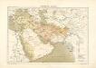
Atlas für Industrie- und Handelsgeographie: Für commercielle und technische Lehranstalten, für Kaufleute und Industrielle

Regiones inter Euphratem, Tigrim et Indum, India intra Gangem bor., Scythia extra Imaum, Serica
1 : 4250000 Asie západní Reichard, Christian Gottlieb Campius, D. a D. Campio
Persia, Caspian Sea, part of Independent Tartary.
1 : 13200000 Moll, Herman, d. 1732
Map of Persia, Turkey in Asia. Afghanistan, Beloochistan
1 : 14000000 Mitchell, Samuel Augustus Jr.
Tableau l'historie de L'Asie, Perse, Tartarie, Arabie.
1 : 29000000 Duval, Henri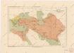
Říše Alexandra Velikého

Oriens.
1 : 25000000 Fenner, Rest.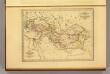
Empire d'Alexandre.
1 : 18000000 Malte-Brun, Conrad, 1775-1826
Tabula Asiae V [Karte], in: Claud. Ptolemaeus. Geographia lat. cum mappis [...], S. 308.
1 Karte aus Atlas Münster, Sebastian [und Ptolemaeus, Claudius]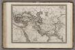
Empire d'Alexandre.
1 : 14200000 Monin, C.V.
Imperia Persarum et Macedonum.
1 : 12000000 Kiepert, Heinrich, 1818-1899
Iran und Turan oder Persien, Afghanistan, Belutschistan & Türkestan
Hand-Atlas über alle Theile der Erde und über das Weltgebäude Stieler, Adolf Justus Perthes
Imperii Persici in omnes suas provincias (tam veteribus quam modernis earundem nominibus signatas) e
1 : 6500000 1 Karte : Kupferdruck ; 47 x 56 cm Homann, Johann Baptist [Johann Baptist Homann]
Terra Inter Euphratem et Indum Antiqua
Schul-Atlas der alten Welt bei Justus Perthes