Maps of Great Rift Valley

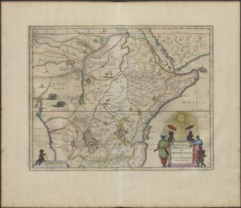
ÆTHIOPA | SVPERIOR vel INTERIOR; | vulgo | ABISSINORVM | sive | PRESBITERI IOANNIS | IMPERIVM.
[Amsterdam : Joan Blaeu]

Aethiopia Superior vel Interior; vulgo Abissinorum sive Presbiteri Ioannis Imperium [Karte], in: Novus Atlas, das ist, Weltbeschreibung, Bd. 2, S. 252.
1 Karte aus Atlas Blaeu, Joan Blaeu, Willem Janszoon
Aethiopia Superior vel Interior; vulgo Abissinorum sive Presbiteri Ioannis Imperium. [Karte], in: Theatrum orbis terrarum, sive, Atlas novus, Bd. 2, S. 301.
1 Karte aus Atlas Blaeu, Joan Blaeu, Willem Janszoon
Abissinorum Sive Pretiosi Ioanis Imperium. [Karte] Congi Regni in Africa Christiani Nova descriptio. [Nebenkarte], in: Gerardi Mercatoris Atlas, sive, Cosmographicae meditationes de fabrica mundi et fabricati figura, S. 505.
1 Karte aus Atlas Mercator, Gerhard Montanus, Petrus
Aethiopia Superior vel Interior; vulgo Abissinorum sive Presbiteri Ioannis Imperium. [Karte], in: Gerardi Mercatoris et I. Hondii Newer Atlas, oder, Grosses Weltbuch, Bd. 2, S. 373.
1 Karte aus Atlas Mercator, Gerhard und Hondius, Jodocus Jansson, Jan
Æthiopia superior vel interior; vulgo Abissinorum sive presbiteri Ioannis Imperium
1 : 12500000 Annotatie: Kaart uitg. in de periode ca. 1688-ca. 1700; Origineel is Blad 210 in atlas factice; Annotatie geografische gegevens: Schaalstok op kaart: 100 Milliaria Germanica communia (=6,1 cm) [Amsterdam] : [F. de Wit]
Aethiopia Superior vel Interior; vulgo Abissinorum sive Presbiteri Ioannis Imperium. [Karte], in: Le théâtre du monde, ou, Nouvel atlas contenant les chartes et descriptions de tous les païs de la terre, Bd. 2, S. 292.
1 Karte aus Atlas Blaeu, Willem Janszoon und Blaeu, Joan Blaeu, Willem Janszoon
Aethiopia Superior vel Interior; vulgo Abissinorum sive Presbiteri Ioannis Imperium. [Karte], in: Novus atlas absolutissimus, Bd. 6, S. 183.
1 Karte aus Atlas Janssonius Offizin
Haute Ethiopie, où sont l’Empire des Abissins
Haute Ethiopie, où sont l'Empire des Abissins ... et le Zanguebar.
Stanley in Africa
1 : 9500000 Ravenstein, E.G. Georg Philip & Son
Charte der Nordküste Africas, oder die staaten Maroccos, Fes, Algier, Tunis, Tripoli, und Aegypten : nach den neuesten und besten Hülfsmitteln
1 : 5000000 Reinecke, J. C. M. (Johann Christoph Matthias), 1770-1818 Verlage des Landes Indust. Compt.
170-171. Africa, Equatorial. The World Atlas.
1 : 7500000 USSR (Union of Soviet Socialist Republics).
[Afrika, Blatt 4]
Adolf Stieler's Handatlas über alle Theile der Erde und über das Weltgebäude Stieler, Adolf Justus Perthes
Africa (Northeast Part). Africa (Central Part).
1 : 12070000 Hammond, C.S.

Central & Southern Africa.
1 : 12000000 John Bartholomew and Son
Das Nordöstliche Africa
1 : 8000000 Afrika severovýchodní Lejean, Guillaume Marie Gräf, Adolph Geographisches Institut
Das Nordöstliche Africa
1 : 8000000 Afrika severovýchodní Lejean, Guillaume Marie Gräf, Adolph Geographisches Institut
Politische Übersicht von Ostafrika
1 : 8000000 Afrika jižní Kiepert, Heinrich Dietrich Reimer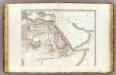
L'Afrique 2.
1 : 10000000 Brue, Adrien Hubert, 1786-1832
North Eastern Africa.
1 : 15000000 Colton, G.W.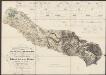
Carte Particuliere De La Mer Rouge &c. Levée Par Ordre Expres des Roys de Portugal sous qui on en a Fait la Decouverte. [Karte], in: Atlas nouveau, contenant toutes les parties du monde [...], Bd. 2, S. 228.
1 Karte aus Atlas Sanson, Nicolas Jaillot, Alexis Hubert und Mortier, Pieter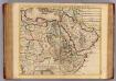
Egypte, Nubie, Abissinie &c.
1 : 9200000 L'Isle, Guillaume de, 1675-1726
Untitled

Inner Afrika. nach dem gegenwartigen stande der erforschung
1 : 17000000 Riemer, C.; Geographisches Institut. Weimar, Allemagne Weimar : Geographisches Institut
Riemer's Karte von Inner-Afrika
Afrika střední Riemer, C. Geographisches Institut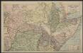
Afrique centrale. Congo-Nil
1 : 8000000 Niox, Gustave-Léon 1840-1921 Paris : Ch. Delagrave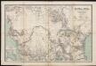
Karte von Central-Afrika. Nach den neuesten Forschungen bearbeitet von Dr. Joseph Chavanne.