Maps of Landes

[left] Carte | du | BOVRDELOIS, | du pais de | MEDOC, | et la prevosté | de | BORN; [right] PRINCIPATVS | BENEARNIA. | LA PRINCIPAVTE | DE BEARN
Guiljel. Blaeu exc.
Carte du Bourdelois, du pais de Medoc, et de la prevosté de Born. [Karte], in: Le théâtre du monde, ou, Nouvel atlas contenant les chartes et descriptions de tous les païs de la terre, Bd. 2, S. 140.
1 Karte aus Atlas Blaeu, Willem Janszoon und Blaeu, Joan Blaeu, Willem Janszoon
Bourdelois, Pays De Medoc, Et La Prevoste De Born. [Karte], in: Gerardi Mercatoris et I. Hondii Newer Atlas, oder, Grosses Weltbuch, Bd. 2, S. 122.
1 Karte aus Atlas Mercator, Gerhard und Hondius, Jodocus Jansson, Jan
Carte du Bourdelois, du pais de Medoc, et de la prevosté de Born. [Karte] , in: Novus Atlas, das ist, Weltbeschreibung, Bd. 2, S. 139.
1 Karte aus Atlas Blaeu, Joan Blaeu, Willem Janszoon
Carte du Bourdelois, du pais de Medoc, et de la prevosité de Born. [Karte], in: Theatrum orbis terrarum, sive, Atlas novus, Bd. 2, S. 125.
1 Karte aus Atlas Blaeu, Joan Blaeu, Willem Janszoon
Bourdelois, Pays De Medoc, Et La Prevoste De Born. [Karte], in: Novus atlas absolutissimus, Bd. 4, S. 162.
1 Karte aus Atlas Janssonius Offizin
Bovrdelois, pays de Medoc, et la prevoste de Born
1 Karte : Kupferdruck ; 36 x 48 cm Janssonius; Hamersvelt excudit Joannes Janssonius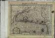
Bovrdelois, pais de Medoc et la prevoste de Born
1 Karte : Kupferdruck ; 17 x 24 cm Mercator Cloppenburgh

Bovrdelois, pays de Medoc, et la prevost de Born
1 : 600000 Bordeaux (Francie) Hamersveldt, Everard S. van P. Schenk et G. Valk
Carte du Bovrdelois, du pais de Medoc, et de la prevosté de Born
1 Karte : Kupferdruck ; 38 x 22 cm Blaeu Willem Janszoon Blaeu
Carte du Bovrdelois, du pais de Medoc, et de la prevosté de Born
2 Karten auf 1 Blatt : Kupferdruck ; zus. 39 x 51 cm Blaeu Guiljel. Blaeu exc
Bovrdelois, pays de Medoc, et la prevoste de Born
1 Karte : Kupferdruck ; 36 x 48 cm Hondius; Hamersvelt; Mercator excudit Judocus Hondius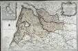
Direction de Bordeaux
1 Karte : Kupferdruck ; 46 x 72 cm Nolin; Loon chez J. B. Nolin ... a present rue St. Iacques
Composite 14: Carte de France.
1 : 86400 Cassini family; Cassini, Cesar-Francois, 1714-1784
Carte de la France, no. 14
1 Blatt : 60 x 92 cm s.n.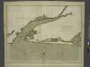
The river of BOURDEAUX and bay of ARCASSON
from The sea-atlas : containing an hydrographical description of most of the sea-coasts of the known parts of the world.
Département des Landes
1 Karte : Kupferdruck ; 48 x 48 cm Houdan; Dumez chez Dumez directeur de l'atlas national rue de la Harpe no. 26
La Riviere de la Garomne Et La Dordogne et le Pays aux environs de Bourdeaux. [Karte], in: Novus atlas absolutissimus, Bd. 4, S. 165.
1 Karte aus Atlas Janssonius Offizin
32) X.N.E. ''Bordeaux'', uit: Carte géologique de France
1 : 500000 Annotatie: Voor aanwezige bladen zie bladoverzicht [S.l : s.n.]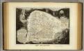
Dept. Des Landes.
1 : 563000 Levasseur, Victor.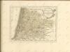
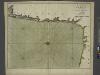
The sea coast of FRANCE from the bay of arcassin to bayon continued to gataria
from The sea-atlas : containing an hydrographical description of most of the sea-coasts of the known parts of the world.
38) X.S.E. ''Bayonne'', uit: Carte géologique de France
1 : 500000 Annotatie: Voor aanwezige bladen zie bladoverzicht [S.l : s.n.]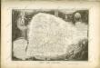

Département de la Gironde
1 Karte : Kupferdruck ; 65 x 49 cm Houdan au bureau de l'atlas national rue de la Harpe no. 26, et au depôt du dit atlas rue de la Monnoye no. 5
Le Pais De Bearn. [Karte], in: Gerardi Mercatoris et I. Hondii Newer Atlas, oder, Grosses Weltbuch, Bd. 2, S. 128.
1 Karte aus Atlas Mercator, Gerhard und Hondius, Jodocus Jansson, Jan
Le Pais De Bearn. [Karte], in: Novus atlas absolutissimus, Bd. 4, S. 168.
1 Karte aus Atlas Janssonius Offizin

![[left] Carte | du | BOVRDELOIS, | du pais de | MEDOC, | et la prevosté | de | BORN; [right] PRINCIPATVS | BENEARNIA. | LA PRINCIPAVTE | DE BEARN](https://images-2.georeferencer.com/images/iiif/563063472261/full/,300/0/native.jpg)

