Maps of Loiret

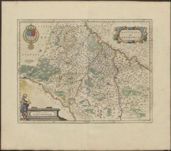
GASTINOIS | ET | SENONOIS
Amsterdami | Excud. Guiljemus | Blaeu
16) V.S.E. ''Orléans'', uit: Carte géologique de France
1 : 500000 Annotatie: Voor aanwezige bladen zie bladoverzicht [S.l : s.n.]

Gastinois Et Senonois. [Karte], in: Novus Atlas, das ist, Weltbeschreibung, Bd. 2, S. 54.
1 Karte aus Atlas Blaeu, Joan Blaeu, Willem Janszoon
Gastinois Et Senonois. [Karte], in: Theatrum orbis terrarum, sive, Atlas novus, Bd. 2, S. 62.
1 Karte aus Atlas Blaeu, Joan Blaeu, Willem Janszoon
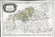
Gastinois et Senonois [Karte], in: Novus atlas absolutissimus, Bd. 4, S. 103.
1 Karte aus Atlas Janssonius Offizin
Gastinois Et Senonois [Karte], in: Gerardi Mercatoris et I. Hondii Newer Atlas, oder, Grosses Weltbuch, Bd. 2, S. 62.
1 Karte aus Atlas Mercator, Gerhard und Hondius, Jodocus Jansson, Jan
Gastinois Et Senonois. [Karte], in: Le théâtre du monde, ou, Nouvel atlas contenant les chartes et descriptions de tous les païs de la terre, Bd. 2, S. 54.
1 Karte aus Atlas Blaeu, Willem Janszoon und Blaeu, Joan Blaeu, Willem Janszoon
Karte vom Kriegestheater der vereinigten preussischen und östreichischen Armeen in Frankreich in VI. Blättern, [Blatt 7 und 10]
2 Teile auf 2 Blättern : 48 x 38 cm Königl. preuss. Akademische Kunst- und Buchhandlung
Gastinois et Senonois
1 : 340000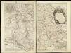
Carte topographique du Diocese de Sens divisé en ses cinq Archidiaconés et ses douze Doyennés
1 : 190080
[Gastinois et Senonois]
1 Karte : Kupferdruck ; 36 x 48 cm Janssonius apud Ioannem Ianssonium
Gastinois et Senonois
1 Karte : Kupferdruck ; 36 x 47 cm Valck; Schenk penes Gerardum Valk et Petrum Schenk
Gastinois et Senonois
1 Karte : Kupferdruck ; 37 x 48 cm Blaeu excud. Guiljelmus Blaeu
Gastinois et Senonois
1 Karte : Kupferdruck ; 35 x 47 cm Mercator; Hondius Henricus Hondius
Orléans 137, uit: Special-Karte von Mittel-Europa / nach amtlichen Quellen bearbeitet von W. Liebenow
1 : 300000 titelvariant: W. Liebenow's Mittel-Europa; Annotatie: Titel boven de bladen: W. Liebenow's Mittel-Europa Johannes Wilhelm Liebenow 1822-1897 Frankfurt a. M. : Ludwig Ravenstein
Orléans 137, uit: [W. Liebenow's Special-Karte von Mittel-Europa]
1 : 300000 titelvariant: W. Liebenow's Mittel-Europa; Annotatie: Titel boven de bladen: W. Liebenow's Mittel-Europa Johannes Wilhelm Liebenow 1822-1897 Hannover : Hermann Oppermann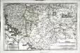
Senones
1 Karte : Kupferdruck ; 35 x 55 cm Sanson; Robert de Vaugondy; Liébaux chés le S. Robert geographe ord. du roi quai de l'Horloge
Département du Loiret
1 : 265000 Loiret (Francie) Houdan, François d' P. G. Chanlaire et Dumez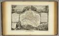
Dept. Du Loiret.
1 : 571000 Levasseur, Victor.
Département du Loiret
1 Karte : Kupferdruck ; 49 x 48 cm Houdan au bureau de l'atlas national de France rue Serpente n.o 15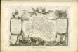
Senones
1 Karte : Kupferdruck ; 36 x 56 cm Sanson; Robert de Vaugondy chés le S. Robert geographe du roi quai de l'Horloge du Palais
[Atlas départemental : La France et ses colonies] No. 44 Loiret
1 : 670000 publ. par Michel fils ainé [dressé par A. Lorrain, et gravé par H. Dandeleux] Versailles [etc.] : Barreswil et Andrieux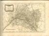

Département du Loiret
1 Karte : Kupferdruck ; 33 x 41 cm Capitaine s.n.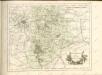
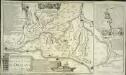
Les jonctions des deux grandes rivieres de Loire et de Seine par le nouveau canal d'Orleans et celuy de Briare
1 Karte : Kupferdruck ; 38 x 49 cm, Bildgrösse 38 x 64 cm Fer; Danet; Inselin se vend chez Danet gendre de l'auteur sur le pont N. Dame a la Sphere royale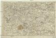
[Sud-est environs de Paris]
Paříž-oblast (Francie)