Maps of East Ayrshire

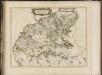
NITHIA VICECOMITATVS. | The Shirifdome of NIDIS-DAIL.
Auctore Timotheo Pont. [Amsterdam : Joan Blaeu]
Sheets 66-67. (Cary's England, Wales, and Scotland).
1 : 360000 Cary, John, ca. 1754-1835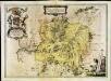
Nithia vicecomitatvs
1 Karte : Kupferdruck ; 37 x 52 cm Blaeu; Pont Joan Blaeu
Ayrshire, Sheet 4 - Bartholomew's "Half Inch to the Mile Maps" of Scotland
1 : 126720 Topographic maps John Bartholomew & Son, Ltd John Bartholomew & Son, Ltd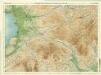
Ayr & Clydesdale, Sheet 4 - Bartholomew's "Half Inch to the Mile Maps" of Scotland
1 : 126720 Topographic maps Bartholomew, John George John Bartholomew & Co
Composite: Kirkcudbright-Shire.
1 : 114000 Thomson, John
The Shire of Dumfries or Nithisdale / by H. Moll.
Moll, Herman, d. 1732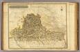
Kirkcudbright-Shire N.
1 : 114000 Thomson, John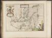
Nithia Vicecomitatus, The Shirifdome of Nidis-dail / auctore Timotheo Pont.
Pont, Timothy, 1560?-1614? Blaeu, Joan, 1596-1673
PRÆFECTVRA | KIRCVBRIENSIS, | quæ Gallovidiæ maxime orientalis pars est. | The Steuartrie of Kircubright, | The most easterlie part of Galloway.
Auct. Tim. Pont. [Amsterdam : Joan Blaeu]
Dumfriesshire.
Thomson, John, 1777- ca. 1840 Crawford, William & Son
Dumfriesshire.
Thomson, John, 1777- ca. 1840 Crawford, William & Son
Dumfriesshire.
Thomson, John, 1777- ca. 1840 Crawford, William & Son
Dumfriesshire.
Thomson, John, 1777- ca. 1840 Crawford, William & Son
Map of Dumfries-shire.
Crawford, William, fl. 1774-1828
Map of Dumfries-shire.
Crawford, William, fl. 1774-1828
Map of Dumfries-shire.
Crawford, William, fl. 1774-1828
Map of Dumfries-shire.
Crawford, William, fl. 1774-1828
The Stewartry of Kirkcudbright.
Ainslie, John, 1745-1828
The Stewartry of Kirkcudbright.
Ainslie, John, 1745-1828
The Stewartry of Kirkcudbright.
Ainslie, John, 1745-1828
The Stewartry of Kirkcudbright.
Ainslie, John, 1745-1828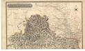
Kirkcudbright-Shire.
Thomson, John, 1777- ca. 1840 Johnson, William, fl. 1806-1840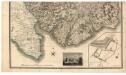
Kirkcudbright-Shire.
Thomson, John, 1777- ca. 1840 Johnson, William, fl. 1806-1840
Biggar Moffat and Sanquhar - OS One-Inch Map
1 : 63360 Topographic maps Ordnance Survey Ordnance Survey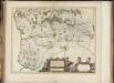
Praefectura Kircubriensis quae Gallovidiae maxime orientalis pars est. The Stuartrie of Kircubright, the most easterlie part of Galloway / auct. Tim. Pont.
Pont, Timothy, 1560?-1614? Blaeu, Joan, 1596-1673
Glottiana præfectvra svperior
1 Karte : Kupferdruck ; 38 x 52 cm Blaeu; Pont Joan Blaeu
Dumfries - OS One-Inch Map
1 : 63360 Topographic maps Ordnance Survey Ordnance Survey
Moffat - Bartholomew's 'Survey Atlas of Scotland'
1 : 126720 Topographic maps John Bartholomew & Son, Ltd John Bartholomew & Son, Ltd