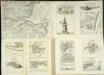
Maps of Kent

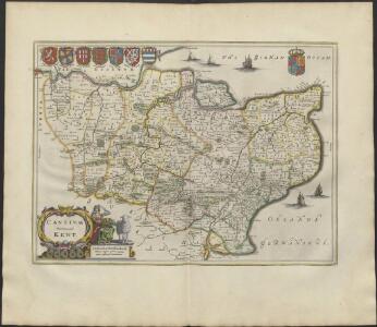
CANTIVM | Vernacule | KENT.
[Amsterdam : Joan Blaeu]
Cantium Vernacule Kent. [Karte], in: Novus atlas absolutissimus, Bd. 7, S. 122.
1 Karte aus Atlas Janssonius Offizin
Cantium Vernacule Kent. [Karte], in: Theatrum orbis terrarum, sive, Atlas novus, Bd. 4, S. 211.
1 Karte aus Atlas Blaeu, Joan Blaeu, Willem Janszoon
Cantium Vernacule Kent. [Karte], in: Le théâtre du monde, ou, Nouvel atlas contenant les chartes et descriptions de tous les païs de la terre, Bd. 4, S. 187.
1 Karte aus Atlas Blaeu, Willem Janszoon und Blaeu, Joan Blaeu, Willem Janszoon
Provincia di Kent
1 Karte : Kupferdruck ; 18 x 29 cm Zatta; Zuliani; Pitteri presso Antonio Zatta
A map of the county of Kent
1 Karte : Kupferdruck ; 49 x 70 cm Kitchin; Dury; Andrews; Herbert A. Dury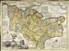
An accurate map of the county of Kent
1 Karte : Kupferdruck ; 50 x 69 cm Bowen; Hinton sold by J. Hinton at the Kings Arms in St. Pauls Church Yard
Cantivm vernacule Kent
1 Karte : Kupferdruck ; 37 x 51 cm Blaeu Joan Blaeu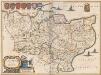
Cantium Vernacule Kent. [Karte], in: Theatrum orbis terrarum, sive, Atlas novus, Bd. 4, S. 211.
1 Karte aus Atlas Blaeu, Joan Blaeu, Willem Janszoon
Cantium vernacule Kent
1 : 130000 Amstelodami : apud Joannem Janssonium
Kent
Stent, Peter, Symonson, Philip and Whitwell, Charles Ordnance Survey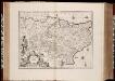
Cantium vernacule Kent / [Joannes Janssonius]
1 : 200000 Annotatie: Oorspr. verschenen in: Ioannis Ianssonii Atlas Novus ... - Amstelodami : apud Iohannem Ianssonium, 1646; Origineel is Blad 29 in atlas factice Janssonius, Joannes (jr.) (1588-1664) Amstelodami : apud Ioannem Ianssonium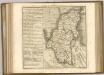
Bouche de la Tamise
1 Karte : Kupferdruck ; 22 x 28 cm Le Rouge Georges Louis Le Rouge
Kent, Sheet 31 - Bartholomew's "Half Inch to the Mile Maps" of England & Wales
1 : 126720 Topographic maps Bartholomew, John George John Bartholomew & Co
London SE - OS One-Inch Map
1 : 63360 Topographic maps Ordnance Survey Ordnance Survey
Chatham and Maidstone - OS One-Inch Map
1 : 63360 Topographic maps Ordnance Survey Ordnance Survey
East Kent - OS One-Inch Map
1 : 63360 Topographic maps Ordnance Survey Ordnance Survey
To the Right Honorable the Master, Wardens, and Elder Brethren, of the Trinity House, this chart of the Downs and Margate Roads is ... dedicated
1 : 56000 Heather, W. (William) Heather, W. (William)
Partie de l'Angleterre
1 : 110000 Anglie jižní Fricx, Eugene Henry Harrewyn, Jacques chez Eugene Henry Fricx
A sketch of the roads within fourteen miles of Tunbridge Wells
1 : 100000 Brackett, William Clifford, J J. Clifford
The description of Romney Marsh, Walland, Marshy, Denge and Gulforde marsh, with the divisions of their waterings, heads, armes, principal sewers and their gutts
This is a map of the Romney Marsh area, dating from around 1590. It shows the network of sewers and waterways in the area and is principally concerned with drainage. The locations of bridges are carefully recorded. The topography of the landscape is depicted with hills, trees, churches, towns, villages and windmills shown pictorially. A small island in the sea records the location where a village once stood. Camber castle is shown and the draughtsman has attempted to indicate the actual architectural features of the castle.
Hastings - OS One-Inch Map
1 : 63360 Topographic maps Ordnance Survey Ordnance Survey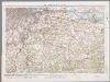
[Kaart], uit: S.E. London & Sevenoaks
1 : 64000 titelvariant: Ordnance Survey contoured road map of S.E. London and Sevenoaks; Annotatie: Omslagtitel: Ordnance Survey contoured road map of S.E. London and Sevenoaks Ordnance Survey Southampton : The Director General, at the Ordnance Survey Office
London passenger transport map
Ordnance Survey
London passenger transport map
Ordnance Survey
Faversham (Hills) - OS One-Inch Revised New Series
1 : 63360 Topographic maps Ordnance Survey Ordnance Survey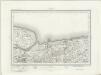
Faversham (Outline) - OS One-Inch Revised New Series
1 : 63360 Topographic maps Ordnance Survey Ordnance Survey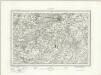
Canterbury (Outline) - OS One-Inch Revised New Series
1 : 63360 Topographic maps Ordnance Survey Ordnance Survey