Maps of Dorset

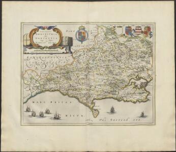
COMITATVS | DORCESTRIA, | sive | DORSETTIA; | Vulgo Anglice | DORSET SHIRE.
[Amsterdam : Joan Blaeu]
Comitatus Dorcestria, sive Dorsettia; Vulgo Anglice Dorset Shire. [Karte], in: Le théâtre du monde, ou, Nouvel atlas contenant les chartes et descriptions de tous les païs de la terre, Bd. 4, S. 127.
1 Karte aus Atlas Blaeu, Willem Janszoon und Blaeu, Joan Blaeu, Willem Janszoon
Comitatus Dorcestria, sive Dorsettia; Vulgo Anglice Dorset Shire. [Karte] , in: Theatrum orbis terrarum, sive, Atlas novus, Bd. 4, S. 143.
1 Karte aus Atlas Blaeu, Joan Blaeu, Willem Janszoon
Comitatus Dorcestria. Vulgo Anglice Dorset Shire. [Karte] , in: Novus atlas absolutissimus, Bd. 7, S. 192.
1 Karte aus Atlas Janssonius Offizin
Comitatus Dorcestria, sive Dorsettia; Vulgo Anglice Dorset Shire. [Karte] , in: Theatrum orbis terrarum, sive, Atlas novus, Bd. 4, S. 143.
1 Karte aus Atlas Blaeu, Joan Blaeu, Willem Janszoon
DORCESTRIAE
This map of Dorset is from the 1583 edition of the Saxton atlas of England and Wales. This atlas was first published as a whole in 1579. It consists of 35 coloured maps depicting the counties of England and Wales. The atlas is of great significance to British cartography as it set a standard of cartographic representation in Britain and the maps remained the basis for English county mapping, with few exceptions, until after 1750. During the reign of Elizabeth I map use became more common, with many government matters referring to increasingly accurate maps with consistent scales and symbols, made possible by advances in surveying techniques. Illustrating the increasing used of maps in government matters, Lord Burghley, Elizabeth I’s Secretary of State, who had been determined to have England and Wales mapped in detail from the 1550s, selected the cartographer Christopher Saxton to produce a detailed and consistent survey of the country. The financier of the project was Thomas Seckford Master of Requests at the Court of Elizabeth I, whose arms appear, along with the royal crest, on each map. Here the strap work cartouche is mounted by the Elizabethan coat of arms. The Seckford arms of appear at the bottom of the map, adjacent to the decorative scale bar which houses Saxton’s name. The adjacent counties are named but lack any internal detail, recording only the path of rivers that cross county boundaries. Relief, in the form of uniform rounded representations of hills, is the main topographical feature presented in the maps. Rather than provide a scientific representation of relative relief these give a general impression of the lie of the land. Settlements and notable buildings are also recorded pictorially; a small building with a spire represents a village, while more important towns are indicated by groups of buildings. Here Portland castle is marked by a castle symbol of two connected towers. Rivers, streams, parks and woodlands are also depicted carefully. Woods are shown by small tree-symbols, with clusters representing forests, and parklands enclosed with ring fences. Great decorative effect is provided by the detailed images of ships in the stippled sea. Saxton, Christopher Ryther, Augustine
DORCESTRIAE Comitatus
This is a map of Dorset by Christopher Saxton, datingfrom 1575. It forms part of an atlas that belonged to William Cecil Lord Burghley, Elizabeth I’s Secretary of State. Burghley used this atlas to illustrate domestic matters. This map is actually a proof copy of one which forms part of Christopher Saxton’s Atlas of England and Wales. This atlas was first published as a whole in 1579. It consists of 35 coloured maps depicting the counties of England and Wales. The atlas is of great significance to British cartography as it set a standard of cartographic representation in Britain and the maps remained the basis for English county mapping, with few exceptions, until after 1750. During the reign of Elizabeth I map use became more common, with many government matters referring to increasingly accurate maps with consistent scales and symbols, made possible by advances in surveying techniques. Illustrating the increasing use of maps in government matters, Lord Burghley, who had been determined to have England and Wales mapped in detail from the 1550s, selected the cartographer Christopher Saxton to produce a detailed and consistent survey of the country. The financier of the project was Thomas Seckford, Master of Requests at the Court of Elizabeth I, whose arms appear, along with the royal crest, on each map. Lord Burghley added several place names. In the lower margin there are notes concerning 'Dangerous places for landing of men in the county'. These notes were probably written by an assistant of Lord Burghley and show the concern felt about the south coasts vulnerability to invasion. Due to the presence of a Protestant Queen in the form of Elizabeth I, England was under threat from a catholic crusade from Philip II of Spain. This threat culminated in the events of the Spanish Armada in 1588. Saxton, Christopher William Cecil, Lord Burghley
An accurate map of Dorset Shire
1 Karte : Kupferdruck ; 52 x 68 cm Bowen; Tinney; Bowles; Sayer; Bowles; Bowles printed for John Bowles and son in Cornhil I. Tinney at the Golden Lion in Fleet street T. Bowles in St. Pauls Church Yard and Rob.t Sayer in Fleet Street
Comitatvs Dorcestria, sive Dorsettia; vulgo anglice Dorset Shire
1 Karte : Kupferdruck ; 37 x 49 cm Blaeu Joan Blaeu
Comitatus Dorcestria vulgo anglice Dorset Shire
1 : 170000 Amstelodami : apud Joannem Janssonium
An accurate map of Dorset Shire, divided into its hundreds
1 : 180000
An accurate map of Dorset Shire divided into hundreds
1 : 222000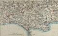
Map of Dorsetshire
This map comes from the Abbott's Illustrated Counties series of county guides: Dorsetshire, its history, antiquities, places of interest, etc a complete, concise and exhaustive story of Dorset from the earliest times to the present day' The Guide Printing & Publishing Co.
Comitatus Dorcestria, sive Dorsettia ; vulgo anglice Dorset Shire
1 : 145000
Dorset, Sheet 34 - Bartholomew's "Half Inch to the Mile Maps" of England & Wales
1 : 126720 Topographic maps Bartholomew, John George John Bartholomew & Co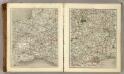
Sheets 13-14. (Cary's England, Wales, and Scotland).
1 : 360000 Cary, John, ca. 1754-1835
Cary's Improved Map of England and Wales
Cary, George, & Cary, John London : G. & J. Cary
Dorchester - OS One-Inch Map
1 : 63360 Topographic maps Ordnance Survey Ordnance Survey
Dorset Shire, 2
2 Blätter : 109 x 53 cm s.n.
Dorset Shire, 1
2 Blätter : 109 x 54 cm s.n.
Taunton and Lyme Regis - OS One-Inch Map
1 : 63360 Topographic maps Ordnance Survey Ordnance Survey
Dorset Shire, 3
2 Blätter : 109 x 45 cm s.n.
Bridport
The long stretch of sand in this plan is Chesil Beach. Once linked to Spain by well- established trade routes, it is also locally famed for reported sightings of the fabled Veasta Sea Monster. Signal points are marked along coast leading down to the beach, the most notable being Abbotsbury Castle Signal Staff on Abbotsbury Common. Pencil script records the date of execution and scale of the drawing. The words "Exhibit A" are written in blue pencil at the very edge of the sheet. A reference to the village of 'Wyke' (Wyke Regis) can be seen at the far right of the drawing. Budgen, Charles
Shaftesbury
1 : 31680 This drawing covers the counties of Dorset, Somerset and Wiltshire, with their boundaries marked by pecked red lines. Relief is indicated by shading and interlining, giving an impression of the undulations of the land. Although the recording of archaeological sites did not become obligatory until 1816, the remains of Whitesheet Castle appear at the top centre of the drawing. Pencil lines can be seen at the edge of the drawing near Pimperne. This was an observation or measuring point for the survey.
Weymouth
This drawing covers the coast of Weymouth Bay and the Isle of Portland. Lighthouses are marked on the tip of the island. Red lines denote stone walls. Sandsfoot Castle and Portland Castle are shown by blocks of red ink. These were among of a series of castles built by Henry VIII as defence against Spain and France after his divorce from the Catholic Catherine of Aragon and his breaking of ties with Rome. Chalbury Hillfort is indicated above Weymouth Bay. Archaeological sites were of interest to many of the draughtsmen and were often included even before it became obligatory to do so in 1816. The boundary with Purbeck is indicated by a red pecked line. Budgen, Charles
Beaminster
This drawing delineates the county borders of Dorset and Somerset with a red pecked line. Pillesdon Pen, a hillfort, is indicated by concentric rings to the left of the plan, although it did not become obligatory to record archaeological sites until 1816. The fort's position, 909 ft above sea level, is depicted by dark shading and brushwork interlining ('hachuring'). The summits of hills in this undulating countryside are left bare.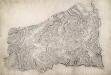
Sherborne
A red pecked line describes the border between the counties of Dorset and Somerset. Telegraph poles are marked by red dots along the lower edge of the drawing, indicating that the area covered is only a few miles from the coast. To the right of the landmass, red circles and crosses mark observation points outside the drawing's boundaries. Archaeological sites are also marked: an iron-age hillfort at Rawlsbury in the lower right is depicted by concentric rings. To the right of this is Dungeon Hill, a hillfort surrounded by a single rampart and a ditch, indicated by shading.
Dorchester
This drawing is very worn with some areas missing. The Ordnance Survey Letter Book notes that Mr Budgen was to be at Dorchester "on a new piece of work on the 29th Day of this Month", allowing us to be fairly certain of the authorship of this drawing. Maiden Castle - at 47 acres the largest iron age hillfort in Europe - is marked in the bottom left. The lines describing it follow the actual shape of the earthworks. Budgen, Charles
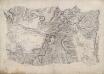
De reeden van Waijmouth en Poortland als ook de hoek van Poortland en van daer langs St. Andries Land tot de Peveral Punt int groot
England Gerard van Keulen