Maps of Aargau

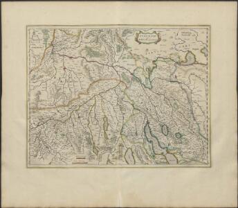
ZVRICHGOW | et | Basiliensis provincia
[Amsterdam : Joan Blaeu]
Zurichgow et Basiliensis provincia
1 : 300000 1 Karte A. van den Broeck fecit apud G. Valk et P. Schenk, Amstelodami
Zurichgow et Basiliensis provincia [Karte], in: Le théâtre du monde, ou, Nouvel atlas contenant les chartes et descriptions de tous les païs de la terre, Bd. 1, S. 288.
1 Karte aus Atlas Blaeu, Willem Janszoon und Blaeu, Joan Blaeu, Willem Janszoon
[Zurichgow, et Basiliensis provincia] [Karte], in: Gerardi Mercatoris et I. Hondii Newer Atlas, oder, Grosses Weltbuch, Bd. 1, S. 259.
1 Karte aus Atlas Mercator, Gerhard und Hondius, Jodocus Jansson, Jan
Zurichgow et Basiliensis provincia [Karte], in: Novus Atlas, das ist, Weltbeschreibung, Bd. 1, S. 257.
1 Karte aus Atlas Blaeu, Joan Blaeu, Willem Janszoon
Zurichgow et Basiliensis provincia [Karte], in: Theatrum orbis terrarum, sive, Atlas novus, Bd. 1, S. 294.
1 Karte aus Atlas Blaeu, Joan Blaeu, Willem Janszoon
[Zürich, Basel] [Karte], in: Gerardi Mercatoris Atlas, sive, Cosmographicae meditationes de fabrica mundi et fabricati figura, S. 264.
1 Karte aus Atlas Mercator, Gerhard Montanus, Petrus

Karte mit Teilen der Ost- und der Innerschweiz
Originaltitel: Le canton de Zurich. Möglicherweise: Bertius, Petrus (1565-1629), Geograf
Neue und exacte geograph. Tabell von der Statt Zürich Gebiett
1 : 600000 1 Karte cura Ioh. Hofmeisteri ; Tobias Lobeck deli. et sculp.
Zürichgau und Baselland
Originaltitel: Zurichgow et Basiliensis Provincia. Van den Broeck, A.
Schulwandkarte zur Geschichte der Schweiz
1 : 180000 1 Karte auf 6 Bl. bearbeitet v. W. Oechsli u. A. Baldamus ; gezeichnet von Ed. Gaebler Kartograph. Verlagsanstalt von Georg Lang, Leipzig
Zurichgow et Basiliensis provincia
1 : 300000 1 Karte A. van den Broeck fecit apud Johannem Janssonium, Amstelodami
Zurichgow et Basiliensis provincia
1 : 300000 1 Karte [apud Iohannem et Cornelium Blaeu], [Amsterdam]
[Zurichgow, et Basiliensis provincia]
1 : 250000 1 Karte per Gerardum Mercatorem [Mercator], [Duisburg]
Schulwandkarte zur Geschichte der Schweiz
1 : 180000 Nordblatt Oechsli, Wilhelm ; Baldamus, Alfred Kartograph. Verlagsanstalt von Georg Lang
[Zurichgow, et Basiliensis provincia]
1 : 250000 1 Karte per Gerardum Mercatorem [sumptibus & typis aeneis Iudoci Hondij], [Amsterodami]
[Zurichgow, et Basiliensis provincia]
1 : 250000 1 Karte per Gerardum Mercatorem [Hondius], [Amsterdam]
Zurichou [i.e. Zürichgau]
1 : 650000 1 Karte [von Jodocus Hondius] [excusum in aedibus Iudoci Hondij], [Amsterodami]
Reisekarte der Schweiz
1 : 500000 1 Atlas (1, 6 Bl.) gezeichnet von H. Keller und gestochen von J. Scheurmann = Carte routière de la Suisse / dessinée par H. Keller et gravée par J. Scheurmann bey Fuessli und Comp., Zürich
Eisenbahnnetz der Nordostbahn; Übersichtskarte
1 : 250000 Mit Legende. Eidgenössisches Stabsbüro
[Keller's Reisekarte der Schweiz]
1 : 500000 1 Karte auf 6 Bl. gezeichnet v. H. Keller ; gest. v. J.J. Scheurmann [Keller], Zürich
Zürich Gebiet
1 : 250000 1 Karte J.H. Streulinus inv. ; J.G. Seiller sculpsit
Neue und exacte geograph. Tabell von der Statt Zürich Gebiett
1 : 600000 1 Karte cura Ioh. Hofmeisteri ; Tobias Lobeck deli. et sculp.
Zvrichgow et Basiliensis provincia
1 : 310000 Mollova mapová sbírka Broeck, Abraham van den Janssonius Van Waesberge, Johannes II
Territorium der Republic Zürich
1 : 600000 1 Karte cura Ioh. Hofmeisteri
Topographische Karte des Kantons Zürich (Wild-Karte): Blatt IV: Übersicht der Blätter mit den Flächenräumen der Bezirke und Kirchgemeinden
1 : 250000 Leitung: Wild, Johannes (1814-1894), Ingenieur, von Richterswil Zeichnung: Enderli, Heinrich (1830-1902), Zeichner, von Wipkingen Stich: Graf, Josef (1811-1871), Lithograf, von Rottweil (Deutschland); Brack, Johann Jakob (1824-1867), Lithograf, von Neunforn TG
Totius S. R. I. Circuli Suevici Tabula Chorographica
1 : 310000 Mollova mapová sbírka Lamsvelt, Jan Ottens, Josua
Zürich 155, uit: Special-Karte von Mittel-Europa / nach amtlichen Quellen bearbeitet von W. Liebenow
1 : 300000 titelvariant: W. Liebenow's Mittel-Europa; Annotatie: Titel boven de bladen: W. Liebenow's Mittel-Europa Johannes Wilhelm Liebenow 1822-1897 Frankfurt a. M. : Ludwig Ravenstein