Maps of Opfenbach

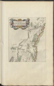
TERRITORII | LINDAVIENSIS | PARS SEPTENTRIONALIS
[Amsterdam : Joan Blaeu]
Meßtischblatt [8324] : Neukirch (Württ.), Achberg (Preuß.), 1911
1 : 250000 Neukirch (Württ.), Achberg (Preuß.). - Hrsg. 1895, 2. Ausg., 1911. - 1:25000. - Stuttgart, 1911. - 1 Kt.
CIVITATIS IMP. | LINDAVIENSIS | TERRITORIVM.
ita Delineabat | Iohannes Andreas Rauhen. [Amsterdam : Joan Blaeu]
Boden-See
1 : 75000 Kartograph., früher Militärgeograph. Inst.
Comitatvs Tetnang Illustr. Comitum de Montfort, et confinia
1 : 120000 Mollova mapová sbírka Merian, Matthaeus Merian, Matthäus
Blatt V: Rheineck, Verzeichniss von Ortsbenennungen in verschiedenen Sprachen, uit: Topographische Karte der Schweiz / vermessen und hrsg. ... unter Aufsicht des Generals G.H. Dufour
1 : 100000 Annotatie: Met plaatsnamenregister (bl. V), bladwijzer (bl. XXI) en hoogteregister (bl. XXV); Voor aanwezige bladen zie overzichtsblad Dufour, G. H. [Bern : Eidg. Topogr. Bureau]
Topographische Karte der Schweiz (Dufour-Karte): Den Kanton Zürich betreffende Blätter: Blatt V: Rheineck; Verzeichnis von Ortsbenennungen in verschiedenen Sprachen, Zeichen und Abkürzungen
1 : 100000 Leitung: Dufour, Guillaume-Henri (1787-1875), General, Politiker, Ingenieur und Kartograf, von Genf; Eidgenössisches Topographisches Bureau, in Genf Stich: Bressanini, Rinaldo (1803-1864), Kupferstecher und Kartograf, von Italien; Müllhaupt, Heinrich (1820-1894), Kupferstecher und Kartograf, von Hofstetten; Werdmüller, Johann Conrad (1826-1849), Kupferstecher, in Genf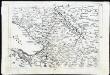
[Landvogdey in Schwaben]
Bodenehr, Johann Georg
Bodensee.
from Spezialkarte der osterreichisch-ungarischen Monarchie.
Bodenseekarte
1 : 50000 Ost-Blatt Eidgenössisches Topographisches Bureau Eidg. Topogr. Büreau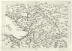
Geographica Provinciarum Sveviae Descriptio =
Mollova mapová sbírka Hurter, Johann Christoph Bodenehr, Johann Georg
187. Lindau, uit: Topographische Uebersichtskarte des Deutschen Reiches / herausgegeben v. d. Kartogr. Abt. d. Königl. Preuß. Landesaufnahme
1 : 200000 titelvariant: Topogr. Übersichtskarte des Deutschen Reiches; Annotatie: Titel boven bladen ook: Topogr. Übersichtskarte des Deutschen Reiches; Annotatie geografische gegevens: Op elk blad twee maatstokken: 10 Kilometer = 5,5 cm; 1 geogr. Meile = 3,6 cm; Legenda onder op elk blad Königlich Preußische Landesaufnahme. Kartographische Abtheilung [S.l : Königlich Preußische Landesaufnahme, Kartographische Abtheilung]
<<Der>> Boden-See
1 Vogelschaukarte Orell Füssli, Zürich
Situation der Linie Constanz - Romanshorn - Rorschach
1 : 100000 1 Karte [Kartogr.:] Topogr. Anst. v. Wurster, Randegger & Cie. in Winterthur Schweizerische Nordostbahn, [Erscheinungsort nicht ermittelbar]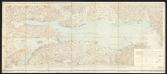
Bodenseekarte
1 : 50000 Schweiz Eidgenössisches Topographisches Bureau Eidg. Topogr. Büreau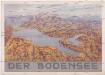
Der Bodensee
Bodamské jezero (oblast) M. Wittkop
Topographische Karte der Schweiz
1 : 100000 25 Karten vermessen und hrsg. auf Befehl der Eidgenössischen Behörden ; aufgenommen unter der Aufsicht des Generals G.H. Dufour Eidg. Topographisches Bureau, [Genève], [später: Bern]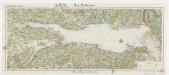
[Kaart], uit: Der Bodensee
1 : 100000 Annotatie: Verso: toeristische informatie Stuttgart : Von Paasche & Luz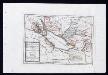
Das Bisthum Constanz, die Grafschaft Montfort oder die Herrschaften Tetnang und Argen, die Grafschaften Hohenembs, Vadutz und Schellenberg mit den freyen Reichsstädten Ueberlingen, Wangen, Lindau und Buchhorn : Nro. 196
Reilly, Franz Johann Joseph von
Provincia Arlbergica Sequentes Comitatus, aliosque Dominatus Austriacos, Brigantinum nempe, Hoheneckensem, Veldkirchensem, Bludentinum, et Sonnenbergensem in se Complectens,...
Hueber, Blasius
Provincia Arlbergica Sequentes Comitatus, aliosque Dominatus Austriacos, Brigantinum nempe, Hoheneckensem, Veldkirchensem, Bludentinum, et Sonnenbergensem in se Complectens,...
Hueber, Blasius
Provincia Arlbergica Sequentes Comitatus, aliosque Dominatus Austriacos, Brigantinum nempe, Hoheneckensem, Veldkirchensem, Bludentinum, et Sonnenbergensem in se Complectens,...
Hueber, Blasius
Partie du ct. Sentis et Autriche anterieure
1 : 108000 Weiss, Johann Heinrich ; Guérin, Christophe ; Meyer, Johann Rudolf J. R. Meyer
Partie Du Ct. Sentis Et Autriche Anterieure
1 : 120000 Weiss, Johann Heinrich Mayer Johann Rudolf
Charte von Vorarlberg
Diewald, Johann Nepomuk Homann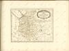

Lacus Bodamicus vel Acronius cum regionibus circumiacentibus
Seutter, Matthäus Probst
Suevia Universa :
1 : 170000 Mollova mapová sbírka Michal, Jacques de Seutter, Matthäus Seutter, Matthäus
De Graafschappen Bregentz, Hogen Embs, Feldkirchen, Sonnenberg en Bludentz : Na de Nieuste Kaarte Uitgegeven
I. B. Elwe & D. M. Langeveld
Lacus Bodamicus vel Acronius
1 Karte : Kupferdruck ; 46 x 54 cm Probst; Seutter anjezo in Verlag bey Ioh. Michael Probst Chalc
Lacus Bodamicus vel Acronius
1 Karte : Kupferdruck ; 46 x 54 cm Probst; Seutter anjezo in Verlag bey Ioh. Michael Probst Chalc
Lacus Bodamicus vel Acronius
1 Karte : Kupferdruck ; 46 x 54 cm Probst; Seutter anjezo in Verlag bey Ioh. Michael Probst Chalc