Maps of Hamburg

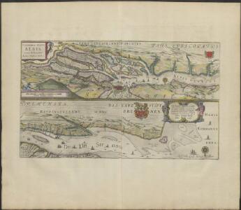
CELEBERRIMI FLVVII | ALBIS | nova delineatio
Auctore Christiano Mollero. Amstelodami, Guilj. Blaeuw Excudit.
Celeberrimi Fluvii Albis nova delineatio [Karte, Teil 1], in: Theatrum orbis terrarum, sive, Atlas novus, Bd. 1, S. 182.
1 Karte aus Atlas Blaeu, Joan Blaeu, Willem Janszoon
Celeberrimi Fluvii Albis nova delineatio [Karte, Teil 1], in: Le théâtre du monde, ou, Nouvel atlas contenant les chartes et descriptions de tous les païs de la terre, Bd. 1, S. 148.
1 Karte aus Atlas Blaeu, Willem Janszoon und Blaeu, Joan Blaeu, Willem Janszoon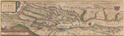
Celeberrimi Fluvii Albis nova delineatio [Karte, Teil 1], in: Novus Atlas, das ist, Weltbeschreibung, Bd. 1, S. 117.
1 Karte aus Atlas Blaeu, Joan Blaeu, Willem Janszoon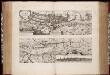
Nobilis fluvius Albis : maximâ curâ, ex varijs, famosisq. ... / a Nicolao Johannide Piscatore
1 : 152900 Annotatie: Origineel is Blad 81 in atlas factice; Annotatie geografische gegevens: Schaalstok: 2 Miliaria Germanica communia quorum 15 gradum unum latitudinis constituunt = 9 cm; Zuid boven; Inzet: Emporium Hamburgum Claes Jansz. Visscher 1586/1587-1652 [S.l. : s.n.]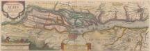
Nobilis Fluvius Albis maximâ curâ, ex variis famosisque Autoribus collectus, et in lucem editus. [Karte, Teil 1], in: Novus atlas absolutissimus, Bd. 2, S. 33.
1 Karte aus Atlas Janssonius Offizin
Nobilis Fluvius Albis maximâ curâ, ex variis, famosisque Autoribus collectus, et in lucem editus. [Karte, Teil 1], in: Gerardi Mercatoris et I. Hondii Newer Atlas, oder, Grosses Weltbuch, Bd. 1, S. 277.
1 Karte aus Atlas Mercator, Gerhard und Hondius, Jodocus Jansson, Jan
Karte von der Gegend um Hamburg
1 : 140000
Karte von Hamburg nebst Umgebung für Touristen
1 : 100000 Hamburg : Verlag der Lith. Institut von Ch. Fuchs
Prospect und Grundris der Keiserl. Freyen Reichs und Ansee Stadt Hamburg, samt ihrer Gegend
1 : 40000 Mollova mapová sbírka Homann, Johann Baptist Homann, Johann Baptista
Composite: 146. Hamburg. (Germany)
1 : 100000 Reichsamt fur Landesaufnahme
Plan von Hamburg
Hamburk (Německo) Georg Vigand's Verlag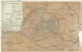
Plan von Hamburg mit seinen Vorstädten
1 : 12600 Hamburk (Německo) Grieben, Th. Th. Grieben
Entwurf des generalplanes für die stadtweiterung. Blatt 1
1 : 20000 Meyer, Andreas, fl. 1896 Photolithographie v. Strumper & Co.
Nordsee
1 : 25000 Altona (Hamburk, Německo) Reichs-Marine-Amt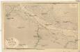
Nordsee
1 : 25000 Labe (Česko a Německo : řeka : dolní tok) Reichs-Marine-Amt
Prospect und Grundris der keiserl. freyen Reichs und Ansee Stadt Hamburg, samt ihrer Gegend
1 : 40000 Hamburk (Německo) Homann, Johann Baptist Ioh. Bapt. Homann
Prospect und Grundris der keiserl. freyen Reichs und Ansee Stadt Hamburg, samt ihrer Gegend
1 : 40700 Hamburk (Německo) Homann, Johann Baptist Ioh. Bapt. Homann
145. Stade. (Germany)
1 : 100000 Reichsamt fur Landesaufnahme
Plan zur Veranschaulichung der Wasserversorgung Hamburg's, mit der Situation der projectirten Filtrations Anlage
1 : 20000 Strumper & Co.
Bez titulu: Politische Weltkarte

H. Carly's Bebauungs-Plan von Hamburg und sämtlichen Hamburgischen Vororten : nebst Plan von Altona-Ottensen, Wandsbeck und Umgebung sowie Plan von Hagenbecks Tierpark
Carly, H Druck und Verlag H. Carly (Inh. Oscar und Robert Enoch)
Grosser Plan von Hamburg, Altona-Ottensen und Wandsbek
1 : 14000 Verl.-Anst. (vormals J. Richter)
Meßtischblatt 1123 : Bergedorf, 1922
1 : 250000 Bergedorf. - Aufn. 1878, bericht. 1922. - 1:25000. - [Berlin]: Reichsamt für Landesaufnahme, 1922. - 1 Kt.
Meßtischblatt 1122 : Allermöhe, 1933
1 : 250000 Allermöhe. - Hrsg. 1880/81, bericht. 1927, gedr. [19]33. - 1:25000. - [Berlin]: Reichsamt für Landesaufnahme, 1933. - 1 Kt.
Meßtischblatt 1121 : Harburg- Wilhelmsburg, 1934
1 : 250000 Harburg- Wilhelmsburg. - Hrsg. 1880/81, bericht. 1927, gedr. [19]34. - 1:25000. - [Berlin]: Reichsamt für Landesaufnahme, 1934. - 1 Kt.
Meßtischblatt 1120 : Buxtehude, 1935
1 : 250000 Buxtehude. - Hrsg. 1899, bericht. 1927, einz. Nachtr. 1931. - 1:25000. - [Berlin]: Reichsamt für Landesaufnahme, 1935. - 1 Kt.
Meßtischblatt 1119 : Harsefeld, 1899
1 : 250000 Harsefeld. - Aufn. 1897, hrsg. 1899. - 1:25000. - [Berlin]: Reichsamt für Landesaufnahme, 1899. - 1 Kt.
Meßtischblatt 1031 : Glinde, 1933
1 : 250000 Glinde. - Hrsg. 1880, bericht. 1922. - 1:25000. - [Berlin]: Reichsamt für Landesaufnahme, 1933. - 1 Kt.
Meßtischblatt 1030 : Wandsbek, 1927
1 : 250000 Wandsbek. - Aufn. 1878, bericht. 1927. - 1:25000. - [Berlin]: Reichsamt für Landesaufnahme, 1927. - 1 Kt.