Maps of Ostholstein

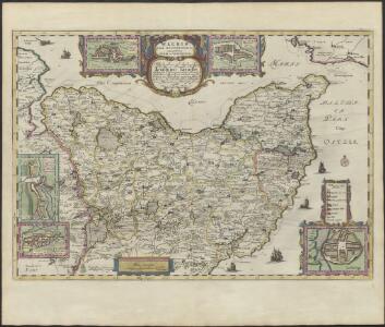
WAGRIÆ | PARS SEPTENTRIONALIS | cum præfectura | CISMAR et OLDENBVRGH.
Christian Lorensen | Rodtgiesser sculps. [Amsterdam : Joan Blaeu]
Wagriae Pars Septentrionalis cum praefectura Cismar et Oldenbvrgh
1 : 130000 Mollova mapová sbírka Mejer, Johannes Rothgiesser, Christian Lorenzen Blaeu, Joan I.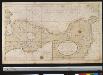
Een gedeelte van de kust van Holsteijn van Kijll of Kielerford tot Femere of New Stadt in de Belt Oost Zee
Germany Gerard van Keulen
24. Eutin, uit: Topographische Uebersichtskarte des Deutschen Reiches / herausgegeben v. d. Kartogr. Abt. d. Königl. Preuß. Landesaufnahme
1 : 200000 titelvariant: Topogr. Übersichtskarte des Deutschen Reiches; Annotatie: Titel boven bladen ook: Topogr. Übersichtskarte des Deutschen Reiches; Annotatie geografische gegevens: Op elk blad twee maatstokken: 10 Kilometer = 5,5 cm; 1 geogr. Meile = 3,6 cm; Legenda onder op elk blad Königlich Preußische Landesaufnahme. Kartographische Abtheilung [S.l : Königlich Preußische Landesaufnahme, Kartographische Abtheilung]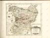

Wagria quae est Pars Orientalis Holsatiae
1 : 190000 Mollova mapová sbírka Janssonius, Johannes Schenk, Peter I
Composite: 83. Eutin. (Germany)
1 : 100000 Reichsamt fur Landesaufnahme
Composite: 60. Oldenburg i/Holst. (Germany)
1 : 100000 Reichsamt fur Landesaufnahme
59. Lutjenburg. (Germany)
1 : 100000 Reichsamt fur Landesaufnahme
Composite: 59. Lutjenburg. (Germany)
1 : 100000 Reichsamt fur Landesaufnahme
83. Eutin. (Germany)
1 : 100000 Reichsamt fur Landesaufnahme
84. Gromitz. (Germany)
1 : 100000 Reichsamt fur Landesaufnahme
60. Oldenburg i/Holst. (Germany)
1 : 100000 Reichsamt fur Landesaufnahme
Composite: 84. Gromitz. (Germany)
1 : 100000 Reichsamt fur Landesaufnahme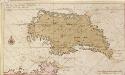
Afteekening vant eijland Femeren geleegen aen de zuijtwal in de Belt
Germany Gerard van Keulen
FIMBRIÆ, | Vulgo | FEMEREN | DELINEATIO | GEOMETRICA.
[Amsterdam : Joan Blaeu]
Meßtischblatt502 : Klostersee, 1930
1 : 250000 Klostersee. - Hrsg. 1879, einz. Nachtr. 1930. - 1:25000. - [Berlin]: Reichsamt für Landesaufnahme, 1930. - 1 Kt.
Meßtischblatt 501 : Grömitz, 1889
1 : 250000 Grömitz. - Aufn. 1877, hrsg. 1879, einz. Nachtr. 1889. - 1:25000. - [Berlin]: Reichsamt für Landesaufnahme, 1889. - 1 Kt.
Meßtischblatt 500 : Neustadt (i. Holstein), 1928
1 : 250000 Neustadt (i. Holstein). - Hrsg. 1879, einz. Nachtr. 1928. - 1:25000. - [Berlin]: Reichsamt für Landesaufnahme, 1928. - 1 Kt.
Meßtischblatt 499 : Eutin, 1891
1 : 250000 Eutin. - Aufn. 1877, hrsg. 1879, einz. Nachtr. 1891. - 1:25000. - [Berlin]: Reichsamt für Landesaufnahme, 1891. - 1 Kt.
Meßtischblatt 498 : Plön, 1879
1 : 250000 Plön. - Aufn. 1877. - 1:25000. - [Berlin]: Reichsamt für Landesaufnahme, 1879. - 1 Kt.
Meßtischblatt 497 : Stolpe (i. Schleswig), 1896
1 : 250000 Stolpe (i. Schleswig). - Aufn. 1877, hrsg. 1879, einz. Nachtr. 1896. - 1:25000. - [Berlin]: Reichsamt für Landesaufnahme, 1896. - 1 Kt.
Meßtischblatt 432 : Grube, 1930
1 : 250000 Grube. - Hrsg. 1879, einz. Nachtr. 1930. - 1:25000. - [Berlin]: Reichsamt für Landesaufnahme, 1930. - 1 Kt.
Meßtischblatt 431 : Oldenburg (in Holstein), 1930
1 : 250000 Oldenburg (in Holstein). - Hrsg. 1879, einz. Nachtr. 1930. - 1:25000. - [Berlin]: Reichsamt für Landesaufnahme, 1930. - 1 Kt.
Meßtischblatt 430 : Hansühn, 1879
1 : 250000 Hansühn. - Aufn. 1877. - 1:25000. - [Berlin]: Reichsamt für Landesaufnahme, 1879. - 1 Kt.
Meßtischblatt 429 : Lütjenburg, 1919
1 : 250000 Lütjenburg. - Aufn. 1877, Nachtr. 1919. - 1:25000. - [Berlin]: Reichsamt für Landesaufnahme, 1919. - 1 Kt.
Meßtischblatt 428 : Selent, 1919
1 : 250000 Selent. - Aufn. 1877, Nachtr. 1919. - 1:25000. - [Berlin]: Reichsamt für Landesaufnahme, 1919. - 1 Kt.
Meßtischblatt 427, neue Nr. 1727 : Preetz, 1879
1 : 250000 Preetz. - Aufn. 1877, hrsg. 1879. - 1:25000. - [Berlin]: Reichsamt für Landesaufnahme, 1879. - 1 Kt.
Meßtischblatt 367, neue Nr. 1632 : Grossenbrode, 1879
1 : 250000 Grossenbrode. - Aufn. 1877, hrsg. 1879. - 1:25000. - [Berlin]: Reichsamt für Landesaufnahme, 1879. - 1 Kt.