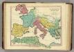
Maps of Mediterranean Sea

[Historisch-geographischer Atlas zu den allgemeinen Geschichtswerken von C. v. Rotteck, Pölitz u. Becker] : Die Reiche im Süden Europa's im Anfange des achten Jahrhunderts
von Julius Loewenberg Lithographie von B. Herder in Freiburg im Breisg. [Freiburg im Breisgau] : [Herder]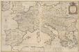
Imperii Caroli Magni et vicinarum regionum Descriptio [...] [Karte], in: Novus Atlas, das ist, Weltbeschreibung, Bd. 2, S. 165.
1 Karte aus Atlas Blaeu, Joan Blaeu, Willem Janszoon
Imperii Caroli Magni et vicinarum regionum Descriptio [Karte], in: Le théâtre du monde, ou, Nouvel atlas contenant les chartes et descriptions de tous les païs de la terre, Bd. 2, S. 165.
1 Karte aus Atlas Blaeu, Willem Janszoon und Blaeu, Joan Blaeu, Willem Janszoon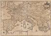
Imperium Caroli Magni [Karte], in: Novus atlas absolutissimus, Bd. 4, S. 28.
1 Karte aus Atlas Janssonius Offizin
[Historisch-geographischer Atlas zu den allgemeinen Geschichtswerken von C. v. Rotteck, Pölitz u. Becker] : Das Weströmische Reich bis zu seinem Untergange unter Romulus Augustulus
von Julius Loewenberg Lithographie von B. Herder in Freiburg im Breisgau [Freiburg im Breisgau] : [Herder]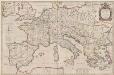
Imperii Caroli Magni et vicinarum regionum Descriptio [Karte], in: Theatrum orbis terrarum, sive, Atlas novus, Bd. 2, S. 167.
1 Karte aus Atlas Blaeu, Joan Blaeu, Willem Janszoon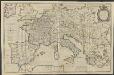
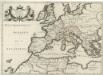
IMPERII | CAROLI MAGNI | et vicinarum regionum | DESCRIPTIO, | Dedicata et inscripta | LVDOVICO, | REGI, VICTORI, | ET DEFENSORI ECCLESIÆ | CHRISTI
ab Auctore Petro Bertio | ejusdem Cosmographo. [Amsterdam : Joan Blaeu]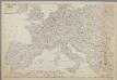
Centraal-, West-, en Zuid-Europa
1 : 3700000 [S.l. : s.n.]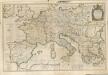

Europa Prima Nova Tabula [Karte], in: Geographia universalis vetus et nova complectens Claudii Ptolemaei Alexandrini enarrationis libros VIII, S. 302.
1 Karte aus Atlas Münster, Sebastian [und Ptolemaeus, Claudius]
[Personifizierte Europa als Königin mit Reichsapfel und Zepter, Hispania bildet den Kopf]
1 Karte : Holzschnitt ; 16 x 26 cm Münster, Sebastian [Sebastian Münster]
[Personifizierte Europa als Königin mit Reichsapfel und Zepter, Hispania bildet den Kopf]
1 Karte : Holzschnitt ; 16 x 26 cm Münster, Sebastian [Sebastian Münster]
Landtaflen
1 Atlas [von Johannes Stumpf] Christoffel Froschower, Zürych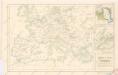
Západní a střední Evropa v době absolutismu až do konce francouzské revoluce
Patriarchati Occidentalis. (1826)
1 : 12100000 Tanner, Henry S.
Europa Saeculo XVIII. Usque ad Annum 1789 (1795)
Europa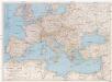
Central Europe and the Mediterranean
1 : 5000000 Evropa National Geographic Society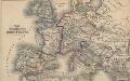
Das Zeitalter der Hohenstaufen
Mitteleuropa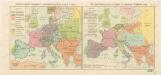
Rozsah panství Habsburků ... za Karla V. (1555) Říše Napoleonova (1810) a Evropa po kongresu Vídeňském (1815)

Carte d'Europe indiquant le canal maritime de l'océan à la Méditerranée
1 : 16000000 Perrin, Maurice [Paris] : [éditeur inconnu]
Europa im Zeitalter Wilhelms I.
1 : 15000000 Europa Wilhelm I., Deutsches Reich, Kaiser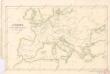
Evropa v době humdsko - germánské od 4. do 6. stol.
Patriarchatus Romanus
1 : 11100000 Mollova mapová sbírka Sanson, Nicolas Covens, Johannes I
Europa temporibus expeditionum sacrarum
Evropa Kunst u geogr. Anstalt von Serz & C.ie
Napoleons Heereszüge : von seinem Auftreten als Ober-General der Armee von Italien 1796 bis zu seiner Thron-Entsagung nach der Schlacht bey Waterloo 1815
Entworfen von F.W. Benicken gravirt v. C. Halle Weimar : im Verlage des Landes Industrie-Comptoirs
Nieuwste oorlogskaart van Europa
1 : 6000000 A[mster]dam : Meulenhoff
Europa Temporibus Expeditionum Sacrarum
Europa Kreuzzüge
Europa im Zeitalter Napoleons
1 : 15000000 Europa Napoleon I., Frankreich, Kaiser
Europa Prima Nova Tabula [Karte], in: Claud. Ptolemaeus. Geographia lat. cum mappis [...], S. 332.
1 Karte aus Atlas Münster, Sebastian [und Ptolemaeus, Claudius]
![[Historisch-geographischer Atlas zu den allgemeinen Geschichtswerken von C. v. Rotteck, Pölitz u. Becker] : Die Reiche im Süden Europa's im Anfange des achten Jahrhunderts](https://images-2.georeferencer.com/images/iiif/478198037440/full/,300/0/native.jpg)

